Binfield Topo Map Tennessee
To zoom in, hover over the map of Binfield
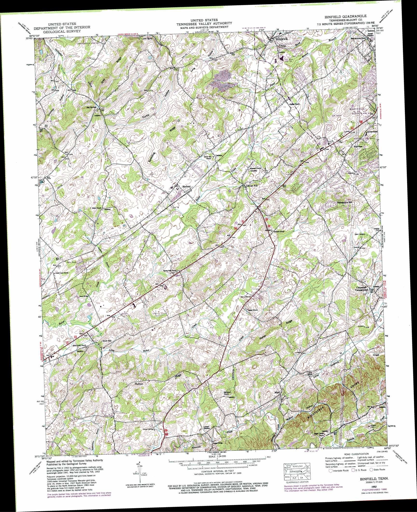
USGS Topo Quad 35084f1 - 1:24,000 scale
| Topo Map Name: | Binfield |
| USGS Topo Quad ID: | 35084f1 |
| Print Size: | ca. 21 1/4" wide x 27" high |
| Southeast Coordinates: | 35.625° N latitude / 84° W longitude |
| Map Center Coordinates: | 35.6875° N latitude / 84.0625° W longitude |
| U.S. State: | TN |
| Filename: | o35084f1.jpg |
| Download Map JPG Image: | Binfield topo map 1:24,000 scale |
| Map Type: | Topographic |
| Topo Series: | 7.5´ |
| Map Scale: | 1:24,000 |
| Source of Map Images: | United States Geological Survey (USGS) |
| Alternate Map Versions: |
Binfield TN 1935 Download PDF Buy paper map Binfield TN 1941 Download PDF Buy paper map Binfield TN 1941 Download PDF Buy paper map Binfield TN 1952, updated 1954 Download PDF Buy paper map Binfield TN 1952, updated 1965 Download PDF Buy paper map Binfield TN 1952, updated 1990 Download PDF Buy paper map Binfield TN 2010 Download PDF Buy paper map Binfield TN 2013 Download PDF Buy paper map Binfield TN 2016 Download PDF Buy paper map |
1:24,000 Topo Quads surrounding Binfield
Bethel Valley |
Lovell |
Bearden |
Knoxville |
Shooks Gap |
Lenoir City |
Concord |
Louisville |
Maryville |
Wildwood |
Loudon |
Meadow |
Binfield |
Blockhouse |
Kinzel Springs |
Madisonville |
Vonore |
Tallassee |
Calderwood |
Cades Cove |
Mount Vernon |
Rafter |
Whiteoak Flats |
Tapoco |
Fontana Dam |
> Back to 35084e1 at 1:100,000 scale
> Back to 35084a1 at 1:250,000 scale
> Back to U.S. Topo Maps home
Binfield topo map: Gazetteer
Binfield: Bridges
Henry Bridge elevation 260m 853′Reagan Bridge elevation 267m 875′
Binfield: Dams
Kagley Dam elevation 287m 941′Binfield: Populated Places
Alnwick elevation 286m 938′Bestview elevation 320m 1049′
Big Springs elevation 275m 902′
Binfield elevation 293m 961′
Brick Mill elevation 276m 905′
Cherokee Heights elevation 329m 1079′
Christy Hill elevation 297m 974′
Clover Hill elevation 284m 931′
Clover Hill Estates elevation 307m 1007′
Country Haven elevation 359m 1177′
Fairview elevation 352m 1154′
Fairview Heights elevation 341m 1118′
Fairway Estates elevation 348m 1141′
Forest Glen elevation 312m 1023′
Green Valley elevation 337m 1105′
Greenwood elevation 341m 1118′
Homestead Acres elevation 289m 948′
Kenmark Hills elevation 331m 1085′
Laurel Bank Estates elevation 285m 935′
Mint elevation 282m 925′
Rambling Acres elevation 325m 1066′
Scott Hills elevation 327m 1072′
South Hills elevation 310m 1017′
Springview elevation 277m 908′
Walnut Hill Estates elevation 326m 1069′
West Hills elevation 343m 1125′
Westmoreland Heights elevation 338m 1108′
Binfield: Reservoirs
Kagley Lake elevation 287m 941′Binfield: Ridges
Clover Hill Ridge elevation 356m 1167′Hutton Ridge elevation 322m 1056′
Porter Ridge elevation 337m 1105′
Spradling Ridge elevation 327m 1072′
Binfield: Springs
Big Spring elevation 273m 895′Lane Spring elevation 297m 974′
Wood Spring elevation 274m 898′
Binfield: Streams
Centenary Creek elevation 272m 892′Griffitts Branch elevation 259m 849′
Little Baker Creek elevation 259m 849′
Little Mountain Branch elevation 277m 908′
Little Ninemile Creek elevation 274m 898′
Pistol Branch elevation 267m 875′
Sixmile Creek elevation 274m 898′
Binfield: Summits
Needmore Hill elevation 385m 1263′Woodpecker Knobs elevation 341m 1118′
Binfield: Valleys
Crumley Hollow elevation 266m 872′Curtis Hollow elevation 281m 921′
Mutton Hollow elevation 274m 898′
Binfield digital topo map on disk
Buy this Binfield topo map showing relief, roads, GPS coordinates and other geographical features, as a high-resolution digital map file on DVD: