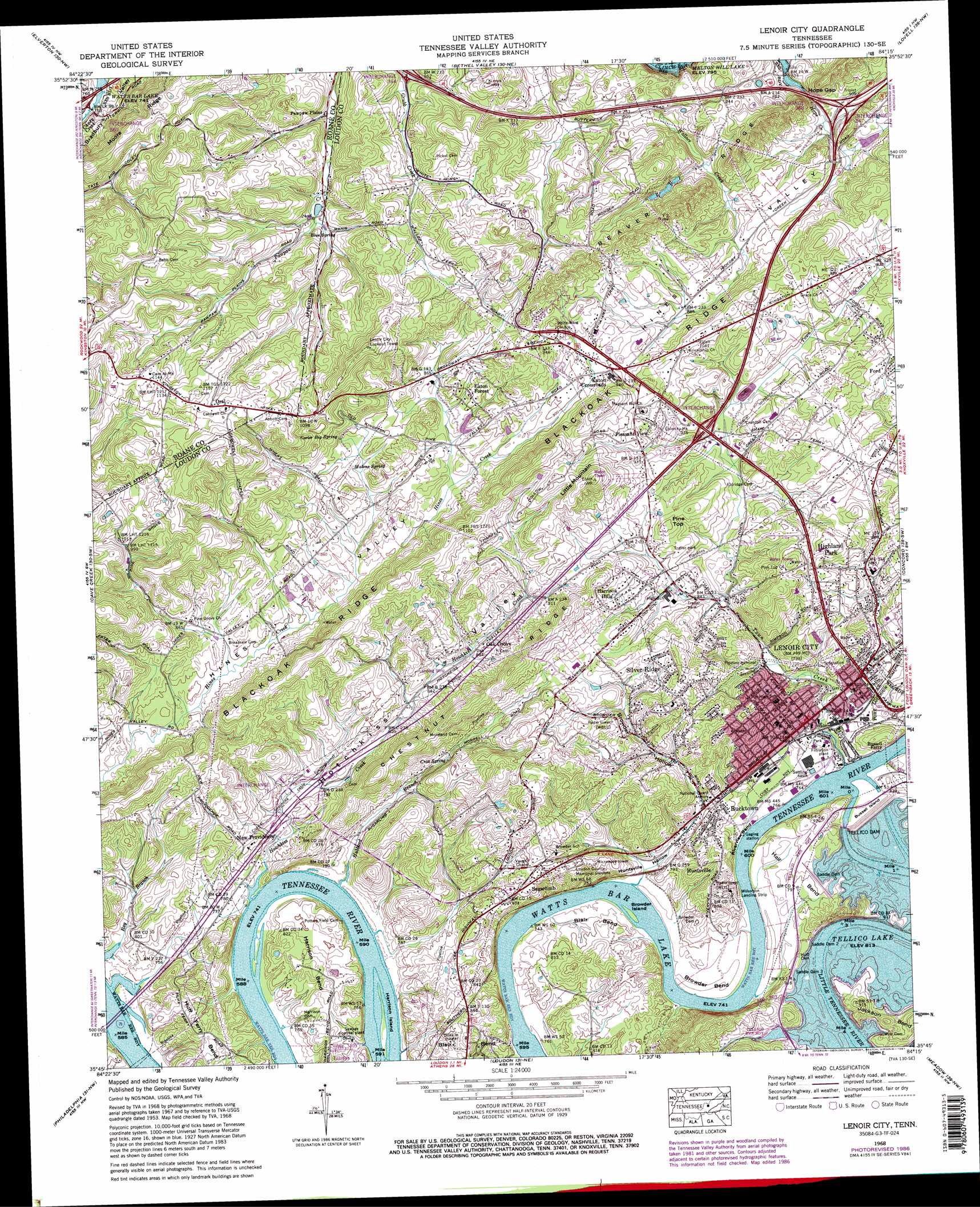
Lenoir City Topo Map Tennessee
To zoom in, hover over the map of Lenoir City
USGS Topo Quad 35084g3 - 1:24,000 scale
| Topo Map Name: | Lenoir City |
| USGS Topo Quad ID: | 35084g3 |
| Print Size: | ca. 21 1/4" wide x 27" high |
| Southeast Coordinates: | 35.75° N latitude / 84.25° W longitude |
| Map Center Coordinates: | 35.8125° N latitude / 84.3125° W longitude |
| U.S. State: | TN |
| Filename: | o35084g3.jpg |
| Download Map JPG Image: | Lenoir City topo map 1:24,000 scale |
| Map Type: | Topographic |
| Topo Series: | 7.5´ |
| Map Scale: | 1:24,000 |
| Source of Map Images: | United States Geological Survey (USGS) |
| Alternate Map Versions: |
Lenoir City TN 1935 Download PDF Buy paper map Lenoir City TN 1940 Download PDF Buy paper map Lenoir City TN 1940, updated 1952 Download PDF Buy paper map Lenoir City TN 1953, updated 1954 Download PDF Buy paper map Lenoir City TN 1953, updated 1965 Download PDF Buy paper map Lenoir City TN 1968, updated 1972 Download PDF Buy paper map Lenoir City TN 1968, updated 1977 Download PDF Buy paper map Lenoir City TN 1968, updated 1987 Download PDF Buy paper map Lenoir City TN 1968, updated 1987 Download PDF Buy paper map Lenoir City TN 2010 Download PDF Buy paper map Lenoir City TN 2013 Download PDF Buy paper map Lenoir City TN 2016 Download PDF Buy paper map |
1:24,000 Topo Quads surrounding Lenoir City
Camp Austin |
Petros |
Windrock |
Clinton |
Powell |
Harriman |
Elverton |
Bethel Valley |
Lovell |
Bearden |
Bacon Gap |
Cave Creek |
Lenoir City |
Concord |
Louisville |
Pattie Gap |
Philadelphia |
Loudon |
Meadow |
Binfield |
Niota |
Sweetwater |
Madisonville |
Vonore |
Tallassee |
> Back to 35084e1 at 1:100,000 scale
> Back to 35084a1 at 1:250,000 scale
> Back to U.S. Topo Maps home
Lenoir City topo map: Gazetteer
Lenoir City: Airports
Wilkerson Field elevation 233m 764′Lenoir City: Bars
Browder Bar elevation 226m 741′Creseys Shoals elevation 226m 741′
Lenoirs Shoals elevation 226m 741′
Loudon Shoals elevation 226m 741′
Rock Quarry Bar elevation 226m 741′
Lenoir City: Bends
Browder Bend elevation 232m 761′Hall Bend elevation 248m 813′
Harrison Bend elevation 270m 885′
Huff Ferry Bend elevation 256m 839′
Jackson Bend elevation 249m 816′
Riverview Bend elevation 233m 764′
Lenoir City: Crossings
Bussell Ferry elevation 226m 741′Hall Ferry (historical) elevation 226m 741′
Interchange 364 elevation 255m 836′
Interchange 368 elevation 243m 797′
Interchange 76 elevation 244m 800′
Interchange 81 elevation 271m 889′
Interchange 84 elevation 257m 843′
Moores Ferry (historical) elevation 226m 741′
Lenoir City: Dams
Saddle Dam 1 elevation 250m 820′Saddle Dam 2 elevation 248m 813′
Saddle Dam 3 elevation 248m 813′
Tellico Dam elevation 243m 797′
Lenoir City: Gaps
Hope Gap elevation 243m 797′Lenoir City: Islands
Browder Island elevation 226m 741′Bussell Island elevation 248m 813′
Creseys Island (historical) elevation 226m 741′
Harrison Island elevation 226m 741′
Lenoir City: Lakes
Cherrolake elevation 261m 856′Lenoir City: Parks
Lenior City Area Recreation Complex elevation 273m 895′Poplar Springs Recreation Area elevation 248m 813′
Rock Springs Park elevation 242m 793′
Rutain Park elevation 267m 875′
Lenoir City: Populated Places
Bucktown elevation 244m 800′Chestnut Ridge elevation 319m 1046′
Eaton elevation 313m 1026′
Eaton Crossroads elevation 281m 921′
Eaton Forest elevation 281m 921′
Harrison Hills elevation 286m 938′
Highland Park elevation 256m 839′
Huntsville elevation 259m 849′
Lenoir City elevation 250m 820′
New Providence elevation 241m 790′
Oak Grove elevation 266m 872′
Oral elevation 341m 1118′
Pawpaw Plains elevation 250m 820′
Pine Grove elevation 260m 853′
Pleasant View elevation 278m 912′
Sharp Estates elevation 297m 974′
Silver Ridge elevation 295m 967′
Sugarlimb elevation 275m 902′
Vancouver (historical) elevation 245m 803′
Lenoir City: Post Offices
Lenoir City Post Office elevation 240m 787′Lenoir City: Reservoirs
Tellico Lake elevation 243m 797′Lenoir City: Ridges
Chestnut Ridge elevation 281m 921′Moore Ridge elevation 354m 1161′
Saltpeter Ridge elevation 335m 1099′
Lenoir City: Springs
Blue Spring elevation 265m 869′Carter Big Spring elevation 276m 905′
Crox Spring elevation 248m 813′
Malone Spring elevation 266m 872′
Rock sjprings elevation 237m 777′
Lenoir City: Streams
Hotchkiss Creek elevation 226m 741′Hubbard Branch elevation 226m 741′
Little Tennessee River elevation 226m 741′
Town Creek elevation 229m 751′
Wallace Creek elevation 250m 820′
Lenoir City: Summits
Little Mountain elevation 372m 1220′Pine Top elevation 311m 1020′
Lenoir City: Valleys
Browder Hollow elevation 234m 767′Hotchkiss Valley elevation 227m 744′
Huntsville Hollow elevation 226m 741′
Lenoir City digital topo map on disk
Buy this Lenoir City topo map showing relief, roads, GPS coordinates and other geographical features, as a high-resolution digital map file on DVD: