Maryville Topo Map Tennessee
To zoom in, hover over the map of Maryville
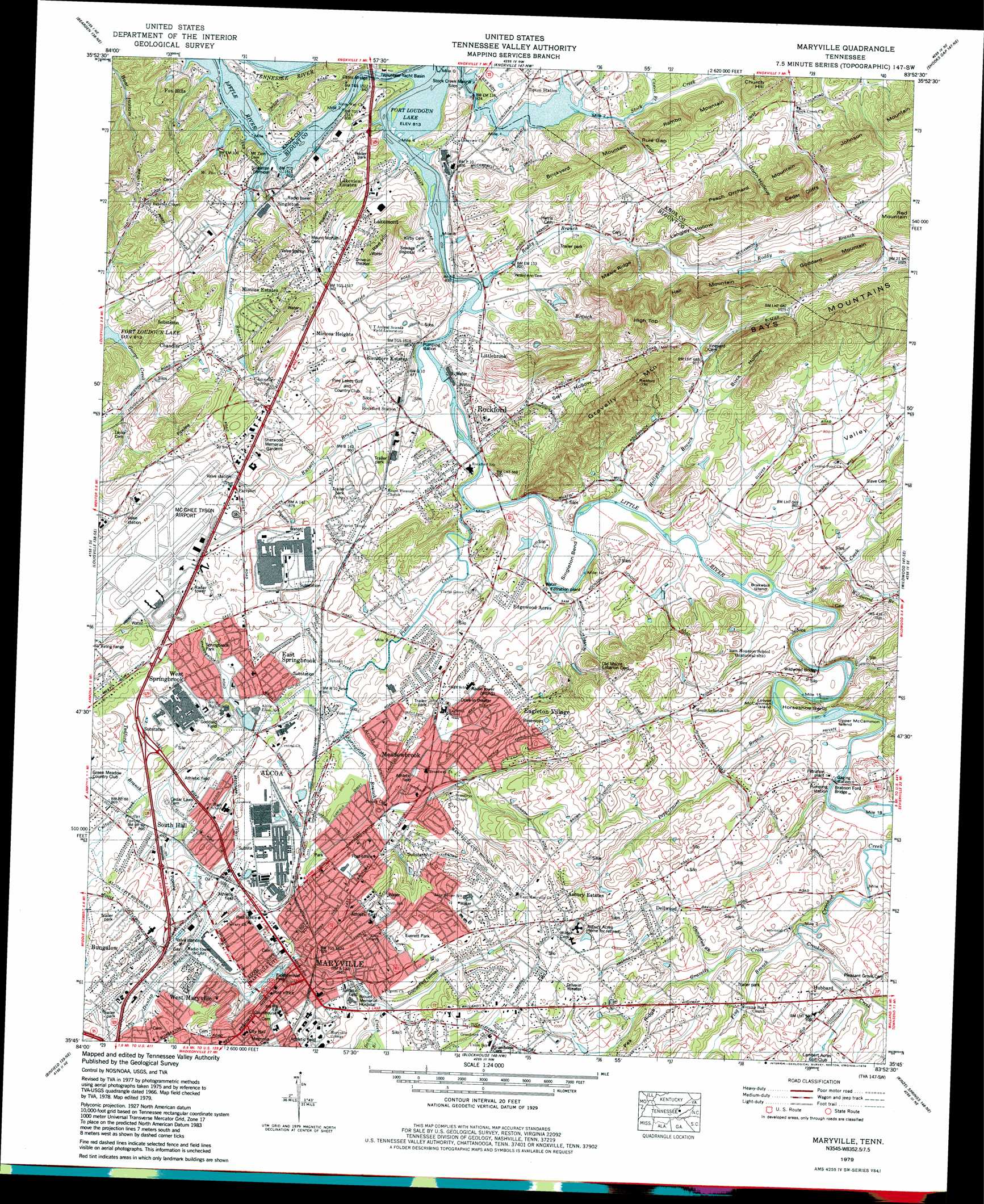
USGS Topo Quad 35083g8 - 1:24,000 scale
| Topo Map Name: | Maryville |
| USGS Topo Quad ID: | 35083g8 |
| Print Size: | ca. 21 1/4" wide x 27" high |
| Southeast Coordinates: | 35.75° N latitude / 83.875° W longitude |
| Map Center Coordinates: | 35.8125° N latitude / 83.9375° W longitude |
| U.S. State: | TN |
| Filename: | o35083g8.jpg |
| Download Map JPG Image: | Maryville topo map 1:24,000 scale |
| Map Type: | Topographic |
| Topo Series: | 7.5´ |
| Map Scale: | 1:24,000 |
| Source of Map Images: | United States Geological Survey (USGS) |
| Alternate Map Versions: |
Maryville TN 1935 Download PDF Buy paper map Maryville TN 1941 Download PDF Buy paper map Maryville TN 1941 Download PDF Buy paper map Maryville TN 1953, updated 1955 Download PDF Buy paper map Maryville TN 1953, updated 1966 Download PDF Buy paper map Maryville TN 1966, updated 1968 Download PDF Buy paper map Maryville TN 1979, updated 1979 Download PDF Buy paper map Maryville TN 1979, updated 1979 Download PDF Buy paper map Maryville TN 2010 Download PDF Buy paper map Maryville TN 2014 Download PDF Buy paper map Maryville TN 2016 Download PDF Buy paper map |
1:24,000 Topo Quads surrounding Maryville
Clinton |
Powell |
Fountain City |
John Sevier |
Mascot |
Lovell |
Bearden |
Knoxville |
Shooks Gap |
Boyds Creek |
Concord |
Louisville |
Maryville |
Wildwood |
Walden Creek |
Meadow |
Binfield |
Blockhouse |
Kinzel Springs |
Wear Cove |
Vonore |
Tallassee |
Calderwood |
Cades Cove |
Thunderhead Mountain |
> Back to 35083e1 at 1:100,000 scale
> Back to 35082a1 at 1:250,000 scale
> Back to U.S. Topo Maps home
Maryville topo map: Gazetteer
Maryville: Airports
McGhee Tyson Airport elevation 295m 967′Maryville: Bends
Horseshoe Bend elevation 272m 892′Singleton Bend elevation 251m 823′
Maryville: Bridges
Brabson Ford Bridge elevation 262m 859′Cates Bridge elevation 248m 813′
Wildwood Bridge elevation 255m 836′
Maryville: Crossings
Brabsons Ford elevation 261m 856′Maryville: Gaps
Rule Gap elevation 260m 853′Maryville: Harbors
Volunteer Yacht Basin elevation 248m 813′Maryville: Islands
Brakebill Island elevation 256m 839′Lower McCammon Island elevation 258m 846′
Upper McCammon Island elevation 260m 853′
Maryville: Parks
Alcoa Little League Park elevation 258m 846′Amerine Park elevation 315m 1033′
Bicentennial Park elevation 269m 882′
Blount County Access Area elevation 248m 813′
Central Park elevation 260m 853′
Everett Football Field elevation 303m 994′
Everett Park elevation 298m 977′
Godddard Field elevation 266m 872′
Hall Park elevation 271m 889′
Hunt Field elevation 270m 885′
John Sevier Park elevation 318m 1043′
Oldfield Park elevation 280m 918′
Rock Garden Park elevation 266m 872′
Rockford Community Park elevation 251m 823′
Springbrook Park elevation 265m 869′
Maryville: Populated Places
Airport Plaza elevation 281m 921′Alcoa elevation 257m 843′
Amerene (historical) elevation 284m 931′
Asbury Estates elevation 311m 1020′
Bank (historical) elevation 272m 892′
Bassel Addition elevation 271m 889′
Beechwood elevation 275m 902′
Belmont Addition elevation 309m 1013′
Benford Heights Addition elevation 283m 928′
Bittle Heights elevation 293m 961′
Blount Beach elevation 293m 961′
Bungalow elevation 274m 898′
Cave Mill elevation 270m 885′
Chandler elevation 272m 892′
Cherokee Park elevation 280m 918′
Dellwood elevation 308m 1010′
Duncan elevation 259m 849′
Eagleton Village elevation 289m 948′
East Springbrook elevation 272m 892′
Edgewood Acres elevation 267m 875′
Eggers Addition elevation 267m 875′
Everett Heights elevation 307m 1007′
Farrport elevation 282m 925′
Ford Addition elevation 274m 898′
Fox Hills elevation 262m 859′
Glenmore Estates elevation 274m 898′
Grandview Heights elevation 317m 1040′
Hannum Addition elevation 273m 895′
Harth Addition elevation 264m 866′
Hillsdale elevation 299m 980′
Hubbard elevation 280m 918′
Iris Acres elevation 263m 862′
Jackson Hills elevation 268m 879′
Lakemont elevation 287m 941′
Lakeview Estates elevation 272m 892′
Little River elevation 262m 859′
Littlebrook elevation 263m 862′
Maryville elevation 285m 935′
Meadowbrook elevation 265m 869′
Meadowood elevation 257m 843′
Mimosa Estates elevation 278m 912′
Mimosa Heights elevation 293m 961′
Mountain Trace elevation 292m 958′
Notime (historical) elevation 271m 889′
Oakhurst elevation 288m 944′
Oldfield Addition elevation 282m 925′
Peppermint Hills elevation 287m 941′
Plainfield elevation 279m 915′
Plainfield addition elevation 275m 902′
Rivertrace elevation 275m 902′
Rivertrace elevation 290m 951′
Rockford elevation 252m 826′
Rockgardens elevation 264m 866′
Rocky Waters elevation 277m 908′
Scenic Terrace elevation 293m 961′
Sevier Heights elevation 320m 1049′
Singleton elevation 258m 846′
South Hall elevation 269m 882′
Springbrook elevation 273m 895′
Springfield elevation 317m 1040′
Stock Creek elevation 260m 853′
Summit Hills elevation 264m 866′
Tara Estates elevation 298m 977′
Twelve Oaks elevation 303m 994′
Twin Oak Estates elevation 306m 1003′
Vose elevation 258m 846′
West Maryville elevation 271m 889′
West Springbrook elevation 272m 892′
Westfields elevation 327m 1072′
Woodmont Addition elevation 264m 866′
Maryville: Post Offices
Alcoa Post Office elevation 271m 889′Downtown Station Maryville Post Office elevation 284m 931′
Maryville Post Office elevation 265m 869′
Maryville: Springs
Chandler Spring elevation 270m 885′McTeer Spring elevation 263m 862′
Maryville: Streams
Brown Creek elevation 265m 869′Caney Branch elevation 250m 820′
Casteel Branch elevation 255m 836′
Culton Creek elevation 255m 836′
Duncan Branch elevation 283m 928′
Duncan Creek elevation 253m 830′
Dunlap Branch elevation 260m 853′
Flag Branch elevation 265m 869′
Gravelly Creek elevation 265m 869′
Hollybrook Branch elevation 251m 823′
Nails Creek elevation 253m 830′
Peppermint Branch elevation 258m 846′
Pistol Creek elevation 249m 816′
Polecat Branch elevation 248m 813′
Roddy Branch elevation 248m 813′
Russell Branch elevation 248m 813′
Springfield Branch elevation 254m 833′
Tedford Branch elevation 255m 836′
Maryville: Summits
Brickyard Mountain elevation 318m 1043′Cedar Cliffs elevation 335m 1099′
Church Hill elevation 320m 1049′
Goddard Mountain elevation 357m 1171′
Gravelly Mountain elevation 403m 1322′
Hall Mountain elevation 385m 1263′
High Top elevation 410m 1345′
Johnson Mountain elevation 359m 1177′
Maxie Ridge elevation 334m 1095′
Peach Orchard Mountain elevation 355m 1164′
Rambo Mountain elevation 336m 1102′
Red Hill elevation 332m 1089′
Maryville: Valleys
Gunn Hollow elevation 263m 862′Langley Hollow elevation 266m 872′
Self Hollow elevation 269m 882′
Tarkiln Valley elevation 253m 830′
Maryville digital topo map on disk
Buy this Maryville topo map showing relief, roads, GPS coordinates and other geographical features, as a high-resolution digital map file on DVD:
South Carolina, Western North Carolina & Northeastern Georgia
Buy digital topo maps: South Carolina, Western North Carolina & Northeastern Georgia