Ellendale Topo Map Tennessee
To zoom in, hover over the map of Ellendale
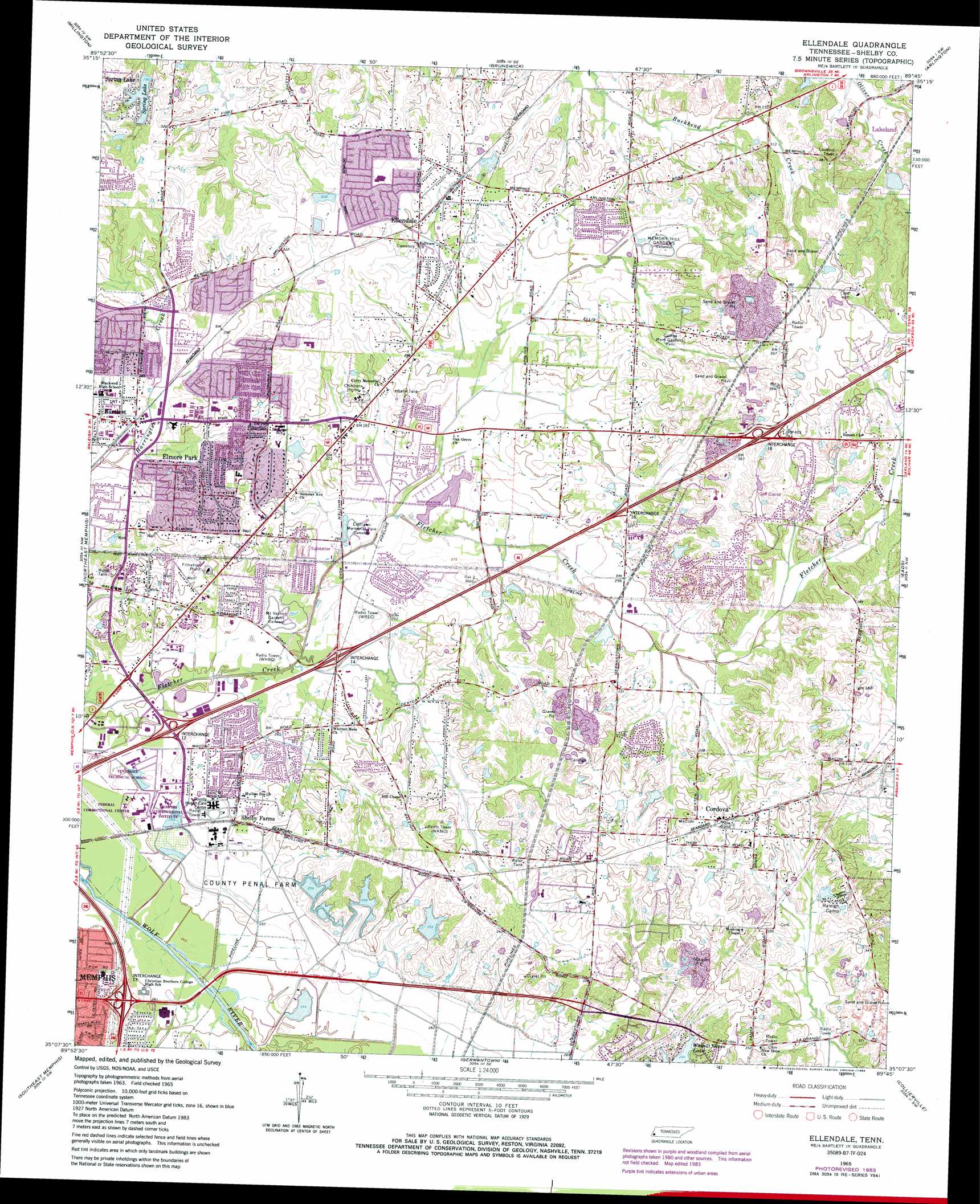
USGS Topo Quad 35089b7 - 1:24,000 scale
| Topo Map Name: | Ellendale |
| USGS Topo Quad ID: | 35089b7 |
| Print Size: | ca. 21 1/4" wide x 27" high |
| Southeast Coordinates: | 35.125° N latitude / 89.75° W longitude |
| Map Center Coordinates: | 35.1875° N latitude / 89.8125° W longitude |
| U.S. State: | TN |
| Filename: | o35089b7.jpg |
| Download Map JPG Image: | Ellendale topo map 1:24,000 scale |
| Map Type: | Topographic |
| Topo Series: | 7.5´ |
| Map Scale: | 1:24,000 |
| Source of Map Images: | United States Geological Survey (USGS) |
| Alternate Map Versions: |
Ellendale TN 1965, updated 1967 Download PDF Buy paper map Ellendale TN 1965, updated 1974 Download PDF Buy paper map Ellendale TN 1965, updated 1984 Download PDF Buy paper map Ellendale TN 1965, updated 1993 Download PDF Buy paper map Ellendale TN 1965, updated 1993 Download PDF Buy paper map Ellendale TN 2010 Download PDF Buy paper map Ellendale TN 2013 Download PDF Buy paper map Ellendale TN 2016 Download PDF Buy paper map |
1:24,000 Topo Quads surrounding Ellendale
Pecan Point |
Drummonds |
Munford |
Brighton |
Mason |
Locke |
Millington |
Brunswick |
Arlington |
Gallaway |
Northwest Memphis |
Northeast Memphis |
Ellendale |
Eads |
Oakland |
Southwest Memphis |
Southeast Memphis |
Germantown |
Collierville |
Rossville |
Horn Lake |
Pleasant Hill |
Olive Branch |
Byhalia Nw |
Mount Pleasant |
> Back to 35089a1 at 1:100,000 scale
> Back to 35088a1 at 1:250,000 scale
> Back to U.S. Topo Maps home
Ellendale topo map: Gazetteer
Ellendale: Airports
Ranger Airport elevation 79m 259′Ellendale: Crossings
Interchange 12 elevation 79m 259′Interchange 13 elevation 85m 278′
Interchange 14 elevation 82m 269′
Interchange 16 elevation 97m 318′
Interchange 18 elevation 119m 390′
Ellendale: Dams
Great American Mortgage Dam elevation 90m 295′Lakeland Sewage Pond Dam elevation 95m 311′
Penal Farm Dam Number Four elevation 80m 262′
Penal Farm Dam Number One elevation 91m 298′
Penal Farm Dam Number Three elevation 88m 288′
Penal Farm Dam Number Two elevation 91m 298′
Robinson Lake Dam elevation 88m 288′
Spring Lake Dam elevation 84m 275′
Spring Lake Dam elevation 77m 252′
Ellendale: Parks
Bartlett East Park elevation 93m 305′Bartlett Park elevation 88m 288′
Elmore Park elevation 88m 288′
Freeman Park elevation 76m 249′
Ellendale: Populated Places
Bartlett elevation 85m 278′Clay (historical) elevation 100m 328′
Cordova elevation 110m 360′
Ellendale elevation 93m 305′
Elmore Park elevation 85m 278′
Oak Grove elevation 85m 278′
Shelby Farms elevation 87m 285′
Spring Lake elevation 98m 321′
Ellendale: Post Offices
Bartlett Post Office elevation 95m 311′Cordova Post Office elevation 110m 360′
Ellendale Post Office elevation 101m 331′
Ellendale: Reservoirs
Colonial Country Club Sixteenth Hole Lake elevation 98m 321′Great American Mortgage Lake elevation 90m 295′
Lakeland Sewage Pond elevation 95m 311′
Penal Farm Lake Number Four elevation 80m 262′
Penal Farm Lake Number One elevation 91m 298′
Penal Farm Lake Number Three elevation 88m 288′
Penal Farm Lake Number Two elevation 91m 298′
Robinson Lake elevation 88m 288′
Spring Lake elevation 77m 252′
Spring Lake elevation 84m 275′
Ellendale digital topo map on disk
Buy this Ellendale topo map showing relief, roads, GPS coordinates and other geographical features, as a high-resolution digital map file on DVD: