West Point Topo Map Arkansas
To zoom in, hover over the map of West Point
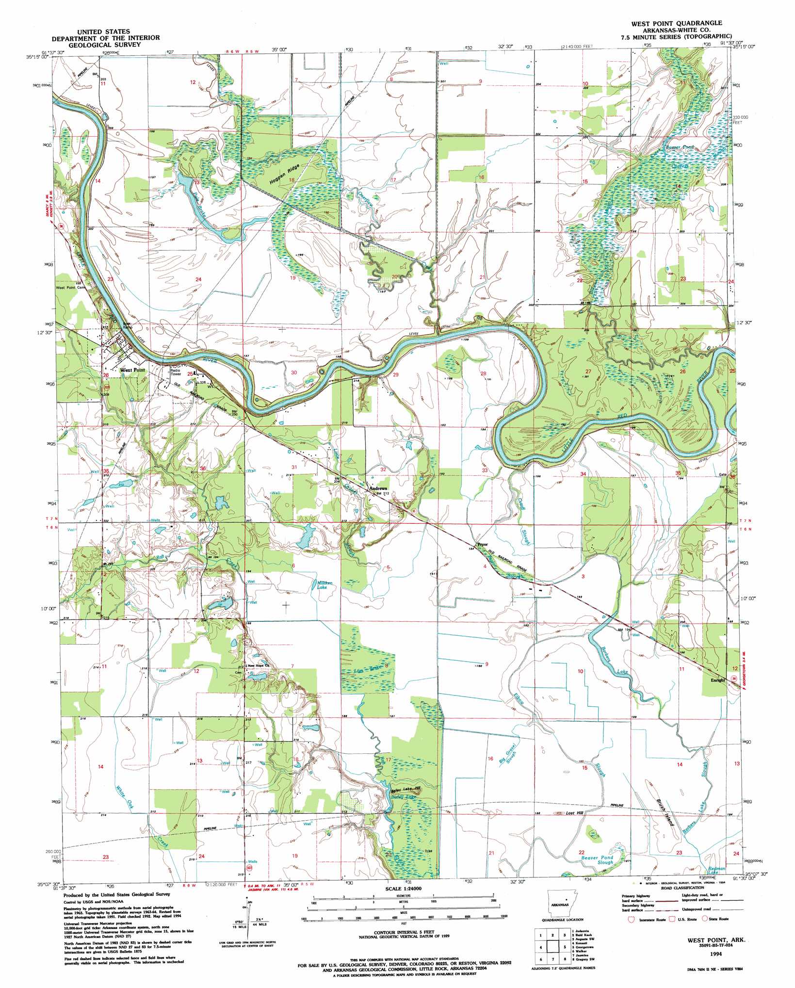
USGS Topo Quad 35091b5 - 1:24,000 scale
| Topo Map Name: | West Point |
| USGS Topo Quad ID: | 35091b5 |
| Print Size: | ca. 21 1/4" wide x 27" high |
| Southeast Coordinates: | 35.125° N latitude / 91.5° W longitude |
| Map Center Coordinates: | 35.1875° N latitude / 91.5625° W longitude |
| U.S. State: | AR |
| Filename: | o35091b5.jpg |
| Download Map JPG Image: | West Point topo map 1:24,000 scale |
| Map Type: | Topographic |
| Topo Series: | 7.5´ |
| Map Scale: | 1:24,000 |
| Source of Map Images: | United States Geological Survey (USGS) |
| Alternate Map Versions: |
West Point AR 1964, updated 1965 Download PDF Buy paper map West Point AR 1964, updated 1986 Download PDF Buy paper map West Point AR 1994, updated 1994 Download PDF Buy paper map West Point AR 2011 Download PDF Buy paper map West Point AR 2014 Download PDF Buy paper map |
1:24,000 Topo Quads surrounding West Point
Pangburn |
Steprock |
Velvet Ridge |
Bradford |
Augusta Ne |
Letona |
Judsonia |
Bald Knob |
Augusta Sw |
Augusta |
Garner |
Kensett |
West Point |
Georgetown |
Gregory |
Mcrae |
Walker |
Jasmine |
Gregory Sw |
Cotton Plant |
Wattensaw |
Hickory Plains |
Des Arc West |
Des Arc East |
De Valls Bluff Ne |
> Back to 35091a1 at 1:100,000 scale
> Back to 35090a1 at 1:250,000 scale
> Back to U.S. Topo Maps home
West Point topo map: Gazetteer
West Point: Canals
Lateral Number 10 elevation 61m 200′Lateral Number 11 elevation 62m 203′
Lateral Number 22 elevation 63m 206′
West Point: Capes
West Point elevation 62m 203′West Point: Flats
Brush Island elevation 58m 190′West Point: Guts
Crooked Slough elevation 59m 193′Pole Brake elevation 60m 196′
Taylor Slough elevation 60m 196′
West Point: Lakes
Bailey Lake elevation 58m 190′Barbers Lake elevation 58m 190′
Beaver Pond elevation 59m 193′
Milliken Lake elevation 58m 190′
Redman Lake elevation 55m 180′
West Point: Populated Places
Andrews elevation 63m 206′Barber (historical) elevation 58m 190′
Ellen (historical) elevation 66m 216′
Enright elevation 59m 193′
Pryor elevation 59m 193′
West Point elevation 62m 203′
Wranes (historical) elevation 59m 193′
West Point: Ridges
Hogpen Ridge elevation 63m 206′West Point: Streams
Barbers Lake Slough elevation 54m 177′Big Gravel Slough elevation 57m 187′
Big Mingo Creek elevation 57m 187′
Cutoff Slough elevation 58m 190′
Cypress Slough elevation 61m 200′
Elbow Slough elevation 57m 187′
Little Gravel Slough elevation 58m 190′
Overflow Creek elevation 54m 177′
West Point: Summits
Bailey Lake Hill elevation 58m 190′Lost Hill elevation 60m 196′
West Point: Swamps
Liles Brake elevation 59m 193′West Point digital topo map on disk
Buy this West Point topo map showing relief, roads, GPS coordinates and other geographical features, as a high-resolution digital map file on DVD: