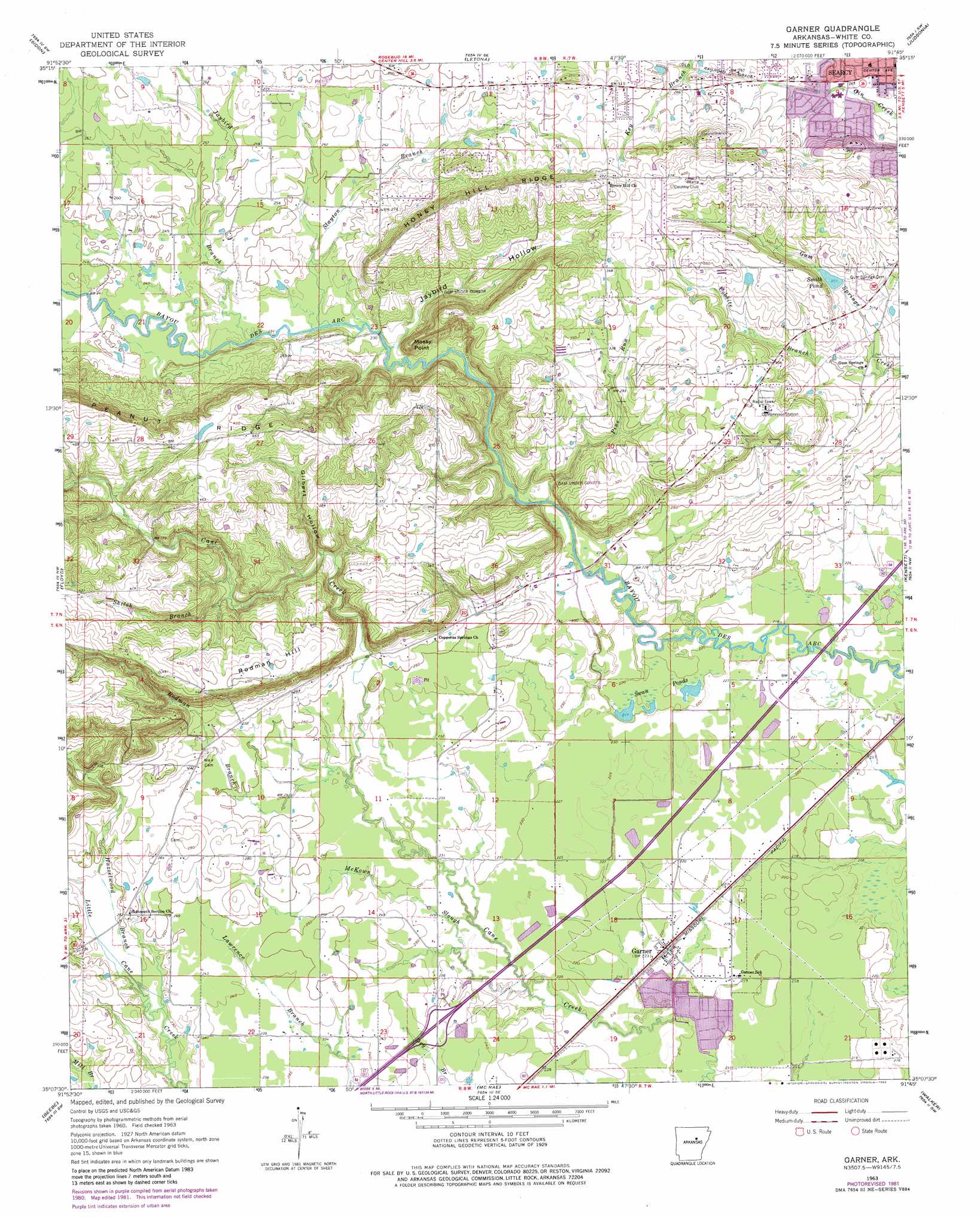
Garner Topo Map Arkansas
To zoom in, hover over the map of Garner
USGS Topo Quad 35091b7 - 1:24,000 scale
| Topo Map Name: | Garner |
| USGS Topo Quad ID: | 35091b7 |
| Print Size: | ca. 21 1/4" wide x 27" high |
| Southeast Coordinates: | 35.125° N latitude / 91.75° W longitude |
| Map Center Coordinates: | 35.1875° N latitude / 91.8125° W longitude |
| U.S. State: | AR |
| Filename: | o35091b7.jpg |
| Download Map JPG Image: | Garner topo map 1:24,000 scale |
| Map Type: | Topographic |
| Topo Series: | 7.5´ |
| Map Scale: | 1:24,000 |
| Source of Map Images: | United States Geological Survey (USGS) |
| Alternate Map Versions: |
Garner AR 1963, updated 1964 Download PDF Buy paper map Garner AR 1963, updated 1976 Download PDF Buy paper map Garner AR 1963, updated 1982 Download PDF Buy paper map Garner AR 2011 Download PDF Buy paper map Garner AR 2014 Download PDF Buy paper map |
1:24,000 Topo Quads surrounding Garner
Heber Springs |
West Pangburn |
Pangburn |
Steprock |
Velvet Ridge |
Rose Bud |
Sidon |
Letona |
Judsonia |
Bald Knob |
Mount Vernon |
Floyd |
Garner |
Kensett |
West Point |
Mountain Springs |
Beebe |
Mcrae |
Walker |
Jasmine |
Cabot |
Oak Grove |
Wattensaw |
Hickory Plains |
Des Arc West |
> Back to 35091a1 at 1:100,000 scale
> Back to 35090a1 at 1:250,000 scale
> Back to U.S. Topo Maps home
Garner topo map: Gazetteer
Garner: Airports
Honey Hill Heliport elevation 115m 377′Garner: Cliffs
Mossy Point elevation 116m 380′Garner: Dams
Lercher Lake Number One Dam elevation 143m 469′Schroeder Lake Two Dam elevation 65m 213′
Garner: Lakes
Smith Pond elevation 86m 282′Swan Ponds elevation 71m 232′
Garner: Populated Places
Garner elevation 69m 226′Jarta (historical) elevation 121m 396′
Garner: Reservoirs
Lercher Lake Number One elevation 143m 469′Schroeder Lake elevation 65m 213′
Garner: Ridges
Honey Hill Ridge elevation 137m 449′Peanut Ridge elevation 139m 456′
Garner: Streams
Cobbite Branch elevation 74m 242′Hazelwood Branch elevation 71m 232′
Jaybird Branch elevation 71m 232′
McKown Slough elevation 68m 223′
Pine Run elevation 69m 226′
Rodman Branch elevation 74m 242′
Shiloh Branch elevation 97m 318′
Slayton Branch elevation 71m 232′
Garner: Summits
Rodman Hill elevation 139m 456′Garner: Valleys
Gilbert Hollow elevation 82m 269′Jaybird Hollow elevation 73m 239′
Garner digital topo map on disk
Buy this Garner topo map showing relief, roads, GPS coordinates and other geographical features, as a high-resolution digital map file on DVD: