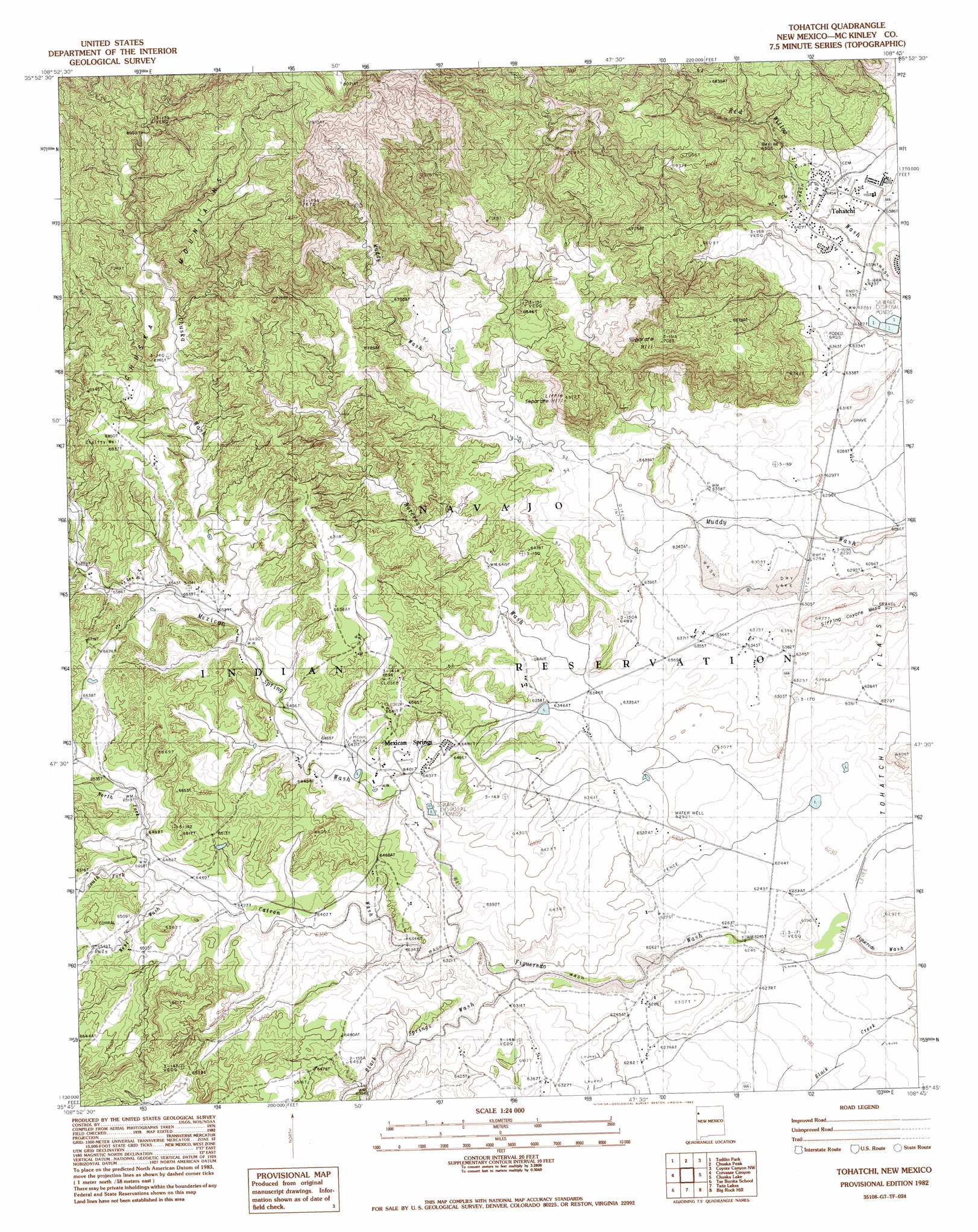
Tohatchi Topo Map New Mexico
To zoom in, hover over the map of Tohatchi
USGS Topo Quad 35108g7 - 1:24,000 scale
| Topo Map Name: | Tohatchi |
| USGS Topo Quad ID: | 35108g7 |
| Print Size: | ca. 21 1/4" wide x 27" high |
| Southeast Coordinates: | 35.75° N latitude / 108.75° W longitude |
| Map Center Coordinates: | 35.8125° N latitude / 108.8125° W longitude |
| U.S. State: | NM |
| Filename: | o35108g7.jpg |
| Download Map JPG Image: | Tohatchi topo map 1:24,000 scale |
| Map Type: | Topographic |
| Topo Series: | 7.5´ |
| Map Scale: | 1:24,000 |
| Source of Map Images: | United States Geological Survey (USGS) |
| Alternate Map Versions: |
Tohatchi NM 1982, updated 1983 Download PDF Buy paper map Tohatchi NM 2010 Download PDF Buy paper map Tohatchi NM 2013 Download PDF Buy paper map Tohatchi NM 2017 Download PDF Buy paper map |
1:24,000 Topo Quads surrounding Tohatchi
Sonsela Buttes |
Crystal |
Washington Pass |
Naschitti |
Grey Hill Spring |
Buell Park |
Todilto Park |
Chuska Peak |
Coyote Canyon Nw |
Ear Rock |
Fort Defiance |
Crevasse Canyon |
Tohatchi |
Chuska Lake |
Coyote Canyon |
Window Rock |
Tse Bonita School |
Twin Lakes |
Big Rock Hill |
Hard Ground Flats |
Hunters Point |
Samson Lake |
Gallup West |
Gallup East |
Church Rock |
> Back to 35108e1 at 1:100,000 scale
> Back to 35108a1 at 1:250,000 scale
> Back to U.S. Topo Maps home
Tohatchi topo map: Gazetteer
Tohatchi: Arroyos
Owls Nest Wash elevation 1965m 6446′South Fork Catron Wash elevation 1971m 6466′
Tohatchi: Dams
Whiskey Lake T20n Dam elevation 2200m 7217′Tohatchi: Parks
Navajo Indian Reservation Historical Marker elevation 1965m 6446′Tohatchi: Populated Places
Mexican Springs elevation 1968m 6456′Nakaibito elevation 1968m 6456′
Tohatchi elevation 1965m 6446′
Tohatchi: Post Offices
Mexican Springs Post Office elevation 1968m 6456′Tohatchi Post Office elevation 1965m 6446′
Tohatchi: Streams
Black Springs Wash elevation 1916m 6286′Catron Wash elevation 1927m 6322′
Chuska Wash elevation 1987m 6519′
Mexican Spring Wash elevation 1928m 6325′
Norcross Wash elevation 1922m 6305′
North Fork Catron Wash elevation 1972m 6469′
South Fork Catron Wash elevation 1974m 6476′
Tohatchi: Summits
Separate Hill elevation 2159m 7083′Sitting Coyote Mesa elevation 1973m 6473′
Tohatchi: Wells
14K-301 Water Well elevation 1989m 6525′14K-301A Water Well elevation 1974m 6476′
14K-315 Water Well elevation 1939m 6361′
14N-35 Water Well elevation 1951m 6400′
14T-502 Water Well elevation 1953m 6407′
14T-514 Water Well elevation 1992m 6535′
Boarding School Water Well elevation 1974m 6476′
Day School Water Well elevation 1955m 6414′
Etsitty Water Well elevation 2086m 6843′
Tohatchi digital topo map on disk
Buy this Tohatchi topo map showing relief, roads, GPS coordinates and other geographical features, as a high-resolution digital map file on DVD: