Sunset Crater East Topo Map Arizona
To zoom in, hover over the map of Sunset Crater East
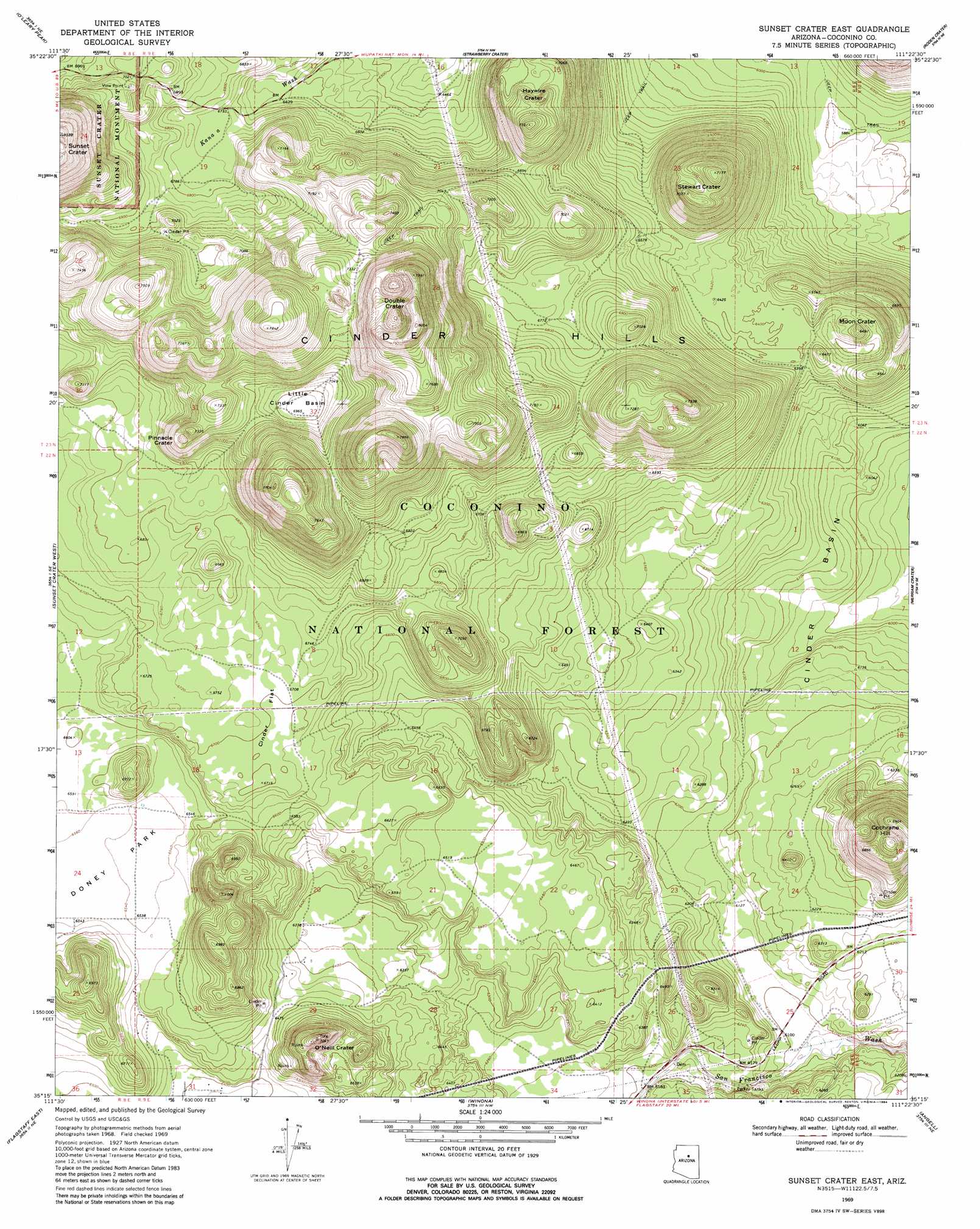
USGS Topo Quad 35111c4 - 1:24,000 scale
| Topo Map Name: | Sunset Crater East |
| USGS Topo Quad ID: | 35111c4 |
| Print Size: | ca. 21 1/4" wide x 27" high |
| Southeast Coordinates: | 35.25° N latitude / 111.375° W longitude |
| Map Center Coordinates: | 35.3125° N latitude / 111.4375° W longitude |
| U.S. State: | AZ |
| Filename: | o35111c4.jpg |
| Download Map JPG Image: | Sunset Crater East topo map 1:24,000 scale |
| Map Type: | Topographic |
| Topo Series: | 7.5´ |
| Map Scale: | 1:24,000 |
| Source of Map Images: | United States Geological Survey (USGS) |
| Alternate Map Versions: |
Sunset Crater East AZ 1969, updated 1972 Download PDF Buy paper map Sunset Crater East AZ 1969, updated 1984 Download PDF Buy paper map Sunset Crater East AZ 1969, updated 1984 Download PDF Buy paper map Sunset Crater East AZ 2011 Download PDF Buy paper map Sunset Crater East AZ 2014 Download PDF Buy paper map |
| FStopo: | US Forest Service topo Sunset Crater East is available: Download FStopo PDF Download FStopo TIF |
1:24,000 Topo Quads surrounding Sunset Crater East
S P Mountain |
East Of S P Mountain |
Wupatki Sw |
Wupatki Se |
Standing Rocks |
White Horse Hills |
O'Leary Peak |
Strawberry Crater |
Roden Crater |
Grand Falls |
Humphreys Peak |
Sunset Crater West |
Sunset Crater East |
Merriam Crater |
Grand Falls Sw |
Flagstaff West |
Flagstaff East |
Winona |
Angell |
Babbitt Wash |
Mountainaire |
Lower Lake Mary |
Ashurst Lake |
Elliott Canyon |
Anderson Canyon |
> Back to 35111a1 at 1:100,000 scale
> Back to 35110a1 at 1:250,000 scale
> Back to U.S. Topo Maps home
Sunset Crater East topo map: Gazetteer
Sunset Crater East: Basins
Cinder Basin elevation 1843m 6046′Little Cinder Basin elevation 2125m 6971′
Sunset Crater East: Craters
Double Crater elevation 2426m 7959′Haywire Crater elevation 2158m 7080′
Moon Crater elevation 1978m 6489′
O'Neill Crater elevation 2034m 6673′
Pinnacle Crater elevation 2180m 7152′
Stewart Crater elevation 2187m 7175′
Sunset Crater East: Dams
Turkey Tanks elevation 1867m 6125′Sunset Crater East: Flats
Cinder Flat elevation 2043m 6702′Sunset Crater East: Reservoirs
Browse Tank elevation 1993m 6538′Trick Tank elevation 1942m 6371′
Trick Tank elevation 1952m 6404′
Trick Tank elevation 2074m 6804′
Trick Tank elevation 2053m 6735′
Turkey Tank elevation 1878m 6161′
Sunset Crater East: Summits
Cinder Hills elevation 2097m 6879′Cochrane Hill elevation 2118m 6948′
Sunset Crater East digital topo map on disk
Buy this Sunset Crater East topo map showing relief, roads, GPS coordinates and other geographical features, as a high-resolution digital map file on DVD: