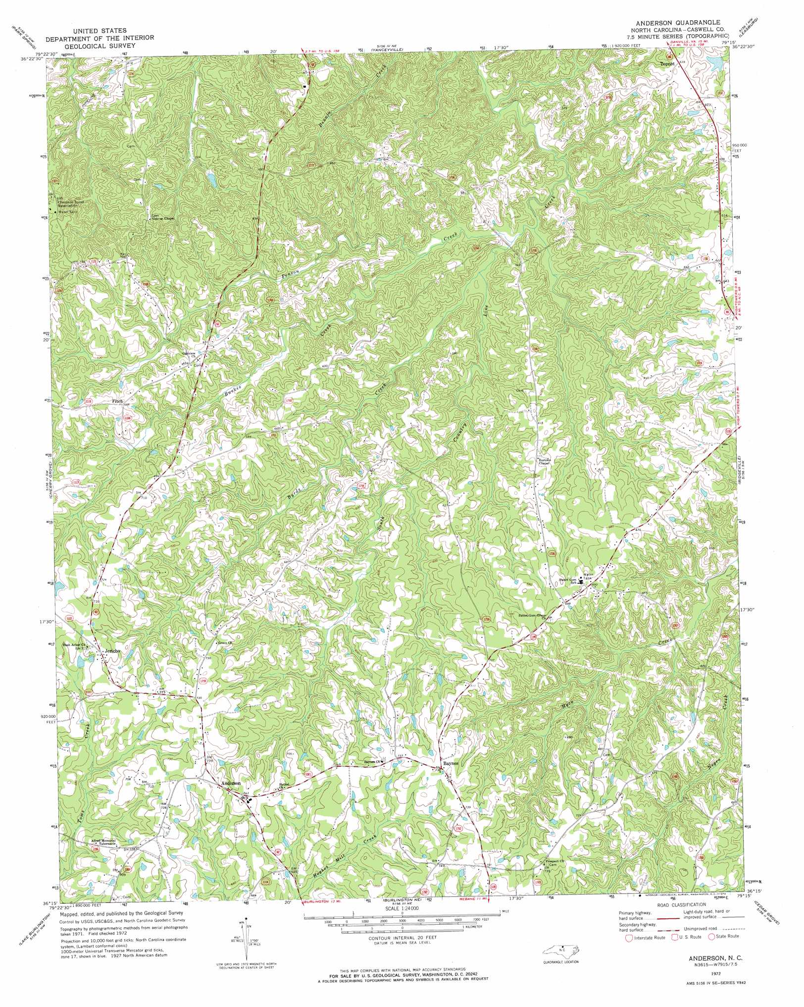
Anderson Topo Map North Carolina
To zoom in, hover over the map of Anderson
USGS Topo Quad 36079c3 - 1:24,000 scale
| Topo Map Name: | Anderson |
| USGS Topo Quad ID: | 36079c3 |
| Print Size: | ca. 21 1/4" wide x 27" high |
| Southeast Coordinates: | 36.25° N latitude / 79.25° W longitude |
| Map Center Coordinates: | 36.3125° N latitude / 79.3125° W longitude |
| U.S. State: | NC |
| Filename: | o36079c3.jpg |
| Download Map JPG Image: | Anderson topo map 1:24,000 scale |
| Map Type: | Topographic |
| Topo Series: | 7.5´ |
| Map Scale: | 1:24,000 |
| Source of Map Images: | United States Geological Survey (USGS) |
| Alternate Map Versions: |
Anderson NC 1972, updated 1974 Download PDF Buy paper map Anderson NC 2002, updated 2002 Download PDF Buy paper map Anderson NC 2010 Download PDF Buy paper map Anderson NC 2013 Download PDF Buy paper map Anderson NC 2016 Download PDF Buy paper map |
1:24,000 Topo Quads surrounding Anderson
Brosville |
Danville |
Ringgold |
Milton |
Alton |
Ruffin |
Park Spring |
Yanceyville |
Leasburg |
Olive Hill |
Williamsburg |
Cherry Grove |
Anderson |
Ridgeville |
Hurdle Mills |
Ossipee |
Lake Burlington |
Burlington Ne |
Cedar Grove |
Caldwell |
Gibsonville |
Burlington |
Mebane |
Efland |
Hillsborough |
> Back to 36079a1 at 1:100,000 scale
> Back to 36078a1 at 1:250,000 scale
> Back to U.S. Topo Maps home
Anderson topo map: Gazetteer
Anderson: Dams
Caswell Wildlife Management Pond Dam Number One elevation 174m 570′Williams Lake Dam elevation 213m 698′
Anderson: Populated Places
Anderson elevation 227m 744′Baynes elevation 224m 734′
Fitch elevation 200m 656′
Jericho elevation 218m 715′
Topnot elevation 194m 636′
Anderson: Reservoirs
Caswell Wildlife Mgmt Area Pond O elevation 174m 570′Williams Lake elevation 213m 698′
Anderson: Streams
Burkes Creek elevation 140m 459′Byrds Creek elevation 139m 456′
Penson Creek elevation 137m 449′
Anderson digital topo map on disk
Buy this Anderson topo map showing relief, roads, GPS coordinates and other geographical features, as a high-resolution digital map file on DVD:
Western Virginia & Southern West Virginia
Buy digital topo maps: Western Virginia & Southern West Virginia