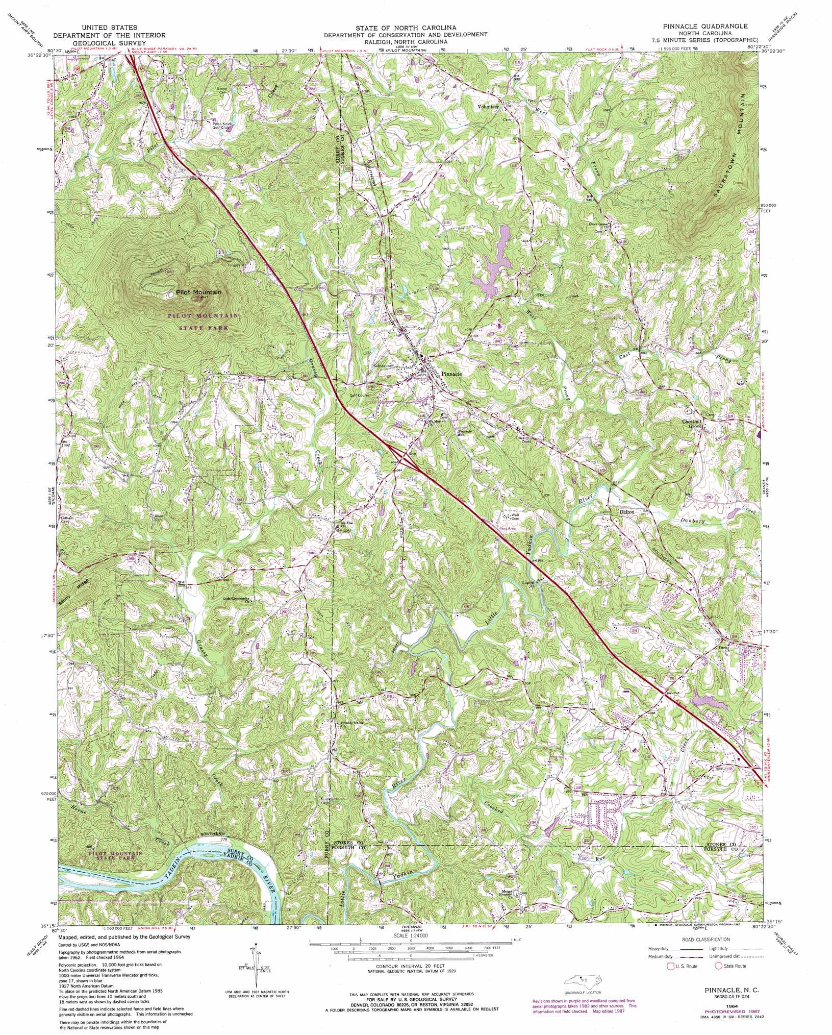
Pinnacle Topo Map North Carolina
To zoom in, hover over the map of Pinnacle
USGS Topo Quad 36080c4 - 1:24,000 scale
| Topo Map Name: | Pinnacle |
| USGS Topo Quad ID: | 36080c4 |
| Print Size: | ca. 21 1/4" wide x 27" high |
| Southeast Coordinates: | 36.25° N latitude / 80.375° W longitude |
| Map Center Coordinates: | 36.3125° N latitude / 80.4375° W longitude |
| U.S. State: | NC |
| Filename: | o36080c4.jpg |
| Download Map JPG Image: | Pinnacle topo map 1:24,000 scale |
| Map Type: | Topographic |
| Topo Series: | 7.5´ |
| Map Scale: | 1:24,000 |
| Source of Map Images: | United States Geological Survey (USGS) |
| Alternate Map Versions: |
Pinnacle NC 1964, updated 1965 Download PDF Buy paper map Pinnacle NC 1964, updated 1973 Download PDF Buy paper map Pinnacle NC 1964, updated 1987 Download PDF Buy paper map Pinnacle NC 1964, updated 1987 Download PDF Buy paper map Pinnacle NC 2010 Download PDF Buy paper map Pinnacle NC 2013 Download PDF Buy paper map Pinnacle NC 2016 Download PDF Buy paper map |
1:24,000 Topo Quads surrounding Pinnacle
Cana |
Mount Airy North |
Claudville |
Stuart Se |
Nettleridge |
Dobson |
Mount Airy South |
Pilot Mountain |
Hanging Rock |
Danbury |
Copeland |
Siloam |
Pinnacle |
King |
Walnut Cove |
Yadkinville |
East Bend |
Vienna |
Rural Hall |
Walkertown |
Lone Hickory |
Farmington |
Clemmons |
Winston-Salem West |
Winston-Salem East |
> Back to 36080a1 at 1:100,000 scale
> Back to 36080a1 at 1:250,000 scale
> Back to U.S. Topo Maps home
Pinnacle topo map: Gazetteer
Pinnacle: Crossings
McLains Ford elevation 229m 751′Pinnacle: Dams
Cox Dam elevation 256m 839′Lilly Dam elevation 281m 921′
Little Yadkin Watershed Dam Number Six elevation 293m 961′
Pinnacle: Islands
Fishing Island elevation 235m 770′Pinnacle: Parks
Pilot Mountain State Park elevation 684m 2244′Pilot Mountain State Park elevation 509m 1669′
Pinnacle Lions Park elevation 314m 1030′
Pinnacle: Populated Places
Boyden (historical) elevation 233m 764′Chestnut Grove elevation 312m 1023′
Dalton elevation 271m 889′
Pinnacle elevation 329m 1079′
Volunteer elevation 329m 1079′
Pinnacle: Post Offices
Boyden Post Office (historical) elevation 232m 761′Pinnacle: Reservoirs
Cox Lake elevation 256m 839′Lilly Lake elevation 281m 921′
Little Yadkin Watershed Lake Six elevation 293m 961′
Pinnacle: Streams
Crooked Run Creek elevation 237m 777′Danbury Creek elevation 253m 830′
East Prong Little Yadkin River elevation 260m 853′
Grassy Creek elevation 229m 751′
Horne Creek elevation 233m 764′
West Prong Little Yadkin River elevation 257m 843′
Pinnacle: Summits
Pilot Mountain elevation 731m 2398′Pinnacle digital topo map on disk
Buy this Pinnacle topo map showing relief, roads, GPS coordinates and other geographical features, as a high-resolution digital map file on DVD:
Western Virginia & Southern West Virginia
Buy digital topo maps: Western Virginia & Southern West Virginia