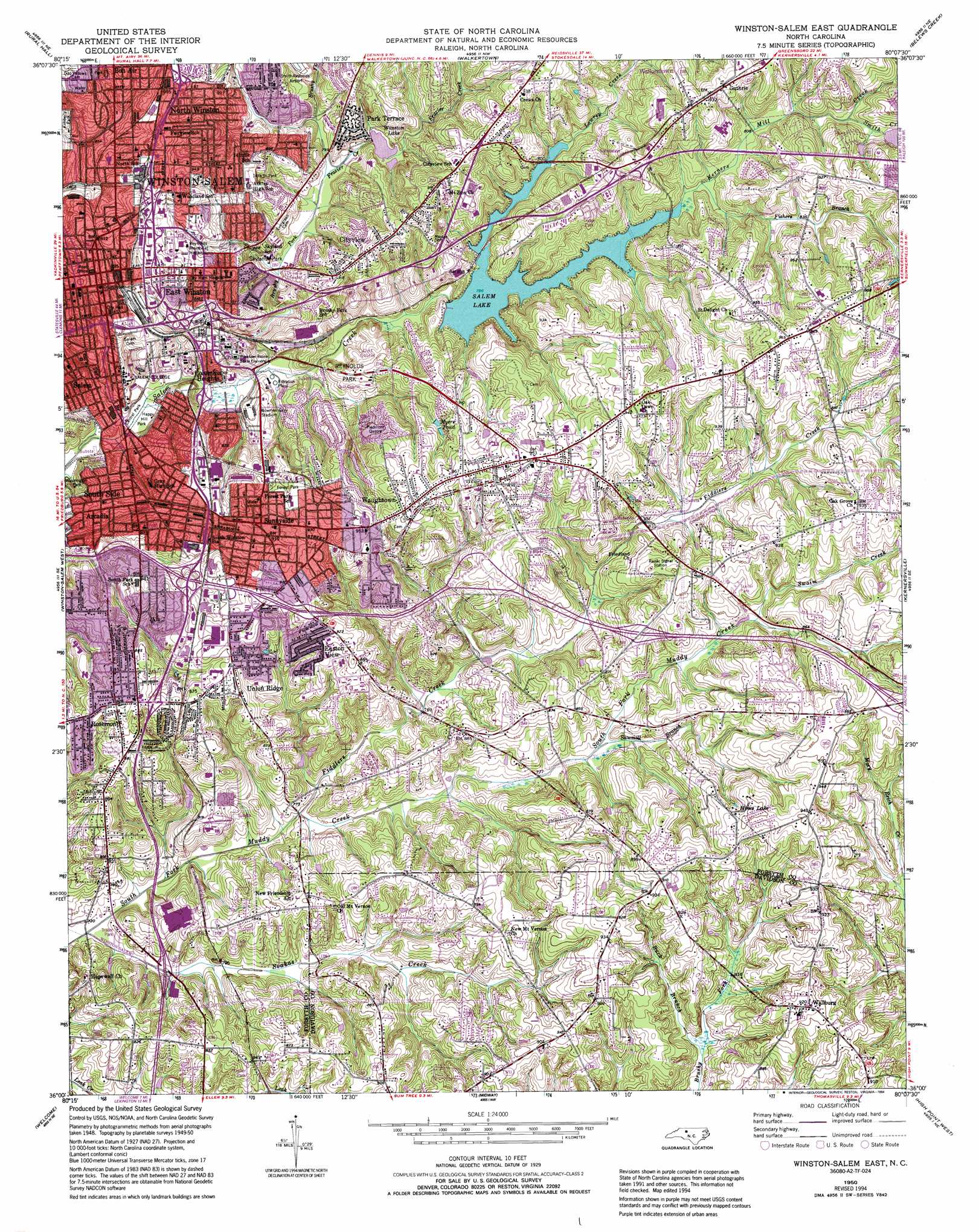
Winston-Salem East Topo Map North Carolina
To zoom in, hover over the map of Winston-Salem East
USGS Topo Quad 36080a2 - 1:24,000 scale
| Topo Map Name: | Winston-Salem East |
| USGS Topo Quad ID: | 36080a2 |
| Print Size: | ca. 21 1/4" wide x 27" high |
| Southeast Coordinates: | 36° N latitude / 80.125° W longitude |
| Map Center Coordinates: | 36.0625° N latitude / 80.1875° W longitude |
| U.S. State: | NC |
| Filename: | o36080a2.jpg |
| Download Map JPG Image: | Winston-Salem East topo map 1:24,000 scale |
| Map Type: | Topographic |
| Topo Series: | 7.5´ |
| Map Scale: | 1:24,000 |
| Source of Map Images: | United States Geological Survey (USGS) |
| Alternate Map Versions: |
Winston-Salem East NC 1950, updated 1965 Download PDF Buy paper map Winston-Salem East NC 1950, updated 1971 Download PDF Buy paper map Winston-Salem East NC 1950, updated 1973 Download PDF Buy paper map Winston-Salem East NC 1950, updated 1987 Download PDF Buy paper map Winston-Salem East NC 1950, updated 1994 Download PDF Buy paper map Winston-Salem East NC 1951 Download PDF Buy paper map Winston-Salem East NC 1977, updated 1979 Download PDF Buy paper map Winston-Salem East NC 1997, updated 2001 Download PDF Buy paper map Winston-Salem East NC 2010 Download PDF Buy paper map Winston-Salem East NC 2013 Download PDF Buy paper map Winston-Salem East NC 2016 Download PDF Buy paper map |
1:24,000 Topo Quads surrounding Winston-Salem East
Pinnacle |
King |
Walnut Cove |
Belews Lake |
Ellisboro |
Vienna |
Rural Hall |
Walkertown |
Belews Creek |
Summerfield |
Clemmons |
Winston-Salem West |
Winston-Salem East |
Kernersville |
Guilford |
Advance |
Welcome |
Midway |
High Point West |
High Point East |
Churchland |
Lexington West |
Lexington East |
Fair Grove |
Glenola |
> Back to 36080a1 at 1:100,000 scale
> Back to 36080a1 at 1:250,000 scale
> Back to U.S. Topo Maps home
Winston-Salem East topo map: Gazetteer
Winston-Salem East: Airports
Blevins Airport elevation 283m 928′Winston-Salem East: Basins
Piedmont Quarry elevation 241m 790′Winston-Salem East: Dams
Lower Angel Lake Dam elevation 254m 833′Nichols Lake Dam elevation 271m 889′
Salem Lake Dam elevation 236m 774′
Winston Lake Dam elevation 246m 807′
Winston-Salem East: Lakes
Hines Lake elevation 277m 908′Winston-Salem East: Parks
Blum Park elevation 276m 905′Bowman-Gray Stadium elevation 242m 793′
Central Park elevation 230m 754′
Central Park Pool elevation 229m 751′
Civitan Park elevation 233m 764′
Forest Park elevation 276m 905′
Fourteenth Street Park elevation 269m 882′
Happy Hill Park elevation 229m 751′
Reynolds Park elevation 255m 836′
Skyland Park elevation 236m 774′
Sprague Street Park elevation 278m 912′
Washington Park elevation 236m 774′
Winston-Salem East: Populated Places
Arcadia elevation 257m 843′Cityview elevation 276m 905′
Columbia Heights elevation 265m 869′
East Winston elevation 282m 925′
Easton View elevation 281m 921′
Four Seasons elevation 258m 846′
Glen High Estates elevation 264m 866′
Guthrie elevation 283m 928′
Holly Acres elevation 264m 866′
Merriweather Estates elevation 286m 938′
Morningside Manor elevation 284m 931′
North Winston elevation 294m 964′
Park Terrace elevation 259m 849′
Rolling Acres elevation 258m 846′
Rosemont elevation 282m 925′
Salem elevation 248m 813′
Sedge Garden elevation 290m 951′
Shalimar elevation 250m 820′
Skyview Park elevation 269m 882′
South Side elevation 260m 853′
Sunnyside elevation 278m 912′
Union Ridge elevation 276m 905′
Wallburg elevation 280m 918′
Waughtown elevation 287m 941′
Willowbend elevation 280m 918′
Winston-Salem elevation 278m 912′
Woodbridge elevation 259m 849′
Winston-Salem East: Post Offices
Winston-Salem Post Office elevation 285m 935′Winston-Salem East: Reservoirs
Lower Angel Lake elevation 254m 833′Myers Pond elevation 264m 866′
Nichols Lake elevation 271m 889′
Salem Lake elevation 236m 774′
Winston Lake elevation 246m 807′
Winston-Salem East: Streams
Brushy Fork elevation 232m 761′Brushy Fork Branch elevation 250m 820′
Buck Branch elevation 241m 790′
Fiddlers Creek elevation 225m 738′
Fishers Branch elevation 244m 800′
Frazier Creek elevation 239m 784′
Hartman Branch elevation 225m 738′
Kerners Mill Creek elevation 242m 793′
Lowery Mill Creek elevation 242m 793′
Martin Mill Creek elevation 247m 810′
Sawmill Branch elevation 237m 777′
Smith Creek elevation 250m 820′
Soakas Creek elevation 219m 718′
Swaim Creek elevation 248m 813′
Tar Branch elevation 230m 754′
Winston-Salem East digital topo map on disk
Buy this Winston-Salem East topo map showing relief, roads, GPS coordinates and other geographical features, as a high-resolution digital map file on DVD:
Western Virginia & Southern West Virginia
Buy digital topo maps: Western Virginia & Southern West Virginia