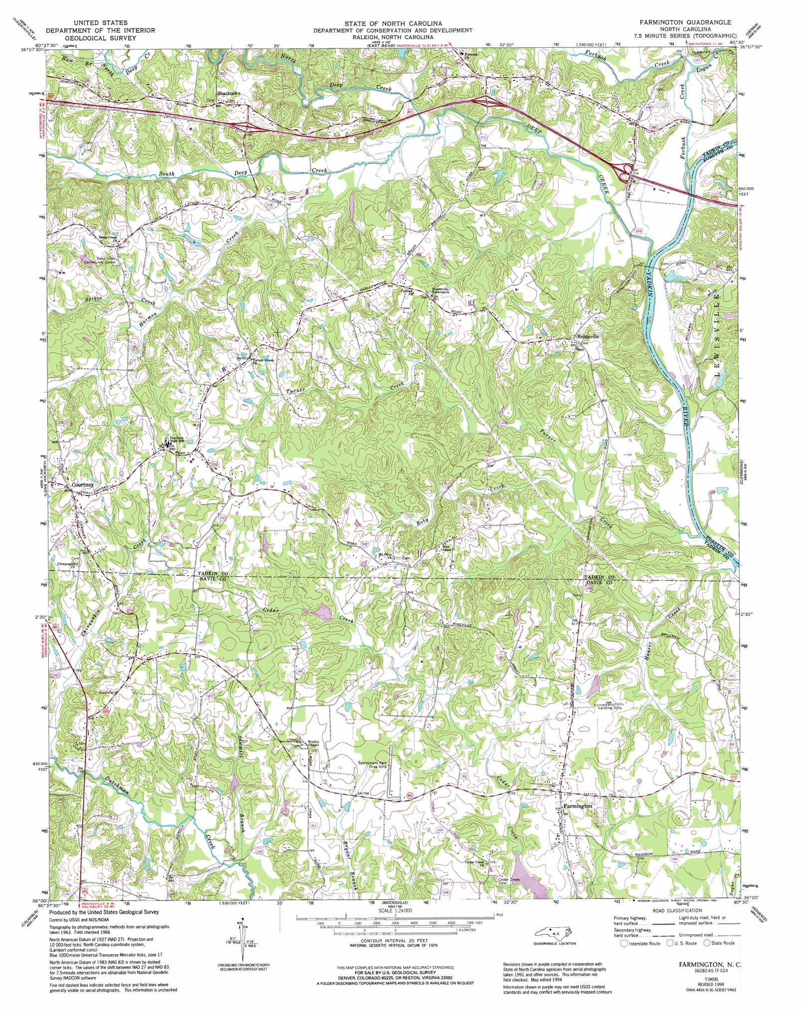
Farmington Topo Map North Carolina
To zoom in, hover over the map of Farmington
USGS Topo Quad 36080a5 - 1:24,000 scale
| Topo Map Name: | Farmington |
| USGS Topo Quad ID: | 36080a5 |
| Print Size: | ca. 21 1/4" wide x 27" high |
| Southeast Coordinates: | 36° N latitude / 80.5° W longitude |
| Map Center Coordinates: | 36.0625° N latitude / 80.5625° W longitude |
| U.S. State: | NC |
| Filename: | o36080a5.jpg |
| Download Map JPG Image: | Farmington topo map 1:24,000 scale |
| Map Type: | Topographic |
| Topo Series: | 7.5´ |
| Map Scale: | 1:24,000 |
| Source of Map Images: | United States Geological Survey (USGS) |
| Alternate Map Versions: |
Farmington NC 1966, updated 1967 Download PDF Buy paper map Farmington NC 1966, updated 1994 Download PDF Buy paper map Farmington NC 2010 Download PDF Buy paper map Farmington NC 2013 Download PDF Buy paper map Farmington NC 2016 Download PDF Buy paper map |
1:24,000 Topo Quads surrounding Farmington
Elkin North |
Copeland |
Siloam |
Pinnacle |
King |
Elkin South |
Yadkinville |
East Bend |
Vienna |
Rural Hall |
Brooks Crossroads |
Lone Hickory |
Farmington |
Clemmons |
Winston-Salem West |
Harmony |
Calahaln |
Mocksville |
Advance |
Welcome |
Statesville East |
Cool Springs |
Cooleemee |
Churchland |
Lexington West |
> Back to 36080a1 at 1:100,000 scale
> Back to 36080a1 at 1:250,000 scale
> Back to U.S. Topo Maps home
Farmington topo map: Gazetteer
Farmington: Airports
Shallowford Airport elevation 216m 708′Farmington: Crossings
Shallow Ford elevation 212m 695′Farmington: Dams
Danials-Davis Dam elevation 218m 715′Marshall Dam elevation 233m 764′
Whip-O-Will Farms Number One Dam elevation 223m 731′
Farmington: Mines
Dixon Mine elevation 257m 843′Gross Mine elevation 263m 862′
Farmington: Populated Places
Cedar Forest Estates elevation 228m 748′Courtney elevation 275m 902′
Farmington elevation 239m 784′
Four Corners elevation 267m 875′
Huntsville elevation 263m 862′
Pino elevation 243m 797′
Shacktown elevation 262m 859′
Wyo elevation 255m 836′
Farmington: Post Offices
Nestor Post Office elevation 262m 859′Pino Post Office elevation 242m 793′
Farmington: Reservoirs
Cedar Creek Lake elevation 218m 715′Marshall Lake elevation 233m 764′
Whip-O-Will Farms Number One Lake elevation 223m 731′
Farmington: Streams
Caudle Branch elevation 211m 692′Chinquapin Creek elevation 220m 721′
Deep Creek elevation 213m 698′
Forbush Creek elevation 213m 698′
Harmon Creek elevation 220m 721′
Hauser Creek elevation 210m 688′
Haw Branch elevation 243m 797′
Logan Creek elevation 216m 708′
North Deep Creek elevation 217m 711′
Roby Creek elevation 214m 702′
Sawmill Branch elevation 214m 702′
South Deep Creek elevation 217m 711′
Spiker Creek elevation 238m 780′
Turner Creek elevation 210m 688′
Farmington digital topo map on disk
Buy this Farmington topo map showing relief, roads, GPS coordinates and other geographical features, as a high-resolution digital map file on DVD:
Western Virginia & Southern West Virginia
Buy digital topo maps: Western Virginia & Southern West Virginia