Bluff City Topo Map Tennessee
To zoom in, hover over the map of Bluff City
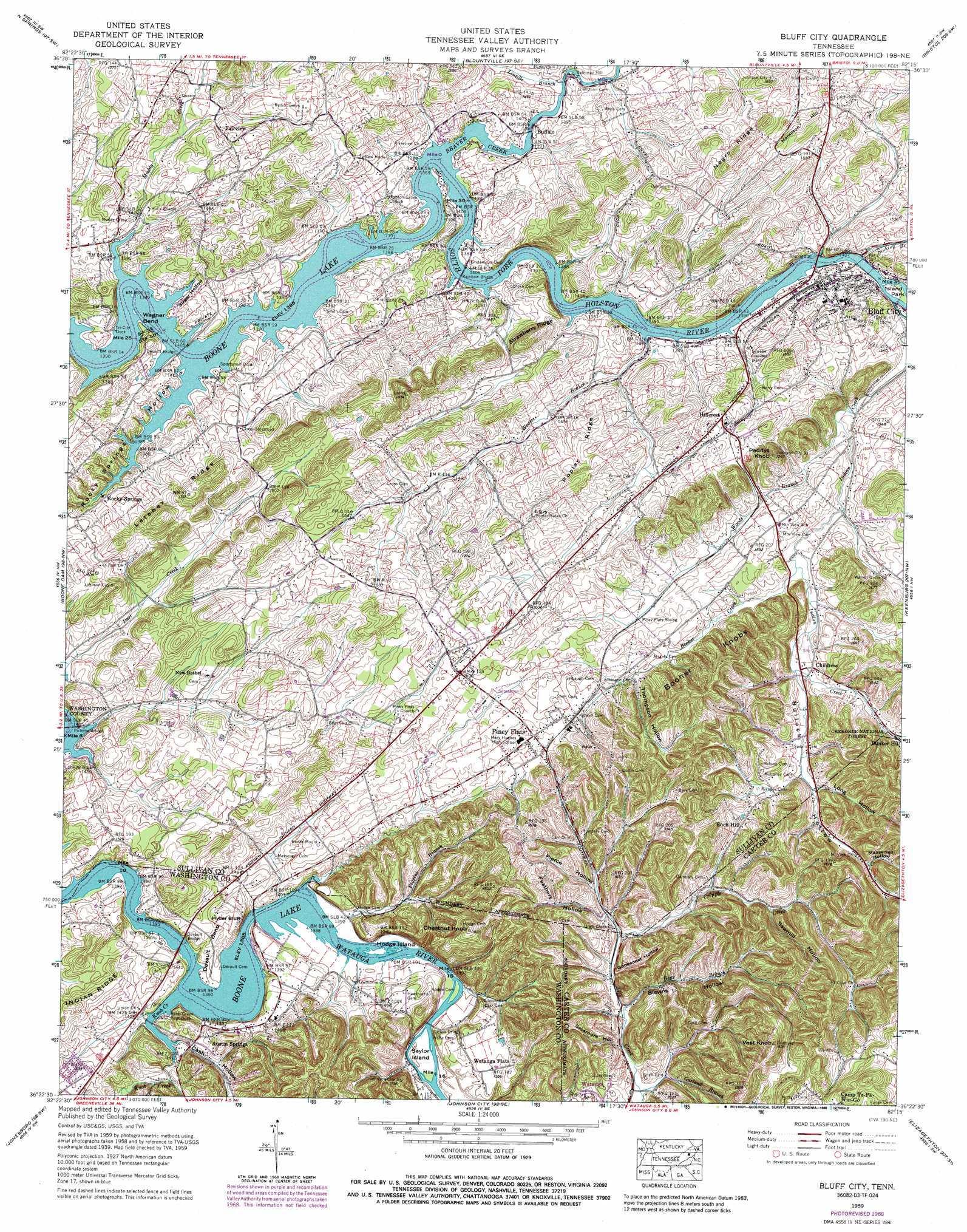
USGS Topo Quad 36082d3 - 1:24,000 scale
| Topo Map Name: | Bluff City |
| USGS Topo Quad ID: | 36082d3 |
| Print Size: | ca. 21 1/4" wide x 27" high |
| Southeast Coordinates: | 36.375° N latitude / 82.25° W longitude |
| Map Center Coordinates: | 36.4375° N latitude / 82.3125° W longitude |
| U.S. State: | TN |
| Filename: | o36082d3.jpg |
| Download Map JPG Image: | Bluff City topo map 1:24,000 scale |
| Map Type: | Topographic |
| Topo Series: | 7.5´ |
| Map Scale: | 1:24,000 |
| Source of Map Images: | United States Geological Survey (USGS) |
| Alternate Map Versions: |
Bluff City TN 1935 Download PDF Buy paper map Bluff City TN 1939, updated 1954 Download PDF Buy paper map Bluff City TN 1940 Download PDF Buy paper map Bluff City TN 1959, updated 1962 Download PDF Buy paper map Bluff City TN 1959, updated 1971 Download PDF Buy paper map Bluff City TN 1959, updated 1988 Download PDF Buy paper map Bluff City TN 2011 Download PDF Buy paper map Bluff City TN 2013 Download PDF Buy paper map Bluff City TN 2016 Download PDF Buy paper map |
| FStopo: | US Forest Service topo Bluff City is available: Download FStopo PDF Download FStopo TIF |
1:24,000 Topo Quads surrounding Bluff City
Gate City |
Hilton |
Mendota |
Wallace |
Wyndale |
Kingsport |
Indian Springs |
Blountville |
Bristol |
Holston Valley |
Sullivan Gardens |
Boone Dam |
Bluff City |
Keenburg |
Carter |
Leesburg |
Jonesboro |
Johnson City |
Elizabethton |
Watauga Dam |
Telford |
Erwin |
Unicoi |
Iron Mountain Gap |
White Rocks Mountain |
> Back to 36082a1 at 1:100,000 scale
> Back to 36082a1 at 1:250,000 scale
> Back to U.S. Topo Maps home
Bluff City topo map: Gazetteer
Bluff City: Airports
PCC Helipad elevation 444m 1456′Bluff City: Bends
Devault Bend elevation 440m 1443′Indian Bend elevation 430m 1410′
Wagner Bend elevation 423m 1387′
Bluff City: Bridges
Devault Bridge elevation 422m 1384′Devault Bridge elevation 422m 1384′
Gibson Bridge elevation 425m 1394′
Hyder Bluff Bridge elevation 422m 1384′
Pickens Bridge elevation 422m 1384′
Rainbow Bridge elevation 422m 1384′
Bluff City: Cliffs
Hyder Bluff elevation 422m 1384′Bluff City: Crossings
Devault Ford (historical) elevation 422m 1384′Sturgeon Ford (historical) elevation 422m 1384′
Bluff City: Islands
Fickles Island (historical) elevation 422m 1384′Hodge Island elevation 423m 1387′
Massengill Island (historical) elevation 422m 1384′
Saylor Island elevation 425m 1394′
Stoney Cross Island (historical) elevation 422m 1384′
Bluff City: Parks
Island Park elevation 422m 1384′Bluff City: Populated Places
Austin Springs elevation 454m 1489′Bluff City elevation 442m 1450′
Buffalo elevation 426m 1397′
Childress elevation 450m 1476′
Fairview elevation 468m 1535′
Galloway Mill elevation 430m 1410′
Green Valley elevation 457m 1499′
Gross Crossroad elevation 462m 1515′
Hamilton elevation 463m 1519′
Hillcrest elevation 469m 1538′
Lella (historical) elevation 422m 1384′
New Bethel elevation 470m 1541′
Piney Flats elevation 477m 1564′
Rock Hill elevation 477m 1564′
Rocky Springs elevation 436m 1430′
S And D Mobile Home Park elevation 461m 1512′
Sumpter (historical) elevation 435m 1427′
Thom (historical) elevation 452m 1482′
Watauga Flats elevation 464m 1522′
Bluff City: Post Offices
Piney Flats Post Office elevation 480m 1574′Bluff City: Ridges
Booher Knobs elevation 556m 1824′Letcher Ridge elevation 520m 1706′
Negro Ridge elevation 524m 1719′
Poplar Ridge elevation 495m 1624′
Bluff City: Streams
Apache Creek elevation 443m 1453′Bear Branch elevation 437m 1433′
Beaver Creek elevation 422m 1384′
Beaver Creek elevation 422m 1384′
Booher Creek elevation 440m 1443′
Cobb Creek elevation 440m 1443′
Cripple Creek elevation 439m 1440′
Figgins Branch elevation 423m 1387′
Garland Branch elevation 437m 1433′
Hogan Branch elevation 422m 1384′
Indian Creek elevation 422m 1384′
Knob Creek elevation 422m 1384′
Lick Branch elevation 437m 1433′
Linville Branch elevation 432m 1417′
Massengill Branch elevation 422m 1384′
Muddy Creek elevation 422m 1384′
Sinking Branch elevation 425m 1394′
Weaver Branch elevation 431m 1414′
Woods Branch elevation 431m 1414′
Bluff City: Summits
Chestnut Knob elevation 580m 1902′Hamilton Hill elevation 514m 1686′
Paddys Knob elevation 532m 1745′
Rocky Mount elevation 470m 1541′
Strawberry Ridge elevation 504m 1653′
Strawberry Top elevation 522m 1712′
Vest Knob elevation 577m 1893′
Bluff City: Valleys
Bear Hollow elevation 450m 1476′Blevins Hollow elevation 438m 1437′
Bullock Hollow elevation 443m 1453′
Carr Hollow elevation 451m 1479′
Cash Hollow elevation 422m 1384′
Feathers Hollow elevation 445m 1459′
Goosenest Hollow elevation 441m 1446′
Harry Hollow elevation 450m 1476′
Humphreys Hollow elevation 444m 1456′
Long Hollow elevation 455m 1492′
Massengill Hollow elevation 461m 1512′
Pierce Hollow elevation 450m 1476′
Rocky Springs Hollow elevation 422m 1384′
Sawmill Hollow elevation 456m 1496′
Shell Hollow elevation 437m 1433′
Sugar Hollow elevation 422m 1384′
Sycamore Hollow elevation 437m 1433′
Thompson Hollow elevation 462m 1515′
Wagner Hollow elevation 442m 1450′
Bluff City digital topo map on disk
Buy this Bluff City topo map showing relief, roads, GPS coordinates and other geographical features, as a high-resolution digital map file on DVD:
Western Virginia & Southern West Virginia
Buy digital topo maps: Western Virginia & Southern West Virginia