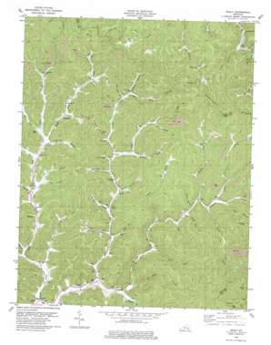
Scalf Topo Map Kentucky
To zoom in, hover over the map of Scalf
USGS Topo Quad 36083h6 - 1:24,000 scale
| Topo Map Name: | Scalf |
| USGS Topo Quad ID: | 36083h6 |
| Print Size: | ca. 21 1/4" wide x 27" high |
| Southeast Coordinates: | 36.875° N latitude / 83.625° W longitude |
| Map Center Coordinates: | 36.9375° N latitude / 83.6875° W longitude |
| U.S. State: | KY |
| Filename: | o36083h6.jpg |
| Download Map JPG Image: | Scalf topo map 1:24,000 scale |
| Map Type: | Topographic |
| Topo Series: | 7.5´ |
| Map Scale: | 1:24,000 |
| Source of Map Images: | United States Geological Survey (USGS) |
| Alternate Map Versions: |
Scalf KY 1954, updated 1956 Download PDF Buy paper map Scalf KY 1954, updated 1971 Download PDF Buy paper map Scalf KY 1979, updated 1979 Download PDF Buy paper map Scalf KY 2011 Download PDF Buy paper map Scalf KY 2013 Download PDF Buy paper map Scalf KY 2016 Download PDF Buy paper map |
| FStopo: | US Forest Service topo Scalf is available: Download FStopo PDF Download FStopo TIF |
1:24,000 Topo Quads surrounding Scalf
> Back to 36083e1 at 1:100,000 scale
> Back to 36082a1 at 1:250,000 scale
> Back to U.S. Topo Maps home
Scalf topo map: Gazetteer
Scalf: Gaps
Caney Gap elevation 360m 1181′Clay Gap elevation 456m 1496′
Greasy Gap elevation 516m 1692′
Scalf: Populated Places
Dewitt elevation 300m 984′Hammond elevation 315m 1033′
Scalf elevation 322m 1056′
Walker elevation 306m 1003′
Scalf: Post Offices
Barnyard Post Office (historical) elevation 307m 1007′Caudill Post Office (historical) elevation 324m 1062′
Cave Rock Post Office (historical) elevation 346m 1135′
Dewitt Post Office elevation 300m 984′
Mills Post Office (historical) elevation 343m 1125′
Salt Gum Post Office (historical) elevation 327m 1072′
Scalf Post Office elevation 320m 1049′
Smallwood Post Office (historical) elevation 318m 1043′
Walker Post Office elevation 320m 1049′
Scalf: Streams
Acorn Fork elevation 337m 1105′Bailey Branch elevation 325m 1066′
Bell Fork elevation 310m 1017′
Big Beech Branch elevation 316m 1036′
Big Shady Branch elevation 322m 1056′
Bingham Branch elevation 322m 1056′
Bob Bargo Branch elevation 336m 1102′
Brices Creek elevation 300m 984′
Browns Branch elevation 307m 1007′
Buckeye Fork elevation 330m 1082′
Burnt House Branch elevation 324m 1062′
Camel Branch elevation 327m 1072′
Clark Branch elevation 304m 997′
Coles Branch elevation 305m 1000′
Dora Branch elevation 310m 1017′
Grubb Branch elevation 329m 1079′
Hale Fork elevation 300m 984′
Henry Branch elevation 327m 1072′
Hinkle Branch elevation 304m 997′
Hog Branch elevation 338m 1108′
Hubbard Branch elevation 311m 1020′
Hurricane Branch elevation 311m 1020′
Jeff Creek elevation 314m 1030′
Johns Branch elevation 308m 1010′
Kinningham Branch elevation 308m 1010′
Laurel Creek elevation 324m 1062′
Little Beech Branch elevation 316m 1036′
Lost Fork elevation 312m 1023′
Macroe Branch elevation 314m 1030′
Meadow Branch elevation 301m 987′
Middle Fork Stinking Creek elevation 301m 987′
Mills Creek elevation 310m 1017′
Parkers Branch elevation 310m 1017′
Road Fork Creek elevation 300m 984′
Roaring Fork elevation 304m 997′
Salt Gum Creek elevation 317m 1040′
Shingle Roof Branch elevation 326m 1069′
Trace Branch elevation 340m 1115′
Tuggle Fork elevation 365m 1197′
Turkey Fork elevation 325m 1066′
Waterfall Branch elevation 326m 1069′
Scalf: Summits
Huckleberry Knob elevation 583m 1912′The Three Knobs elevation 611m 2004′
Scalf: Valleys
Abe Hollow elevation 331m 1085′Scalf digital topo map on disk
Buy this Scalf topo map showing relief, roads, GPS coordinates and other geographical features, as a high-resolution digital map file on DVD:
Western Virginia & Southern West Virginia
Buy digital topo maps: Western Virginia & Southern West Virginia


