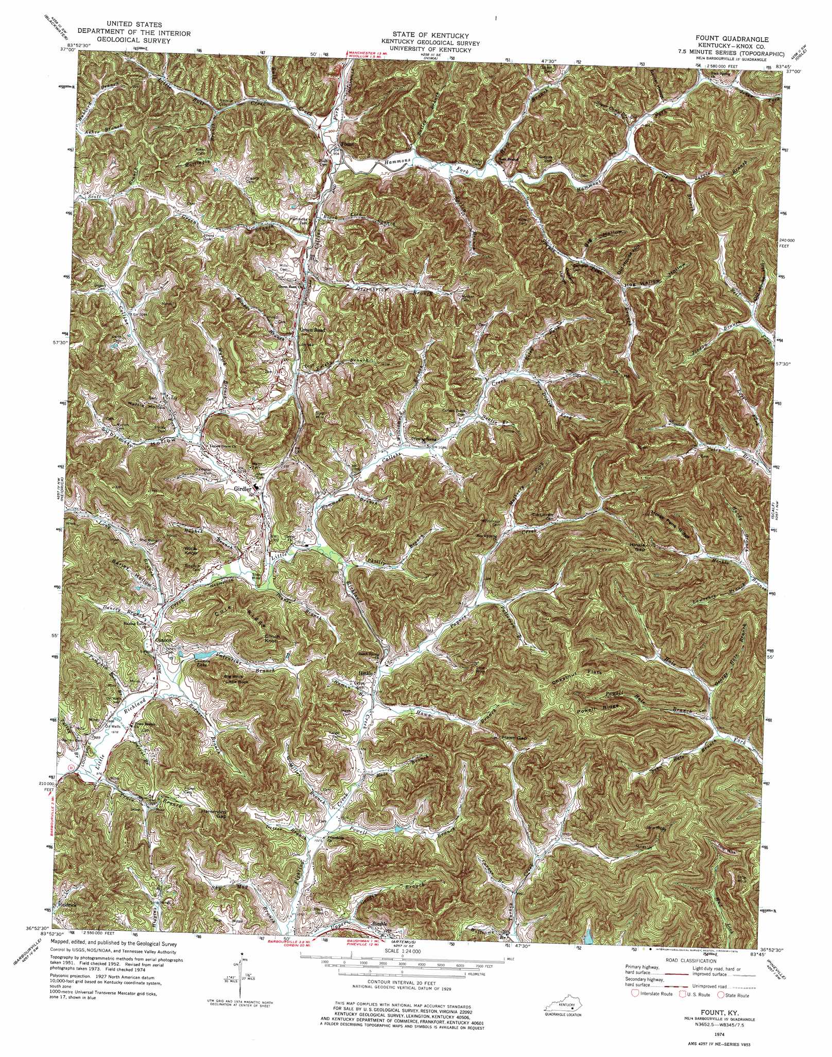
Fount Topo Map Kentucky
To zoom in, hover over the map of Fount
USGS Topo Quad 36083h7 - 1:24,000 scale
| Topo Map Name: | Fount |
| USGS Topo Quad ID: | 36083h7 |
| Print Size: | ca. 21 1/4" wide x 27" high |
| Southeast Coordinates: | 36.875° N latitude / 83.75° W longitude |
| Map Center Coordinates: | 36.9375° N latitude / 83.8125° W longitude |
| U.S. State: | KY |
| Filename: | o36083h7.jpg |
| Download Map JPG Image: | Fount topo map 1:24,000 scale |
| Map Type: | Topographic |
| Topo Series: | 7.5´ |
| Map Scale: | 1:24,000 |
| Source of Map Images: | United States Geological Survey (USGS) |
| Alternate Map Versions: |
Fount KY 1952, updated 1953 Download PDF Buy paper map Fount KY 1974, updated 1975 Download PDF Buy paper map Fount KY 2010 Download PDF Buy paper map Fount KY 2013 Download PDF Buy paper map Fount KY 2016 Download PDF Buy paper map |
1:24,000 Topo Quads surrounding Fount
London |
Portersburg |
Manchester |
Barcreek |
Big Creek |
Lily |
Blackwater |
Hima |
Ogle |
Creekville |
Corbin |
Heidrick |
Fount |
Scalf |
Beverly |
Rockholds |
Barbourville |
Artemus |
Pineville |
Balkan |
Saxton |
Frakes |
Kayjay |
Middlesboro North |
Varilla |
> Back to 36083e1 at 1:100,000 scale
> Back to 36082a1 at 1:250,000 scale
> Back to U.S. Topo Maps home
Fount topo map: Gazetteer
Fount: Gaps
Hammons Gap elevation 417m 1368′Hawn Gap elevation 358m 1174′
Hinkle Gap elevation 394m 1292′
Fount: Populated Places
Bimble elevation 314m 1030′Cannon elevation 299m 980′
Girdler elevation 318m 1043′
Hinkle elevation 308m 1010′
Lower Cumberland elevation 291m 954′
Fount: Post Offices
Abel Post Office (historical) elevation 285m 935′Cannon Post Office (historical) elevation 301m 987′
Fount Post Office (historical) elevation 273m 895′
Girdler Post Office (historical) elevation 314m 1030′
Green Road Post Office (historical) elevation 279m 915′
Hinkle Post Office (historical) elevation 309m 1013′
Trace Branch Post Office (historical) elevation 302m 990′
Fount: Reservoirs
Cannon Lake elevation 306m 1003′Fount: Ridges
Chestnut Flats elevation 504m 1653′Cole Ridge elevation 433m 1420′
Horse Pens Ridge elevation 508m 1666′
Powell Ridge elevation 496m 1627′
Fount: Streams
Asher Branch elevation 314m 1030′Bailey Branch elevation 275m 902′
Black Lick Branch elevation 274m 898′
Bull Creek elevation 274m 898′
Bunker Branch elevation 284m 931′
Burton Branch elevation 276m 905′
Callebs Creek elevation 301m 987′
Carnes Branch elevation 306m 1003′
Dancey Branch elevation 299m 980′
Dozier Branch elevation 313m 1026′
Frisby Branch elevation 283m 928′
George Hale Branch elevation 312m 1023′
Green Branch elevation 274m 898′
Greenbriar Branch elevation 278m 912′
Hale Branch elevation 322m 1056′
Hammans Branch elevation 304m 997′
Hammons Fork elevation 274m 898′
Hardy Branch elevation 310m 1017′
Hawn Branch elevation 310m 1017′
Horn Branch elevation 277m 908′
Hughes Branch elevation 301m 987′
Jarvis Branch elevation 300m 984′
John Hale Branch elevation 308m 1010′
Jones Fork elevation 291m 954′
Jordan Branch elevation 312m 1023′
Lawrence Branch elevation 308m 1010′
Little Bull Creek elevation 275m 902′
Long Branch elevation 301m 987′
Lost Fork elevation 310m 1017′
Mattingly Branch elevation 286m 938′
Miller Branch elevation 314m 1030′
Mulberry Fork elevation 319m 1046′
Nealie Branch elevation 311m 1020′
Numan Branch elevation 309m 1013′
Parrot Branch elevation 295m 967′
Patterson Branch elevation 311m 1020′
Payne Creek elevation 307m 1007′
Paynes Branch elevation 304m 997′
Phillip Branch elevation 301m 987′
Powell Branch elevation 313m 1026′
Powell Hale Branch elevation 309m 1013′
Pumpkin Run Branch elevation 295m 967′
Ridner Branch elevation 298m 977′
Riley Fork elevation 313m 1026′
Shop Branch elevation 283m 928′
Smith Branch elevation 306m 1003′
Spruce Pine Branch elevation 278m 912′
Sugar Camp Branch elevation 284m 931′
Tom Doolin Fork elevation 318m 1043′
Trace Branch elevation 299m 980′
Tulley Branch elevation 297m 974′
Turkey Creek elevation 303m 994′
Valentine Branch elevation 297m 974′
Williams Branch elevation 303m 994′
Williamson Branch elevation 307m 1007′
Wyrick Branch elevation 293m 961′
Fount: Summits
Beech Hill elevation 456m 1496′Big Rock elevation 421m 1381′
Clinch Knob elevation 461m 1512′
Little Rock elevation 426m 1397′
The Corral elevation 476m 1561′
Willis Knob elevation 455m 1492′
Fount: Valleys
Barley Hollow elevation 305m 1000′Big Hollow elevation 299m 980′
Garden Hollow elevation 296m 971′
Hog Wallow Hollow elevation 304m 997′
Martin Hollow elevation 304m 997′
Old House Hollow elevation 316m 1036′
Old House Hollow elevation 305m 1000′
Orchard Hollow elevation 297m 974′
Sublimity Hollow elevation 302m 990′
Fount digital topo map on disk
Buy this Fount topo map showing relief, roads, GPS coordinates and other geographical features, as a high-resolution digital map file on DVD:
Western Virginia & Southern West Virginia
Buy digital topo maps: Western Virginia & Southern West Virginia