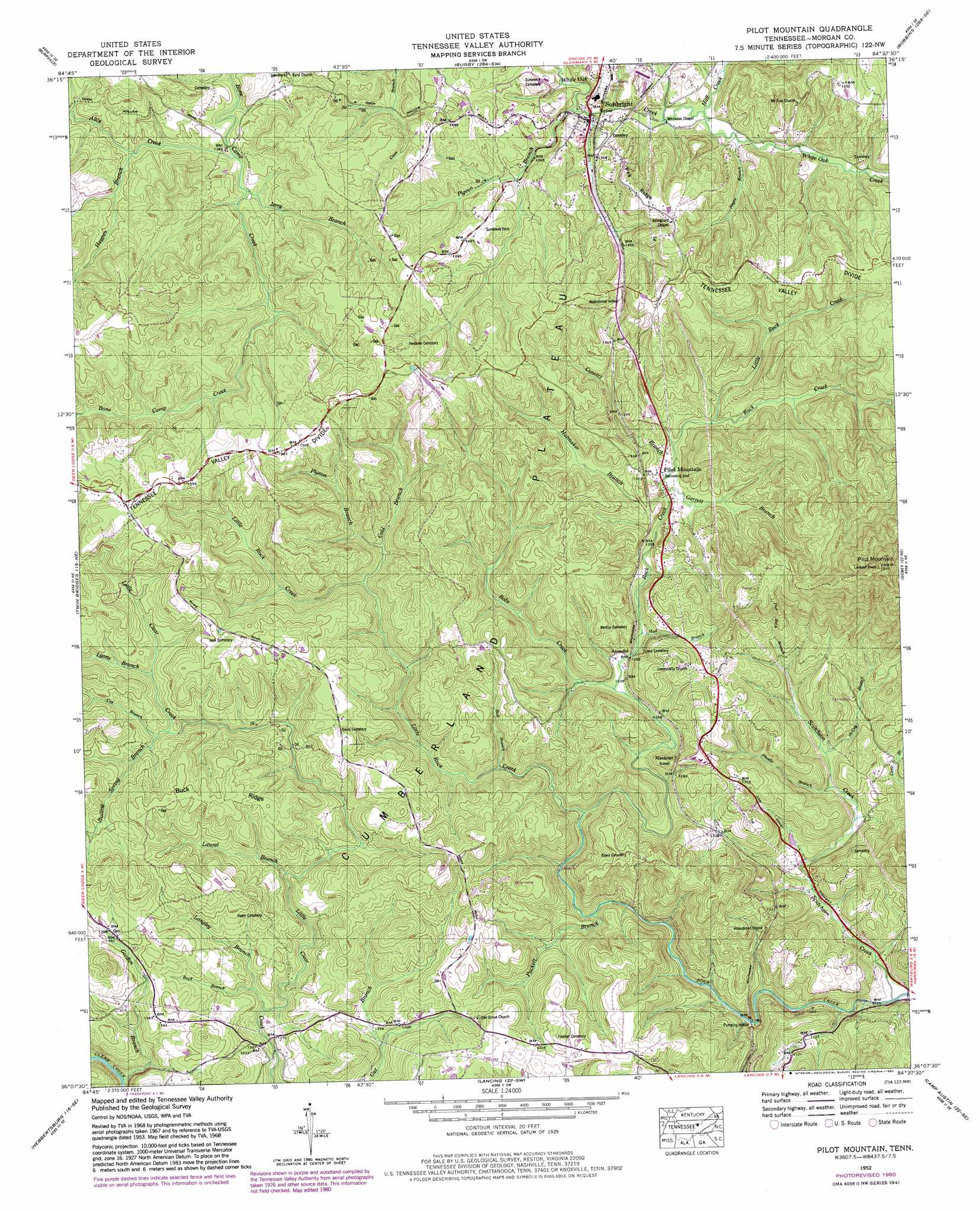
Pilot Mountain Topo Map Tennessee
To zoom in, hover over the map of Pilot Mountain
USGS Topo Quad 36084b6 - 1:24,000 scale
| Topo Map Name: | Pilot Mountain |
| USGS Topo Quad ID: | 36084b6 |
| Print Size: | ca. 21 1/4" wide x 27" high |
| Southeast Coordinates: | 36.125° N latitude / 84.625° W longitude |
| Map Center Coordinates: | 36.1875° N latitude / 84.6875° W longitude |
| U.S. State: | TN |
| Filename: | o36084b6.jpg |
| Download Map JPG Image: | Pilot Mountain topo map 1:24,000 scale |
| Map Type: | Topographic |
| Topo Series: | 7.5´ |
| Map Scale: | 1:24,000 |
| Source of Map Images: | United States Geological Survey (USGS) |
| Alternate Map Versions: |
Pilot Mountain TN 1935 Download PDF Buy paper map Pilot Mountain TN 1946, updated 1947 Download PDF Buy paper map Pilot Mountain TN 1952, updated 1954 Download PDF Buy paper map Pilot Mountain TN 1952, updated 1973 Download PDF Buy paper map Pilot Mountain TN 1952, updated 1980 Download PDF Buy paper map Pilot Mountain TN 2010 Download PDF Buy paper map Pilot Mountain TN 2013 Download PDF Buy paper map Pilot Mountain TN 2016 Download PDF Buy paper map |
1:24,000 Topo Quads surrounding Pilot Mountain
Jamestown |
Stockton |
Honey Creek |
Oneida South |
Huntsville |
Grimsley |
Burrville |
Rugby |
Robbins |
Norma |
Jones Knob |
Twin Bridges |
Pilot Mountain |
Gobey |
Fork Mountain |
Fox Creek |
Hebbertsburg |
Lancing |
Camp Austin |
Petros |
Dorton |
Ozone |
Cardiff |
Harriman |
Elverton |
> Back to 36084a1 at 1:100,000 scale
> Back to 36084a1 at 1:250,000 scale
> Back to U.S. Topo Maps home
Pilot Mountain topo map: Gazetteer
Pilot Mountain: Oilfields
Coon Hollow Oil Field elevation 426m 1397′Douglas Branch East Oil Field elevation 428m 1404′
Little Clear Creek Oil Field elevation 407m 1335′
Pilot Mountain Oil Field elevation 414m 1358′
Sunbright Oil Field elevation 457m 1499′
Pilot Mountain: Parks
Summers Park elevation 450m 1476′Pilot Mountain: Populated Places
Annadel elevation 374m 1227′Islandford (historical) elevation 390m 1279′
Pilot Mountain elevation 384m 1259′
Sunbright elevation 400m 1312′
Pilot Mountain: Post Offices
Sunbright Post Office elevation 405m 1328′Pilot Mountain: Ridges
Buck Ridge elevation 463m 1519′Pea Ridge elevation 478m 1568′
Pilot Mountain: Streams
Alice Creek elevation 413m 1354′Bobs Creek elevation 367m 1204′
Boiling Spring Branch elevation 400m 1312′
Buck Branch elevation 377m 1236′
Bull Branch elevation 365m 1197′
Cold Branch elevation 394m 1292′
Convict Branch elevation 385m 1263′
Cox Branch elevation 404m 1325′
Flat Rock Branch elevation 365m 1197′
Garrett Branch elevation 384m 1259′
Gordon Branch elevation 339m 1112′
Hall Branch elevation 401m 1315′
Hatmaker Branch elevation 383m 1256′
Haypen Branch elevation 417m 1368′
Jerry Branch elevation 414m 1358′
Langley Branch elevation 371m 1217′
Laurel Branch elevation 389m 1276′
Little Rock Creek elevation 386m 1266′
Little Rock Creek elevation 359m 1177′
Lyons Branch elevation 401m 1315′
McCoy Branch elevation 338m 1108′
Mud Branch elevation 371m 1217′
Negro Branch elevation 399m 1309′
Phoebe Branch elevation 333m 1092′
Pigeon Branch elevation 401m 1315′
Pigeon Branch elevation 394m 1292′
Puckett Branch elevation 339m 1112′
Scutcheon Creek elevation 311m 1020′
Pilot Mountain: Summits
Pilot Mountain elevation 764m 2506′Pilot Mountain: Valleys
Happy Hollow elevation 326m 1069′Pilot Mountain digital topo map on disk
Buy this Pilot Mountain topo map showing relief, roads, GPS coordinates and other geographical features, as a high-resolution digital map file on DVD: