White Pockets Topo Map Arizona
To zoom in, hover over the map of White Pockets
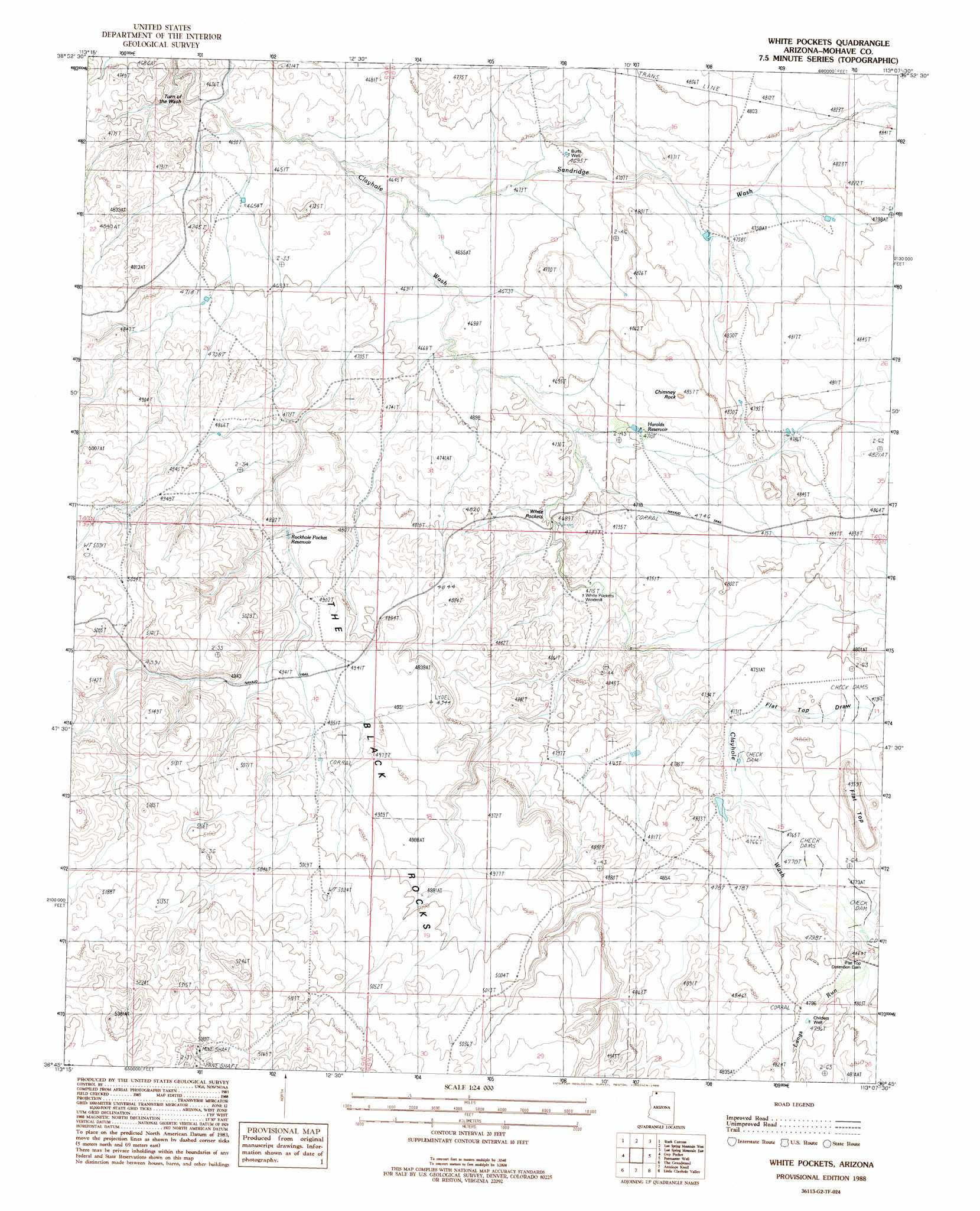
USGS Topo Quad 36113g2 - 1:24,000 scale
| Topo Map Name: | White Pockets |
| USGS Topo Quad ID: | 36113g2 |
| Print Size: | ca. 21 1/4" wide x 27" high |
| Southeast Coordinates: | 36.75° N latitude / 113.125° W longitude |
| Map Center Coordinates: | 36.8125° N latitude / 113.1875° W longitude |
| U.S. State: | AZ |
| Filename: | o36113g2.jpg |
| Download Map JPG Image: | White Pockets topo map 1:24,000 scale |
| Map Type: | Topographic |
| Topo Series: | 7.5´ |
| Map Scale: | 1:24,000 |
| Source of Map Images: | United States Geological Survey (USGS) |
| Alternate Map Versions: |
White Pockets AZ 1988, updated 1988 Download PDF Buy paper map White Pockets AZ 2011 Download PDF Buy paper map White Pockets AZ 2014 Download PDF Buy paper map |
1:24,000 Topo Quads surrounding White Pockets
Washington Dome |
The Divide |
Little Creek Mountain |
Smithsonian Butte |
Hildale |
Yellowhorse Flat |
Rock Canyon |
Lost Spring Mountain West |
Lost Spring Mountain East |
Colorado City |
Hole-N-Wall Canyon |
Gyp Pocket |
White Pockets |
Formaster Well |
Maroney Well |
Dutchman Draw |
The Grandstand |
Antelope Knoll |
Little Clayhole Valley |
Wild Band Pockets |
Little Tanks |
Russell Spring |
Moriah Knoll |
Hat Knoll |
Heaton Knolls |
> Back to 36113e1 at 1:100,000 scale
> Back to 36112a1 at 1:250,000 scale
> Back to U.S. Topo Maps home
White Pockets topo map: Gazetteer
White Pockets: Areas
The Black Rocks elevation 1514m 4967′White Pockets: Basins
White Pocket elevation 1433m 4701′White Pockets: Bends
Turn off the Wash elevation 1403m 4603′White Pockets: Dams
Flat Top Detention Dam elevation 1463m 4799′White Pockets Water Catchment elevation 1535m 5036′
White Pockets: Pillars
Chimney Rock elevation 1466m 4809′White Pockets: Reservoirs
Harolds Reservoir elevation 1434m 4704′Rockhole Pocket Reservoir elevation 1474m 4835′
Snake Pond elevation 1458m 4783′
White Pockets: Streams
Langs Run elevation 1463m 4799′Sandridge Wash elevation 0m 0′
White Pockets: Summits
Flat Top elevation 1508m 4947′White Pockets: Trails
Navajo Trail elevation 1509m 4950′White Pockets: Valleys
Flattop Draw elevation 1446m 4744′White Pockets: Wells
Burts Well elevation 1432m 4698′Childers Well elevation 1463m 4799′
White Pockets digital topo map on disk
Buy this White Pockets topo map showing relief, roads, GPS coordinates and other geographical features, as a high-resolution digital map file on DVD: