Seven Pines Topo Map Virginia
To zoom in, hover over the map of Seven Pines
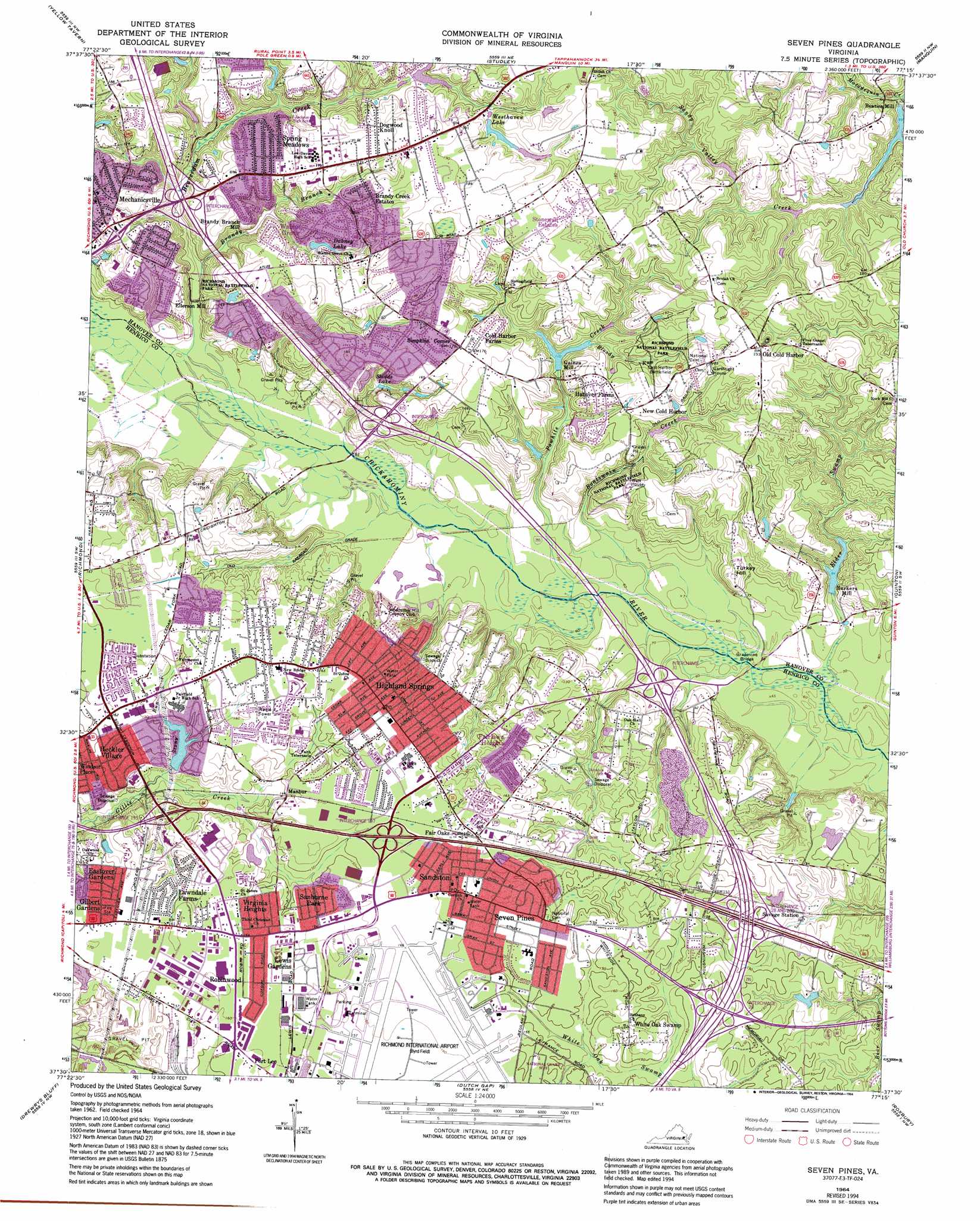
USGS Topo Quad 37077e3 - 1:24,000 scale
| Topo Map Name: | Seven Pines |
| USGS Topo Quad ID: | 37077e3 |
| Print Size: | ca. 21 1/4" wide x 27" high |
| Southeast Coordinates: | 37.5° N latitude / 77.25° W longitude |
| Map Center Coordinates: | 37.5625° N latitude / 77.3125° W longitude |
| U.S. State: | VA |
| Filename: | o37077e3.jpg |
| Download Map JPG Image: | Seven Pines topo map 1:24,000 scale |
| Map Type: | Topographic |
| Topo Series: | 7.5´ |
| Map Scale: | 1:24,000 |
| Source of Map Images: | United States Geological Survey (USGS) |
| Alternate Map Versions: |
Seven Pines VA 1934 Download PDF Buy paper map Seven Pines VA 1956, updated 1959 Download PDF Buy paper map Seven Pines VA 1964, updated 1966 Download PDF Buy paper map Seven Pines VA 1964, updated 1969 Download PDF Buy paper map Seven Pines VA 1964, updated 1976 Download PDF Buy paper map Seven Pines VA 1964, updated 1982 Download PDF Buy paper map Seven Pines VA 1964, updated 1987 Download PDF Buy paper map Seven Pines VA 1964, updated 1994 Download PDF Buy paper map Seven Pines VA 2010 Download PDF Buy paper map Seven Pines VA 2013 Download PDF Buy paper map Seven Pines VA 2016 Download PDF Buy paper map |
1:24,000 Topo Quads surrounding Seven Pines
Hanover Academy |
Ashland |
Hanover |
Beulahville |
Aylett |
Glen Allen |
Yellow Tavern |
Studley |
Manquin |
King William |
Bon Air |
Richmond |
Seven Pines |
Quinton |
Tunstall |
Chesterfield |
Drewrys Bluff |
Dutch Gap |
Roxbury |
Providence Forge |
Beach |
Chester |
Hopewell |
Westover |
Charles City |
> Back to 37077e1 at 1:100,000 scale
> Back to 37076a1 at 1:250,000 scale
> Back to U.S. Topo Maps home
Seven Pines topo map: Gazetteer
Seven Pines: Airports
Christians Airport elevation 56m 183′Richmond International Airport elevation 48m 157′
Seven Pines: Bridges
Grapevine Bridge elevation 18m 59′Seven Pines: Crossings
Interchange 195 elevation 43m 141′Interchange 197 elevation 54m 177′
Interchange 200 elevation 45m 147′
Interchange 28 elevation 45m 147′
Interchange 31 elevation 25m 82′
Interchange 34 elevation 35m 114′
Interchange 37 elevation 32m 104′
Seven Pines: Dams
Barkers Millpond Dam elevation 27m 88′Cherrydale Dam elevation 39m 127′
Gaines Mill Dam elevation 44m 144′
Gillies Creek Dam elevation 41m 134′
Westhaven Lake Dam elevation 45m 147′
Seven Pines: Parks
Matthew James Robinson Park elevation 51m 167′Seven Pines: Populated Places
Barkers Mill elevation 34m 111′Beaties Mill elevation 33m 108′
Brandy Creek Estates elevation 45m 147′
Cold Harbor Farms elevation 52m 170′
Dogwood Knoll elevation 56m 183′
Eastover Gardens elevation 45m 147′
Ellerson Mill elevation 29m 95′
Fair Oaks elevation 51m 167′
Fairlawn Heights elevation 49m 160′
Forest Meadow Mobile Home Park elevation 44m 144′
Gaines Mill elevation 33m 108′
Gilbert Gardens elevation 48m 157′
Hanover Farms elevation 43m 141′
Heckler Village elevation 39m 127′
Highland Springs elevation 52m 170′
Kirbytown elevation 51m 167′
Lawndale Farms elevation 48m 157′
Lee Park elevation 48m 157′
Lewis Gardens elevation 48m 157′
Manbur elevation 46m 150′
Mechanicsville elevation 51m 167′
New Cold Harbor elevation 49m 160′
Old Cold Harbor elevation 58m 190′
Pine Heights elevation 49m 160′
Robinwood elevation 51m 167′
Sanburne Park elevation 45m 147′
Sandston elevation 51m 167′
Sandston Highland elevation 47m 154′
Seven Pines elevation 49m 160′
Simpkins Corner elevation 53m 173′
Spring Meadows elevation 50m 164′
Stonewall Estates elevation 58m 190′
Valley Oaks elevation 54m 177′
Virginia Heights elevation 49m 160′
Walnut Grove elevation 49m 160′
White Oak Swamp elevation 46m 150′
Windsor Place elevation 46m 150′
Woodlawn Terrace elevation 47m 154′
Seven Pines: Post Offices
Dominion Village Post Office elevation 49m 160′Highland Springs Post Office elevation 52m 170′
Mechanicsville Post Office elevation 55m 180′
Montrose Heights Post Office elevation 50m 164′
Sandston Post Office elevation 51m 167′
Seven Pines: Reservoirs
Barkers Millpond elevation 27m 88′Cherrydale Pond elevation 39m 127′
Dabney Lake elevation 39m 127′
Eberhard Pond elevation 23m 75′
Gaines Millpond elevation 44m 144′
Sledds Lake elevation 34m 111′
Westhaven Lake elevation 45m 147′
Westhaven Lake elevation 50m 164′
Seven Pines: Streams
Beaverdam Creek elevation 23m 75′Bloody Run elevation 34m 111′
Boatswain Creek elevation 18m 59′
Brandy Branch elevation 25m 82′
Elder Swamp elevation 18m 59′
Powhite Creek elevation 18m 59′
Sandy Valley Creek elevation 26m 85′
Stony Run elevation 31m 101′
Tuckers Branch elevation 18m 59′
Seven Pines: Summits
Turkey Hill elevation 43m 141′Seven Pines digital topo map on disk
Buy this Seven Pines topo map showing relief, roads, GPS coordinates and other geographical features, as a high-resolution digital map file on DVD:
Atlantic Coast (NY, NJ, PA, DE, MD, VA, NC)
Buy digital topo maps: Atlantic Coast (NY, NJ, PA, DE, MD, VA, NC)
 map DVD")