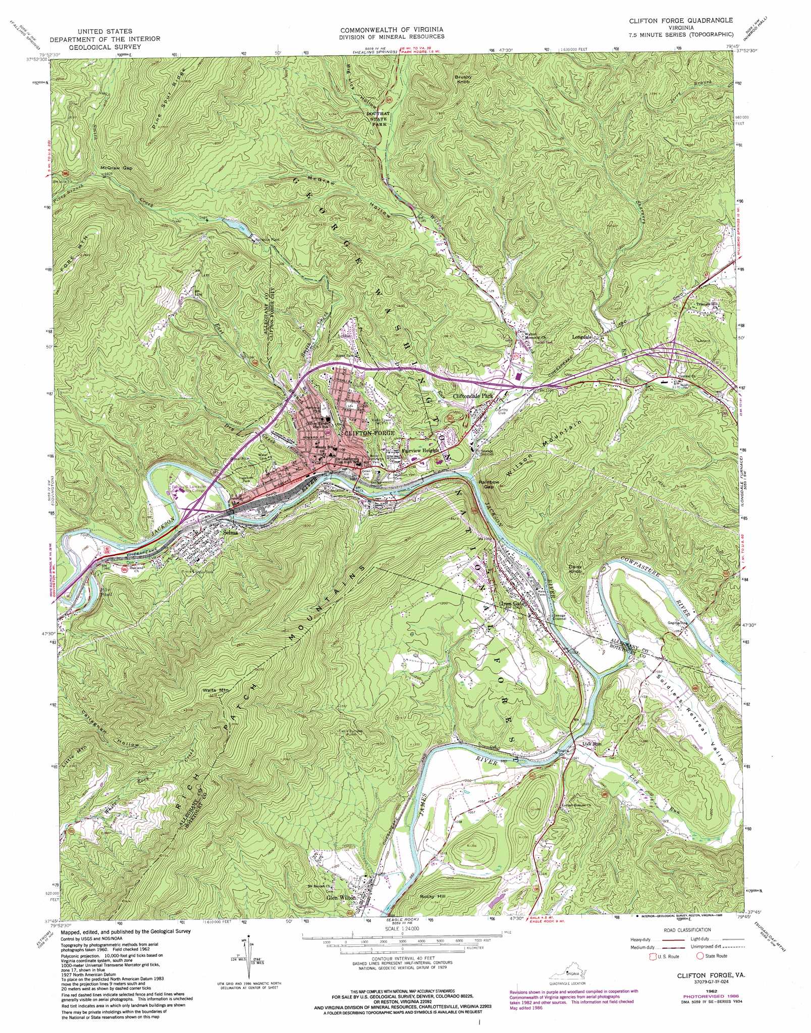
Clifton Forge Topo Map Virginia
To zoom in, hover over the map of Clifton Forge
USGS Topo Quad 37079g7 - 1:24,000 scale
| Topo Map Name: | Clifton Forge |
| USGS Topo Quad ID: | 37079g7 |
| Print Size: | ca. 21 1/4" wide x 27" high |
| Southeast Coordinates: | 37.75° N latitude / 79.75° W longitude |
| Map Center Coordinates: | 37.8125° N latitude / 79.8125° W longitude |
| U.S. State: | VA |
| Filename: | o37079g7.jpg |
| Download Map JPG Image: | Clifton Forge topo map 1:24,000 scale |
| Map Type: | Topographic |
| Topo Series: | 7.5´ |
| Map Scale: | 1:24,000 |
| Source of Map Images: | United States Geological Survey (USGS) |
| Alternate Map Versions: |
Clifton Forge VA 1962, updated 1964 Download PDF Buy paper map Clifton Forge VA 1962, updated 1971 Download PDF Buy paper map Clifton Forge VA 1962, updated 1979 Download PDF Buy paper map Clifton Forge VA 1962, updated 1986 Download PDF Buy paper map Clifton Forge VA 1962, updated 1986 Download PDF Buy paper map Clifton Forge VA 2011 Download PDF Buy paper map Clifton Forge VA 2013 Download PDF Buy paper map Clifton Forge VA 2016 Download PDF Buy paper map |
| FStopo: | US Forest Service topo Clifton Forge is available: Download FStopo PDF Download FStopo TIF |
1:24,000 Topo Quads surrounding Clifton Forge
Lake Sherwood |
Mountain Grove |
Warm Springs |
Bath Alum |
Green Valley |
Rucker Gap |
Falling Spring |
Healing Springs |
Nimrod Hall |
Millboro |
Callaghan |
Covington |
Clifton Forge |
Longdale Furnace |
Collierstown |
Jordan Mines |
Strom |
Eagle Rock |
Sugarloaf Mountain |
Natural Bridge |
New Castle |
Oriskany |
Salisbury |
Buchanan |
Arnold Valley |
> Back to 37079e1 at 1:100,000 scale
> Back to 37078a1 at 1:250,000 scale
> Back to U.S. Topo Maps home
Clifton Forge topo map: Gazetteer
Clifton Forge: Airports
Riverwood Airport elevation 322m 1056′Clifton Forge: Bridges
Robert F Craft Memorial Bridge elevation 316m 1036′Clifton Forge: Crossings
Interchange 24 elevation 340m 1115′Interchange 27 elevation 338m 1108′
Interchange 29 elevation 380m 1246′
Clifton Forge: Dams
Clifton Forge Lower Dam elevation 453m 1486′Clifton Forge: Gaps
McGraw Gap elevation 494m 1620′Rainbow Gap elevation 310m 1017′
Clifton Forge: Lakes
Pike Pond elevation 337m 1105′Clifton Forge: Parks
Booker T Washington Park elevation 336m 1102′Ingleside Park elevation 354m 1161′
Linden Park elevation 401m 1315′
Memorial Park elevation 341m 1118′
Clifton Forge: Populated Places
Clifton Forge elevation 330m 1082′Cliftondale Park elevation 326m 1069′
Fairview Heights elevation 380m 1246′
Glen Wilton elevation 305m 1000′
Iron Gate elevation 316m 1036′
Longdale elevation 363m 1190′
Selma elevation 350m 1148′
Clifton Forge: Post Offices
Clifton Forge Post Office elevation 328m 1076′Clifton Forge: Reservoirs
Clifton Forge Reservoir elevation 453m 1486′Clifton Forge: Ridges
Pine Spur Ridge elevation 862m 2828′Clifton Forge: Streams
Cowpasture River elevation 302m 990′Dry Creek elevation 335m 1099′
Dry Run elevation 316m 1036′
East Branch Jackson River elevation 319m 1046′
Jackson River elevation 302m 990′
Lick Run elevation 300m 984′
Piney Branch elevation 486m 1594′
Smith Creek elevation 317m 1040′
Wilson Creek elevation 311m 1020′
Clifton Forge: Summits
Brushy Knob elevation 661m 2168′Daisy Knob elevation 380m 1246′
Little Mountain elevation 710m 2329′
Rocky Hill elevation 466m 1528′
Waits Mountain elevation 977m 3205′
Wilson Mountain elevation 574m 1883′
Clifton Forge: Valleys
Big Lick Hollow elevation 389m 1276′McGraw Hollow elevation 363m 1190′
Rockbury Hollow elevation 325m 1066′
Soldiers Retreat Valley elevation 311m 1020′
Clifton Forge digital topo map on disk
Buy this Clifton Forge topo map showing relief, roads, GPS coordinates and other geographical features, as a high-resolution digital map file on DVD:
Western Virginia & Southern West Virginia
Buy digital topo maps: Western Virginia & Southern West Virginia