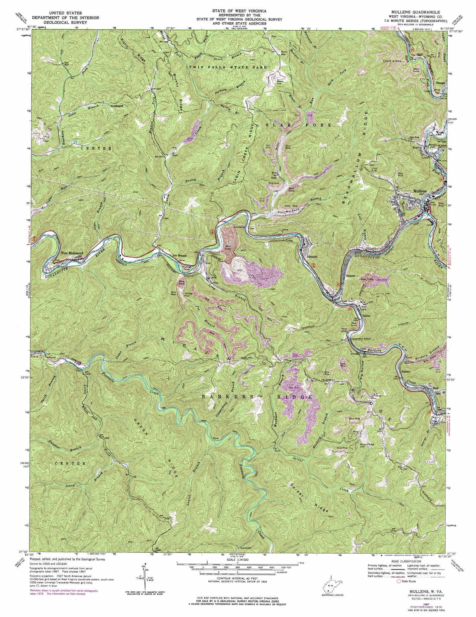
Mullens Topo Map West Virginia
To zoom in, hover over the map of Mullens
USGS Topo Quad 37081e4 - 1:24,000 scale
| Topo Map Name: | Mullens |
| USGS Topo Quad ID: | 37081e4 |
| Print Size: | ca. 21 1/4" wide x 27" high |
| Southeast Coordinates: | 37.5° N latitude / 81.375° W longitude |
| Map Center Coordinates: | 37.5625° N latitude / 81.4375° W longitude |
| U.S. State: | WV |
| Filename: | o37081e4.jpg |
| Download Map JPG Image: | Mullens topo map 1:24,000 scale |
| Map Type: | Topographic |
| Topo Series: | 7.5´ |
| Map Scale: | 1:24,000 |
| Source of Map Images: | United States Geological Survey (USGS) |
| Alternate Map Versions: |
Mullens WV 1967, updated 1971 Download PDF Buy paper map Mullens WV 1967, updated 1977 Download PDF Buy paper map Mullens WV 1996, updated 2003 Download PDF Buy paper map Mullens WV 2011 Download PDF Buy paper map Mullens WV 2014 Download PDF Buy paper map Mullens WV 2016 Download PDF Buy paper map |
1:24,000 Topo Quads surrounding Mullens
Lorado |
Pilot Knob |
Arnett |
Eccles |
Beckley |
Oceana |
Matheny |
Mcgraws |
Lester |
Crab Orchard |
Baileysville |
Pineville |
Mullens |
Rhodell |
Odd |
Davy |
Welch |
Keystone |
Crumpler |
Matoaka |
War |
Gary |
Anawalt |
Bramwell |
Bluefield |
> Back to 37081e1 at 1:100,000 scale
> Back to 37080a1 at 1:250,000 scale
> Back to U.S. Topo Maps home
Mullens topo map: Gazetteer
Mullens: Dams
Joes Branch Refuse Impoundment Dam elevation 516m 1692′Slab Fork-Otsego Dam elevation 592m 1942′
Wyco Number Two Refuse Embankment Dam elevation 522m 1712′
Mullens: Populated Places
Alpoca elevation 460m 1509′Bud elevation 470m 1541′
Elmore elevation 426m 1397′
Itmann elevation 423m 1387′
Joe Branch elevation 422m 1384′
Mullens elevation 432m 1417′
New Richmond elevation 416m 1364′
Newfound elevation 586m 1922′
Nuriva elevation 454m 1489′
Otsego elevation 469m 1538′
Tralee elevation 433m 1420′
Mullens: Post Offices
Alpoca Post Office elevation 462m 1515′Mullens: Reservoirs
Elmore Mine Impoundment elevation 522m 1712′Joes Branch Refuse Impoundment elevation 516m 1692′
Otsego Mine Impoundment elevation 592m 1942′
Mullens: Ridges
Brushy Ridge elevation 684m 2244′Cabin Creek Ridge elevation 683m 2240′
Green Ridge elevation 680m 2230′
Micajah Ridge elevation 684m 2244′
Spider Ridge elevation 706m 2316′
Mullens: Streams
Barkers Creek elevation 420m 1377′Bearpen Branch elevation 519m 1702′
Bill Branch elevation 424m 1391′
Black Fork elevation 550m 1804′
Bower Branch elevation 482m 1581′
Cabin Creek elevation 411m 1348′
Cedar Branch elevation 433m 1420′
Cedar Creek elevation 464m 1522′
Copperhead Branch elevation 468m 1535′
Dixon Branch elevation 593m 1945′
Farley Branch elevation 440m 1443′
George Branch elevation 473m 1551′
Goode Branch elevation 550m 1804′
Halsey Branch elevation 502m 1646′
Hickory Branch elevation 525m 1722′
Horsepen Branch elevation 532m 1745′
Jackson Branch elevation 507m 1663′
Jenny Branch elevation 513m 1683′
Jims Branch elevation 405m 1328′
Joe Branch elevation 516m 1692′
Laurel Branch elevation 470m 1541′
Little White Oak Creek elevation 433m 1420′
Long Branch elevation 412m 1351′
Lost Branch elevation 427m 1400′
Marsh Fork elevation 553m 1814′
Meadow Fork elevation 455m 1492′
Mill Branch elevation 468m 1535′
Slab Fork elevation 430m 1410′
Smith Branch elevation 418m 1371′
Spider Creek elevation 485m 1591′
Still Run elevation 414m 1358′
Sulphur Branch elevation 489m 1604′
Terry Branch elevation 445m 1459′
Workman Branch elevation 501m 1643′
Workman Branch elevation 428m 1404′
Zack Fork elevation 496m 1627′
Mullens: Valleys
Big Hollow elevation 458m 1502′Mullens digital topo map on disk
Buy this Mullens topo map showing relief, roads, GPS coordinates and other geographical features, as a high-resolution digital map file on DVD:
Western Virginia & Southern West Virginia
Buy digital topo maps: Western Virginia & Southern West Virginia