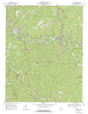
Pineville Topo Map West Virginia
To zoom in, hover over the map of Pineville
USGS Topo Quad 37081e5 - 1:24,000 scale
| Topo Map Name: | Pineville |
| USGS Topo Quad ID: | 37081e5 |
| Print Size: | ca. 21 1/4" wide x 27" high |
| Southeast Coordinates: | 37.5° N latitude / 81.5° W longitude |
| Map Center Coordinates: | 37.5625° N latitude / 81.5625° W longitude |
| U.S. State: | WV |
| Filename: | o37081e5.jpg |
| Download Map JPG Image: | Pineville topo map 1:24,000 scale |
| Map Type: | Topographic |
| Topo Series: | 7.5´ |
| Map Scale: | 1:24,000 |
| Source of Map Images: | United States Geological Survey (USGS) |
| Alternate Map Versions: |
Pineville WV 1967, updated 1971 Download PDF Buy paper map Pineville WV 1967, updated 1977 Download PDF Buy paper map Pineville WV 1996, updated 2003 Download PDF Buy paper map Pineville WV 2011 Download PDF Buy paper map Pineville WV 2014 Download PDF Buy paper map Pineville WV 2016 Download PDF Buy paper map |
1:24,000 Topo Quads surrounding Pineville
Amherstdale |
Lorado |
Pilot Knob |
Arnett |
Eccles |
Mallory |
Oceana |
Matheny |
Mcgraws |
Lester |
Gilbert |
Baileysville |
Pineville |
Mullens |
Rhodell |
Iaeger |
Davy |
Welch |
Keystone |
Crumpler |
Bradshaw |
War |
Gary |
Anawalt |
Bramwell |
> Back to 37081e1 at 1:100,000 scale
> Back to 37080a1 at 1:250,000 scale
> Back to U.S. Topo Maps home
Pineville topo map: Gazetteer
Pineville: Airports
Kee Field elevation 534m 1751′Swope Farm Airport elevation 530m 1738′
Pineville: Dams
Pinnacle Creek Refuse Bank Dam elevation 598m 1961′Refuse Dam and Impoundment Number One elevation 534m 1751′
Pineville: Populated Places
Glover elevation 372m 1220′Marianna elevation 364m 1194′
Mullensville elevation 388m 1272′
Pineville elevation 395m 1295′
Rock View elevation 483m 1584′
Windom elevation 515m 1689′
Woosley elevation 399m 1309′
Wyoming elevation 375m 1230′
Pineville: Post Offices
Wolf Pen Post Office elevation 390m 1279′Wyoming Post Office elevation 370m 1213′
Pineville: Reservoirs
Keppler Mine Impoundment elevation 534m 1751′Number 50 Earthfill Impoundment elevation 598m 1961′
Pineville: Ridges
Mill Ridge elevation 618m 2027′Turkey Ridge elevation 610m 2001′
Pineville: Streams
Bailey Branch elevation 408m 1338′Baldwin Branch elevation 398m 1305′
Bearhole Fork elevation 417m 1368′
Bee Branch elevation 386m 1266′
Belcher Branch elevation 411m 1348′
Big Branch elevation 364m 1194′
Bird Branch elevation 430m 1410′
Car Branch elevation 419m 1374′
Coon Fork elevation 519m 1702′
Gulf Branch elevation 437m 1433′
Hurricane Branch elevation 441m 1446′
Jacky Fork elevation 464m 1522′
Jud Branch elevation 380m 1246′
Lambert Branch elevation 403m 1322′
Left Fork Skin Fork elevation 430m 1410′
Lefthand Fork Bearhole Fork elevation 448m 1469′
Lick Branch elevation 388m 1272′
Marsh Fork elevation 475m 1558′
Mile Branch elevation 372m 1220′
Nancy Fork elevation 409m 1341′
Pinnacle Creek elevation 393m 1289′
Raccoon Branch elevation 386m 1266′
Rich Branch elevation 387m 1269′
Right Fork Turkey Creek elevation 408m 1338′
Righthand Fork Skin Fork elevation 514m 1686′
Rockcastle Creek elevation 391m 1282′
Shop Branch elevation 435m 1427′
Skin Fork elevation 363m 1190′
Spence Fork elevation 410m 1345′
Stanley Fork elevation 465m 1525′
Sugar Run elevation 398m 1305′
Swag Fork elevation 468m 1535′
Turkey Creek elevation 355m 1164′
Turkeywallow Branch elevation 394m 1292′
White Oak Branch elevation 482m 1581′
Williamson Branch elevation 384m 1259′
Wolf Pen Branch elevation 386m 1266′
Pineville digital topo map on disk
Buy this Pineville topo map showing relief, roads, GPS coordinates and other geographical features, as a high-resolution digital map file on DVD:
Western Virginia & Southern West Virginia
Buy digital topo maps: Western Virginia & Southern West Virginia


