Bee Spring Topo Map Kentucky
To zoom in, hover over the map of Bee Spring
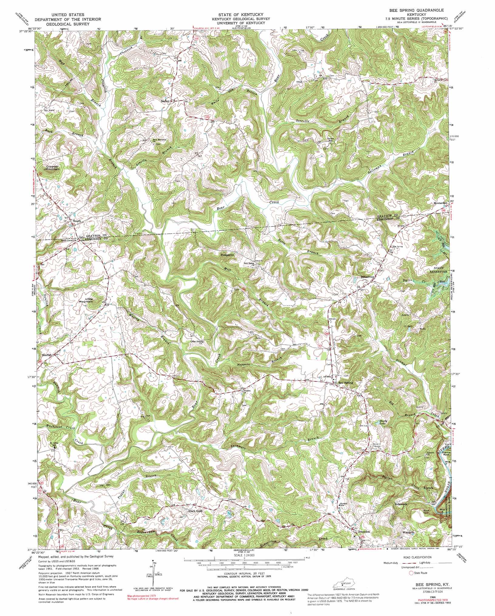
USGS Topo Quad 37086c3 - 1:24,000 scale
| Topo Map Name: | Bee Spring |
| USGS Topo Quad ID: | 37086c3 |
| Print Size: | ca. 21 1/4" wide x 27" high |
| Southeast Coordinates: | 37.25° N latitude / 86.25° W longitude |
| Map Center Coordinates: | 37.3125° N latitude / 86.3125° W longitude |
| U.S. State: | KY |
| Filename: | o37086c3.jpg |
| Download Map JPG Image: | Bee Spring topo map 1:24,000 scale |
| Map Type: | Topographic |
| Topo Series: | 7.5´ |
| Map Scale: | 1:24,000 |
| Source of Map Images: | United States Geological Survey (USGS) |
| Alternate Map Versions: |
Bee Spring KY 1953, updated 1955 Download PDF Buy paper map Bee Spring KY 1966, updated 1968 Download PDF Buy paper map Bee Spring KY 1966, updated 1991 Download PDF Buy paper map Bee Spring KY 2010 Download PDF Buy paper map Bee Spring KY 2013 Download PDF Buy paper map Bee Spring KY 2016 Download PDF Buy paper map |
1:24,000 Topo Quads surrounding Bee Spring
Falls Of Rough |
Mcdaniels |
Madrid |
Big Clifty |
Summit |
Spring Lick |
Caneyville |
Leitchfield |
Clarkson |
Millerstown |
Welchs Creek |
Ready |
Bee Spring |
Nolin Lake |
Cub Run |
Riverside |
Reedyville |
Brownsville |
Rhoda |
Mammoth Cave |
Hadley |
Bowling Green North |
Bristow |
Smiths Grove |
Park City |
> Back to 37086a1 at 1:100,000 scale
> Back to 37086a1 at 1:250,000 scale
> Back to U.S. Topo Maps home
Bee Spring topo map: Gazetteer
Bee Spring: Lakes
Shady Lake elevation 199m 652′Bee Spring: Populated Places
Bee Spring elevation 206m 675′Black Gold elevation 198m 649′
Broadway elevation 214m 702′
Kyrock elevation 161m 528′
Prosperity elevation 197m 646′
Ridgedale elevation 177m 580′
Sadler elevation 215m 705′
South elevation 187m 613′
Sunfish elevation 163m 534′
Sweeden elevation 232m 761′
Woodside elevation 233m 764′
Bee Spring: Streams
Beaverdam Creek elevation 128m 419′Big Branch elevation 143m 469′
Buck Branch elevation 138m 452′
Chenneth Branch elevation 152m 498′
Claylick Branch elevation 134m 439′
Coppers Branch elevation 130m 426′
Dismal Creek elevation 137m 449′
Lincoln Branch elevation 137m 449′
Mill Branch elevation 134m 439′
Mud Branch elevation 143m 469′
Nappers Branch elevation 132m 433′
Nells Branch elevation 137m 449′
Peggys Branch elevation 128m 419′
Pigeon Creek elevation 132m 433′
Salt Well Branch elevation 138m 452′
Saltsman Branch elevation 137m 449′
Sorrells Branch elevation 139m 456′
Sunfish Creek elevation 128m 419′
Sycamore Branch elevation 128m 419′
Watery Branch elevation 134m 439′
Whetstone Creek elevation 131m 429′
White Oak Branch elevation 140m 459′
Bee Spring: Summits
Crowder Mountain elevation 240m 787′Little Mountain elevation 231m 757′
Bee Spring digital topo map on disk
Buy this Bee Spring topo map showing relief, roads, GPS coordinates and other geographical features, as a high-resolution digital map file on DVD: