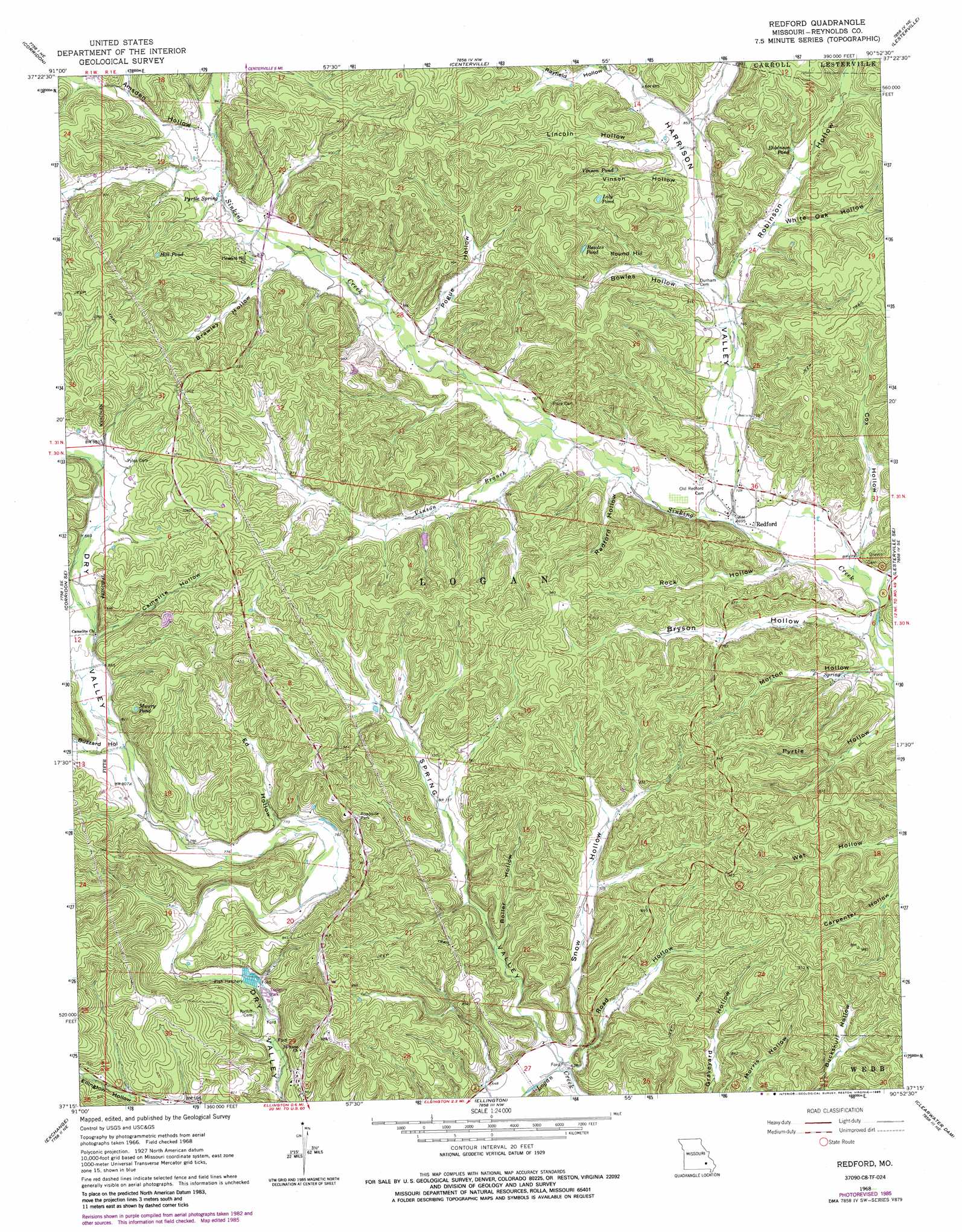
Redford Topo Map Missouri
To zoom in, hover over the map of Redford
USGS Topo Quad 37090c8 - 1:24,000 scale
| Topo Map Name: | Redford |
| USGS Topo Quad ID: | 37090c8 |
| Print Size: | ca. 21 1/4" wide x 27" high |
| Southeast Coordinates: | 37.25° N latitude / 90.875° W longitude |
| Map Center Coordinates: | 37.3125° N latitude / 90.9375° W longitude |
| U.S. State: | MO |
| Filename: | o37090c8.jpg |
| Download Map JPG Image: | Redford topo map 1:24,000 scale |
| Map Type: | Topographic |
| Topo Series: | 7.5´ |
| Map Scale: | 1:24,000 |
| Source of Map Images: | United States Geological Survey (USGS) |
| Alternate Map Versions: |
Redford MO 1968, updated 1970 Download PDF Buy paper map Redford MO 1968, updated 1985 Download PDF Buy paper map Redford MO 2011 Download PDF Buy paper map Redford MO 2015 Download PDF Buy paper map |
1:24,000 Topo Quads surrounding Redford
Greeley |
Oates |
Edgehill |
Johnson Shut-Ins |
Ironton |
Bunker |
Corridon |
Centerville |
Lesterville |
Glover |
Midridge |
Corridon Se |
Redford |
Lesterville Se |
Des Arc |
Powder Mill Ferry |
Exchange |
Ellington |
Clearwater Dam |
Piedmont |
Stegall Mountain |
Van Buren North |
Garwood |
Ellington Se |
Mill Spring |
> Back to 37090a1 at 1:100,000 scale
> Back to 37090a1 at 1:250,000 scale
> Back to U.S. Topo Maps home
Redford topo map: Gazetteer
Redford: Lakes
Bowles Pond elevation 291m 954′Lily Pond elevation 317m 1040′
Maury Pond elevation 282m 925′
Robinson Pond elevation 266m 872′
Vinson Pond elevation 294m 964′
Redford: Populated Places
Alamode (historical) elevation 266m 872′Redford elevation 213m 698′
Redford: Post Offices
Alamode Post Office (historical) elevation 266m 872′Redford: Reservoirs
Hill Pond elevation 311m 1020′Redford: Springs
Pyrtle Spring elevation 251m 823′Redford: Streams
Vinson Branch elevation 219m 718′Redford: Summits
Round Hill elevation 319m 1046′Redford: Valleys
Amsden Hollow elevation 260m 853′Ball Hollow elevation 194m 636′
Boiler Hollow elevation 209m 685′
Bowles Hollow elevation 240m 787′
Brawley Hollow elevation 251m 823′
Bryson Hollow elevation 203m 666′
Buzzard Hollow elevation 248m 813′
Camelite Hollow elevation 260m 853′
Cox Hollow elevation 207m 679′
Ed Hollow elevation 235m 770′
Harrison Valley elevation 215m 705′
Lincoln Hollow elevation 261m 856′
Morton Hollow elevation 199m 652′
Pogue Hollow elevation 238m 780′
Radford Hollow elevation 218m 715′
Rayfield Hollow elevation 274m 898′
Road Hollow elevation 185m 606′
Robinson Hollow elevation 240m 787′
Rock Hollow elevation 206m 675′
Snow Hollow elevation 192m 629′
Spring Valley elevation 192m 629′
Vinson Hollow elevation 253m 830′
White Oak Hollow elevation 253m 830′
Redford digital topo map on disk
Buy this Redford topo map showing relief, roads, GPS coordinates and other geographical features, as a high-resolution digital map file on DVD: