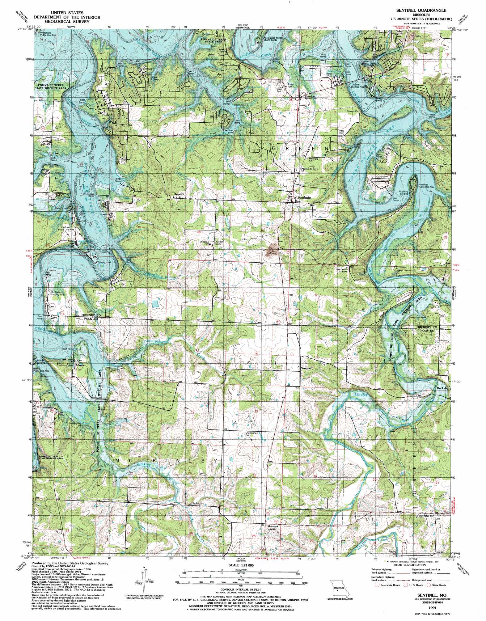
Sentinel Topo Map Missouri
To zoom in, hover over the map of Sentinel
USGS Topo Quad 37093g3 - 1:24,000 scale
| Topo Map Name: | Sentinel |
| USGS Topo Quad ID: | 37093g3 |
| Print Size: | ca. 21 1/4" wide x 27" high |
| Southeast Coordinates: | 37.75° N latitude / 93.25° W longitude |
| Map Center Coordinates: | 37.8125° N latitude / 93.3125° W longitude |
| U.S. State: | MO |
| Filename: | o37093g3.jpg |
| Download Map JPG Image: | Sentinel topo map 1:24,000 scale |
| Map Type: | Topographic |
| Topo Series: | 7.5´ |
| Map Scale: | 1:24,000 |
| Source of Map Images: | United States Geological Survey (USGS) |
| Alternate Map Versions: |
Sentinel MO 1949, updated 1973 Download PDF Buy paper map Sentinel MO 1949, updated 1982 Download PDF Buy paper map Sentinel MO 1950 Download PDF Buy paper map Sentinel MO 1980, updated 1982 Download PDF Buy paper map Sentinel MO 1991, updated 1991 Download PDF Buy paper map Sentinel MO 2011 Download PDF Buy paper map Sentinel MO 2015 Download PDF Buy paper map |
1:24,000 Topo Quads surrounding Sentinel
Iconium |
Quincy |
Fristoe |
Cross Timbers |
Climax Springs |
Weaubleau |
Wheatland |
Hermitage |
Preston |
Branch |
Humansville |
Elkton |
Sentinel |
Urbana |
Tunas |
Fair Play |
Cliquot |
Polk |
Buffalo Nw |
Buffalo |
Aldrich |
Bolivar |
Cedar Vista |
Half Way |
Charity |
> Back to 37093e1 at 1:100,000 scale
> Back to 37092a1 at 1:250,000 scale
> Back to U.S. Topo Maps home
Sentinel topo map: Gazetteer
Sentinel: Cliffs
Negro Bend Bluff elevation 256m 839′Sentinel: Parks
Lightfoot Public Use Area elevation 271m 889′Nemo Landing Public Use Area elevation 271m 889′
Pittsburg Landing Public Use Area elevation 273m 895′
Pittsburg Public Use Area elevation 256m 839′
Pomme de Terre State Wildlife Management Area elevation 265m 869′
Sentinel: Populated Places
Adonis elevation 263m 862′Mohawk Corner elevation 315m 1033′
Pittsburg elevation 318m 1043′
Sentinel elevation 311m 1020′
Sentinel: Streams
Big Hollow Branch elevation 256m 839′Claude Branch elevation 266m 872′
Decker Branch elevation 256m 839′
Ingalls Creek elevation 256m 839′
Little Decker Branch elevation 256m 839′
Mill Branch elevation 256m 839′
Possum Creek elevation 256m 839′
Stick Branch elevation 256m 839′
Stinking Creek elevation 256m 839′
Sentinel digital topo map on disk
Buy this Sentinel topo map showing relief, roads, GPS coordinates and other geographical features, as a high-resolution digital map file on DVD: