Pagosa Peak Topo Map Colorado
To zoom in, hover over the map of Pagosa Peak
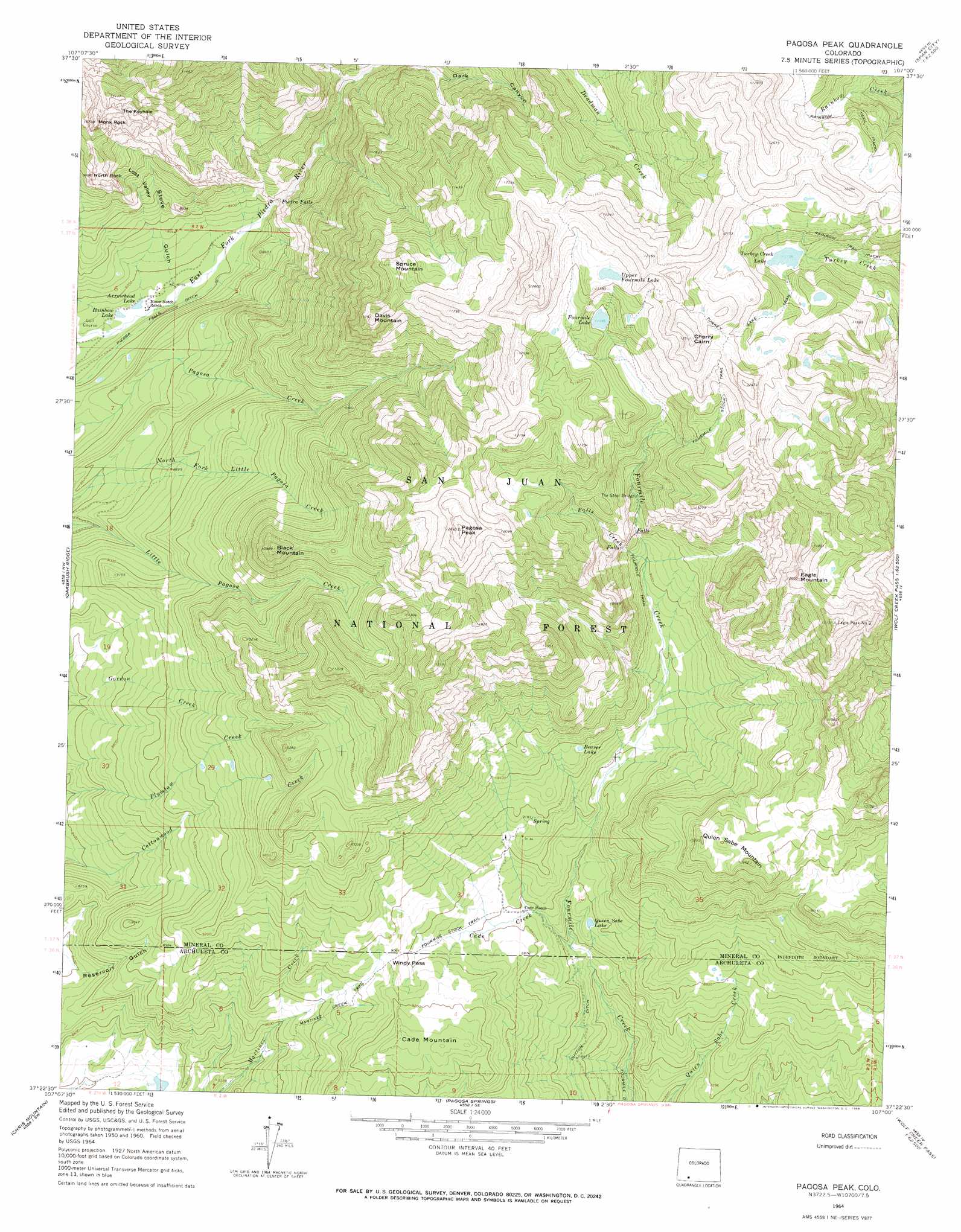
USGS Topo Quad 37107d1 - 1:24,000 scale
| Topo Map Name: | Pagosa Peak |
| USGS Topo Quad ID: | 37107d1 |
| Print Size: | ca. 21 1/4" wide x 27" high |
| Southeast Coordinates: | 37.375° N latitude / 107° W longitude |
| Map Center Coordinates: | 37.4375° N latitude / 107.0625° W longitude |
| U.S. State: | CO |
| Filename: | o37107d1.jpg |
| Download Map JPG Image: | Pagosa Peak topo map 1:24,000 scale |
| Map Type: | Topographic |
| Topo Series: | 7.5´ |
| Map Scale: | 1:24,000 |
| Source of Map Images: | United States Geological Survey (USGS) |
| Alternate Map Versions: |
Pagosa Peak CO 2011 Download PDF Buy paper map Pagosa Peak CO 2013 Download PDF Buy paper map Pagosa Peak CO 2016 Download PDF Buy paper map |
| FStopo: | US Forest Service topo Pagosa Peak is available: Download FStopo PDF Download FStopo TIF |
1:24,000 Topo Quads surrounding Pagosa Peak
Weminuche Pass |
Little Squaw Creek |
Workman Creek |
Spar City |
Lake Humphreys |
Granite Lake |
Cimarrona Peak |
Palomino Mountain |
South River Creek |
Mount Hope |
Bear Mountain |
Oakbrush Ridge |
Pagosa Peak |
Saddle Mountain |
Wolf Creek Pass |
Devil Mountain |
Chris Mountain |
Pagosa Springs |
Jackson Mountain |
Blackhead Peak |
Chimney Rock |
Lonetree Canyon |
Oakbrush Hill |
Serviceberry Mountain |
Harris Lake |
> Back to 37107a1 at 1:100,000 scale
> Back to 37106a1 at 1:250,000 scale
> Back to U.S. Topo Maps home
Pagosa Peak topo map: Gazetteer
Pagosa Peak: Bridges
The Steel Bridge elevation 3166m 10387′Pagosa Peak: Falls
Piedra Falls elevation 2566m 8418′Pagosa Peak: Gaps
Windy Pass elevation 2773m 9097′Pagosa Peak: Lakes
Arrowhead Lake elevation 2471m 8106′Beaver Lake elevation 2838m 9311′
Fourmile Lake elevation 3411m 11190′
Quien Sabe Lake elevation 2664m 8740′
Rainbow Lake elevation 2470m 8103′
Turkey Creek Lake elevation 3396m 11141′
Upper Fourmile Lake elevation 3555m 11663′
Pagosa Peak: Mines
Jim Tree Mine elevation 2825m 9268′Pagosa Peak: Pillars
Monk Rock elevation 3250m 10662′North Rock elevation 2949m 9675′
Pagosa Peak: Streams
Cade Creek elevation 2600m 8530′Falls Creek elevation 2865m 9399′
Pagosa Peak: Summits
Black Mountain elevation 3317m 10882′Cade Mountain elevation 2856m 9370′
Cherry Cairn elevation 3809m 12496′
Davis Mountain elevation 3591m 11781′
Eagle Mountain elevation 3586m 11765′
Pagosa Peak elevation 3827m 12555′
Quien Sabe Mountain elevation 3126m 10255′
Spruce Mountain elevation 3529m 11578′
The Keyhole elevation 3231m 10600′
Pagosa Peak: Trails
Fourmile Stock Trail elevation 2754m 9035′Martinez Creek Trail elevation 2662m 8733′
Turkey Lake Trail elevation 3474m 11397′
Pagosa Peak: Valleys
Lost Valley elevation 2558m 8392′Stove Gulch elevation 2481m 8139′
Pagosa Peak digital topo map on disk
Buy this Pagosa Peak topo map showing relief, roads, GPS coordinates and other geographical features, as a high-resolution digital map file on DVD: