Los Gatos Topo Map California
To zoom in, hover over the map of Los Gatos
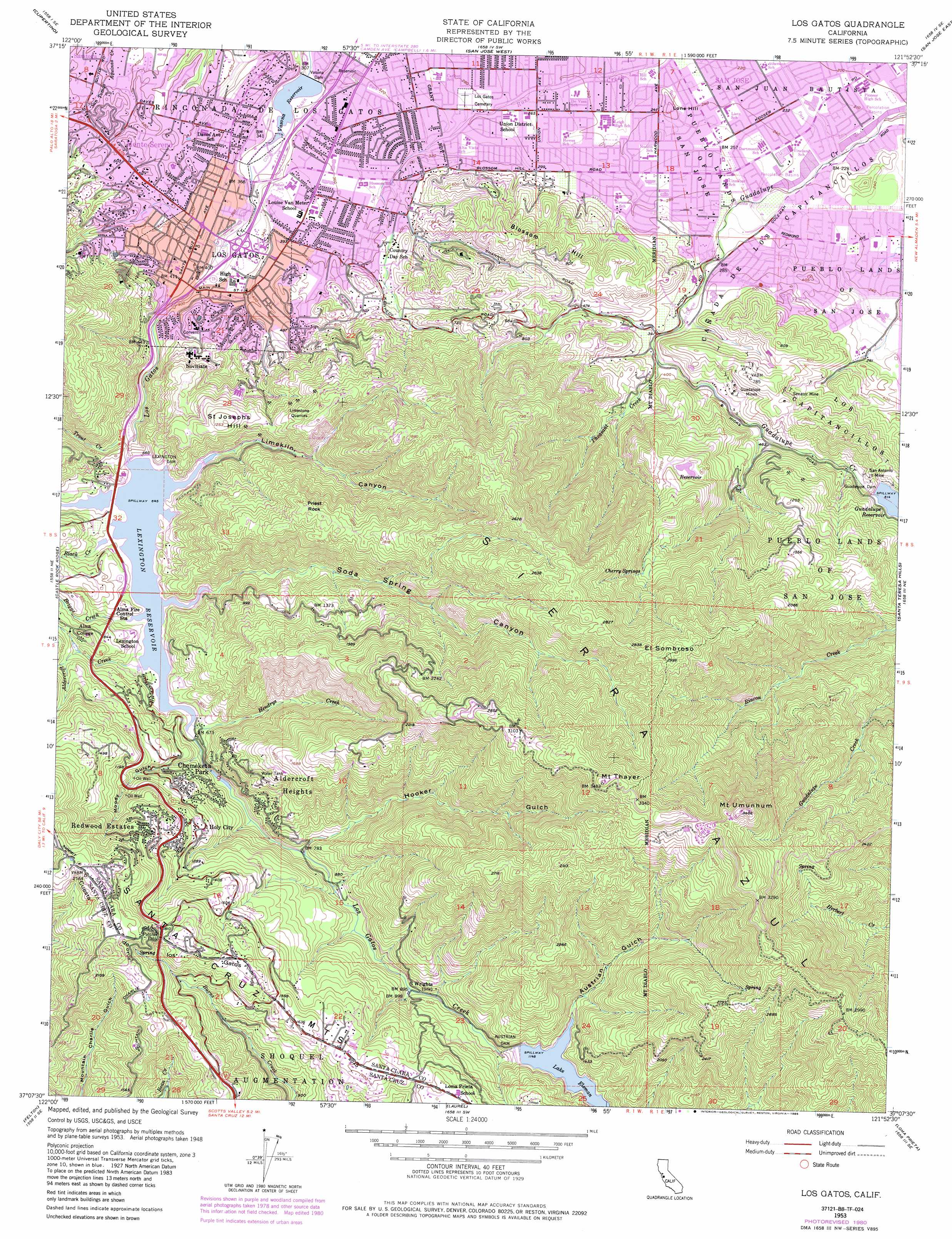
USGS Topo Quad 37121b8 - 1:24,000 scale
| Topo Map Name: | Los Gatos |
| USGS Topo Quad ID: | 37121b8 |
| Print Size: | ca. 21 1/4" wide x 27" high |
| Southeast Coordinates: | 37.125° N latitude / 121.875° W longitude |
| Map Center Coordinates: | 37.1875° N latitude / 121.9375° W longitude |
| U.S. State: | CA |
| Filename: | o37121b8.jpg |
| Download Map JPG Image: | Los Gatos topo map 1:24,000 scale |
| Map Type: | Topographic |
| Topo Series: | 7.5´ |
| Map Scale: | 1:24,000 |
| Source of Map Images: | United States Geological Survey (USGS) |
| Alternate Map Versions: |
Los Gatos CA 1953, updated 1955 Download PDF Buy paper map Los Gatos CA 1953, updated 1960 Download PDF Buy paper map Los Gatos CA 1953, updated 1966 Download PDF Buy paper map Los Gatos CA 1953, updated 1973 Download PDF Buy paper map Los Gatos CA 1953, updated 1975 Download PDF Buy paper map Los Gatos CA 1953, updated 1980 Download PDF Buy paper map Los Gatos CA 1953, updated 1985 Download PDF Buy paper map Los Gatos CA 2012 Download PDF Buy paper map Los Gatos CA 2015 Download PDF Buy paper map |
1:24,000 Topo Quads surrounding Los Gatos
Palo Alto |
Mountain View |
Milpitas |
Calaveras Reservoir |
Mount Day |
Mindego Hill |
Cupertino |
San Jose West |
San Jose East |
Lick Observatory |
Big Basin |
Castle Rock Ridge |
Los Gatos |
Santa Teresa Hills |
Morgan Hill |
Davenport |
Felton |
Laurel |
Loma Prieta |
Mount Madonna |
Santa Cruz |
Soquel |
Watsonville West |
Watsonville East |
> Back to 37121a1 at 1:100,000 scale
> Back to 37120a1 at 1:250,000 scale
> Back to U.S. Topo Maps home
Los Gatos topo map: Gazetteer
Los Gatos: Dams
Austrian Dam elevation 350m 1148′Guadalupe Dam elevation 188m 616′
Lexington Dam elevation 197m 646′
Ryland Dam elevation 213m 698′
Vasona Dam elevation 90m 295′
Los Gatos: Gaps
Patchen Pass elevation 561m 1840′Los Gatos: Lakes
Laguna del Sargento elevation 583m 1912′Los Gatos: Mines
Guadalupe Mines elevation 155m 508′Senator Mine elevation 162m 531′
Los Gatos: Parks
Almaden Meadows elevation 99m 324′Almaden Quicksivler County Park elevation 168m 551′
Almaden Winery Park elevation 79m 259′
Cerro Verde Park elevation 121m 396′
Guadalupe Oak Grove Park elevation 121m 396′
Helm Field elevation 108m 354′
Live Oak Manor Park elevation 99m 324′
Lone Hill Park elevation 73m 239′
Miller Memorial Park elevation 370m 1213′
Oak Meadow Park elevation 96m 314′
T J Martin Park elevation 78m 255′
Vasona Lake County Park elevation 94m 308′
Worcester Park elevation 135m 442′
Los Gatos: Pillars
Priest Rock elevation 534m 1751′Los Gatos: Populated Places
Aldercroft Heights elevation 312m 1023′Alma (historical) elevation 197m 646′
Austin elevation 133m 436′
Chemeketa Park elevation 309m 1013′
Guadalupe (historical) elevation 126m 413′
Holy City elevation 381m 1250′
Lexington (historical) elevation 197m 646′
Lexington Hills elevation 378m 1240′
Los Gatos elevation 105m 344′
Los Gatos Trailer Park elevation 109m 357′
Monte Sereno elevation 157m 515′
Redwood Estates elevation 495m 1624′
Rinconada elevation 121m 396′
Shannon elevation 114m 374′
Los Gatos: Post Offices
Los Gatos Post Office elevation 126m 413′Los Gatos: Ranges
Sierra Azul elevation 883m 2896′Los Gatos: Reservoirs
Guadalupe Reservoir elevation 188m 616′Lake Elsman elevation 350m 1148′
Lexington Reservoir elevation 197m 646′
Tisdale Reservoir elevation 164m 538′
Vasona Reservoir elevation 90m 295′
Los Gatos: Ridges
Cuesta de los Gatos elevation 659m 2162′Los Gatos: Springs
Cherry Springs elevation 497m 1630′Los Gatos: Streams
Aldercroft Creek elevation 198m 649′Black Creek elevation 199m 652′
Briggs Creek elevation 204m 669′
Hendrys Creek elevation 201m 659′
Pheasant Creek elevation 107m 351′
Trout Creek elevation 203m 666′
Los Gatos: Summits
Beehive elevation 673m 2208′Blossom Hill elevation 265m 869′
Collords Peak elevation 731m 2398′
El Sombroso elevation 912m 2992′
Lone Hill elevation 98m 321′
Mount Thayer elevation 1061m 3480′
Mount Umunhum elevation 1060m 3477′
Saint Josephs Hill elevation 377m 1236′
Los Gatos: Tunnels
Tunnel Number 1 elevation 481m 1578′Los Gatos: Valleys
Austrian Gulch elevation 350m 1148′Hooker Gulch elevation 259m 849′
Limekiln Canyon elevation 197m 646′
Lyndon Canyon elevation 198m 649′
Moody Gulch elevation 206m 675′
Soda Spring Canyon elevation 197m 646′
Los Gatos digital topo map on disk
Buy this Los Gatos topo map showing relief, roads, GPS coordinates and other geographical features, as a high-resolution digital map file on DVD: