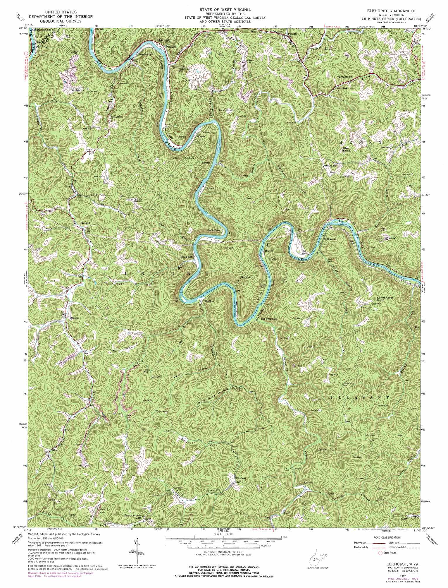
Elkhurst Topo Map West Virginia
To zoom in, hover over the map of Elkhurst
USGS Topo Quad 38081d2 - 1:24,000 scale
| Topo Map Name: | Elkhurst |
| USGS Topo Quad ID: | 38081d2 |
| Print Size: | ca. 21 1/4" wide x 27" high |
| Southeast Coordinates: | 38.375° N latitude / 81.125° W longitude |
| Map Center Coordinates: | 38.4375° N latitude / 81.1875° W longitude |
| U.S. State: | WV |
| Filename: | o38081d2.jpg |
| Download Map JPG Image: | Elkhurst topo map 1:24,000 scale |
| Map Type: | Topographic |
| Topo Series: | 7.5´ |
| Map Scale: | 1:24,000 |
| Source of Map Images: | United States Geological Survey (USGS) |
| Alternate Map Versions: |
Elkhurst WV 1967, updated 1968 Download PDF Buy paper map Elkhurst WV 1967, updated 1977 Download PDF Buy paper map Elkhurst WV 2011 Download PDF Buy paper map Elkhurst WV 2014 Download PDF Buy paper map Elkhurst WV 2016 Download PDF Buy paper map |
1:24,000 Topo Quads surrounding Elkhurst
Walton |
Looneyville |
Tariff |
Chloe |
Rosedale |
Kettle |
Clio |
Newton |
Ivydale |
Strange Creek |
Blue Creek |
Clendenin |
Elkhurst |
Clay |
Swandale |
Quick |
Mammoth |
Bentree |
Lockwood |
Gilboa |
Cedar Grove |
Montgomery |
Gauley Bridge |
Ansted |
Summersville Dam |
> Back to 38081a1 at 1:100,000 scale
> Back to 38080a1 at 1:250,000 scale
> Back to U.S. Topo Maps home
Elkhurst topo map: Gazetteer
Elkhurst: Bends
Jack Bend elevation 211m 692′Elkhurst: Gaps
Spruce Low Gap elevation 377m 1236′Elkhurst: Populated Places
Bomont elevation 253m 830′Dorfee elevation 206m 675′
Elkhurst elevation 207m 679′
Glen elevation 307m 1007′
Marne elevation 193m 633′
Odessa elevation 283m 928′
Paxton elevation 240m 787′
Procious elevation 198m 649′
Rouzer elevation 223m 731′
Shelton elevation 199m 652′
Varneytown elevation 247m 810′
Warfield elevation 313m 1026′
Elkhurst: Post Offices
Bomont Post Office elevation 259m 849′Glen Post Office elevation 311m 1020′
Procious Post Office elevation 193m 633′
Elkhurst: Springs
Hart Spring elevation 295m 967′Elkhurst: Streams
Beechy Creek elevation 205m 672′Birch Run elevation 203m 666′
Blue Knob Creek elevation 202m 662′
Buckhorn Fork elevation 302m 990′
Camp Creek elevation 188m 616′
Charley Branch elevation 233m 764′
Dulls Creek elevation 189m 620′
Horner Fork elevation 238m 780′
Laurel Creek elevation 191m 626′
Laurel Fork elevation 228m 748′
Left Fork Spruce Fork elevation 306m 1003′
Lick Run elevation 235m 770′
Little Beechy Creek elevation 200m 656′
Little Sycamore Creek elevation 196m 643′
Reed Fork elevation 240m 787′
Right Fork Spruce Fork elevation 306m 1003′
Summers Fork elevation 234m 767′
Sycamore Creek elevation 197m 646′
Twistabout Creek elevation 194m 636′
Twomile Branch elevation 203m 666′
Wade Fork elevation 204m 669′
Elkhurst: Summits
Blue Knob elevation 432m 1417′Schoonover Knob elevation 466m 1528′
Elkhurst: Valleys
Browncamp Hollow elevation 257m 843′Open Hollow elevation 250m 820′
Toms Hollow elevation 201m 659′
Elkhurst digital topo map on disk
Buy this Elkhurst topo map showing relief, roads, GPS coordinates and other geographical features, as a high-resolution digital map file on DVD:
Western Virginia & Southern West Virginia
Buy digital topo maps: Western Virginia & Southern West Virginia