Morehead Topo Map Kentucky
To zoom in, hover over the map of Morehead
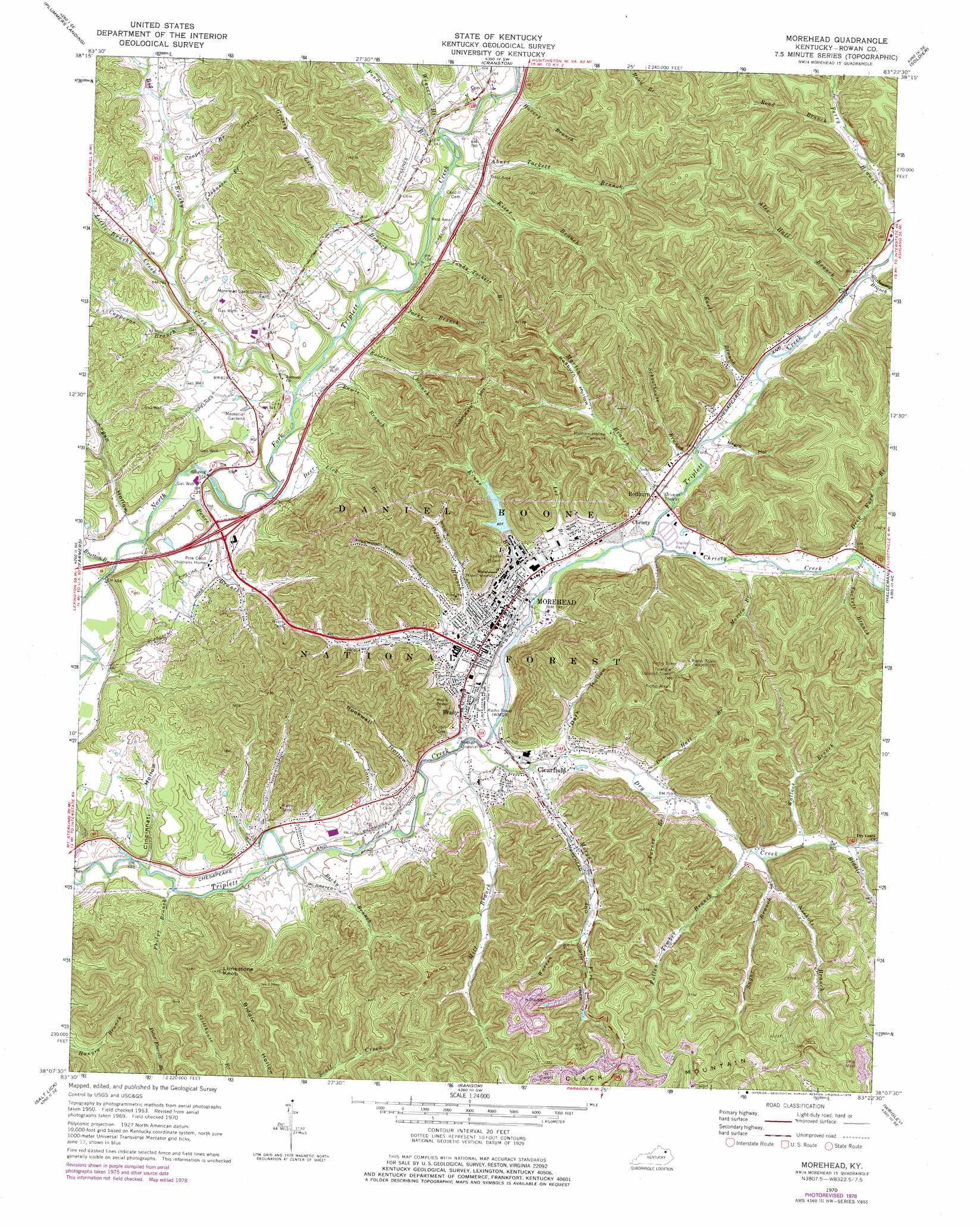
USGS Topo Quad 38083b4 - 1:24,000 scale
| Topo Map Name: | Morehead |
| USGS Topo Quad ID: | 38083b4 |
| Print Size: | ca. 21 1/4" wide x 27" high |
| Southeast Coordinates: | 38.125° N latitude / 83.375° W longitude |
| Map Center Coordinates: | 38.1875° N latitude / 83.4375° W longitude |
| U.S. State: | KY |
| Filename: | o38083b4.jpg |
| Download Map JPG Image: | Morehead topo map 1:24,000 scale |
| Map Type: | Topographic |
| Topo Series: | 7.5´ |
| Map Scale: | 1:24,000 |
| Source of Map Images: | United States Geological Survey (USGS) |
| Alternate Map Versions: |
Morehead KY 1953, updated 1955 Download PDF Buy paper map Morehead KY 1953, updated 1966 Download PDF Buy paper map Morehead KY 1970, updated 1972 Download PDF Buy paper map Morehead KY 1970, updated 1978 Download PDF Buy paper map Morehead KY 2011 Download PDF Buy paper map Morehead KY 2013 Download PDF Buy paper map Morehead KY 2016 Download PDF Buy paper map |
| FStopo: | US Forest Service topo Morehead is available: Download FStopo PDF Download FStopo TIF |
1:24,000 Topo Quads surrounding Morehead
Flemingsburg |
Burtonville |
Stricklett |
Head Of Grassy |
Wesleyville |
Hillsboro |
Plummers Landing |
Cranston |
Soldier |
Olive Hill |
Colfax |
Farmers |
Morehead |
Haldeman |
Ault |
Olympia |
Salt Lick |
Bangor |
Wrigley |
Sandy Hook |
Frenchburg |
Scranton |
Ezel |
West Liberty |
Lenox |
> Back to 38083a1 at 1:100,000 scale
> Back to 38082a1 at 1:250,000 scale
> Back to U.S. Topo Maps home
Morehead topo map: Gazetteer
Morehead: Cliffs
Amburgy Rocks elevation 304m 997′Morehead: Parks
Allen Field elevation 233m 764′Jayne Stadium elevation 228m 748′
University Softball Field elevation 236m 774′
Morehead: Populated Places
Brady elevation 223m 731′Christy elevation 234m 767′
Clearfield elevation 223m 731′
Morehead elevation 225m 738′
Rodburn elevation 232m 761′
Morehead: Streams
Abner Tackett Branch elevation 221m 725′Alec Hall Branch elevation 242m 793′
Becky Branch elevation 210m 688′
Big Brushy Creek elevation 215m 705′
Bratton Branch elevation 208m 682′
Christy Creek elevation 226m 741′
Cooper Branch elevation 245m 803′
Copperas Branch elevation 223m 731′
Dan Hall Branch elevation 228m 748′
Deep Ford Branch elevation 236m 774′
Deer Lick Branch elevation 213m 698′
Dry Creek elevation 219m 718′
Earls Branch elevation 235m 770′
Evans Branch elevation 220m 721′
Fallen Timber Branch elevation 238m 780′
Grassy Lick Branch elevation 223m 731′
Harvey Branch elevation 239m 784′
Jacks Branch elevation 216m 708′
Jane Branch elevation 241m 790′
Johnson Branch elevation 236m 774′
Kiser Branch elevation 222m 728′
Lambert Branch elevation 234m 767′
Lee Branch elevation 221m 725′
Little Brushy Creek elevation 226m 741′
Martin Branch elevation 232m 761′
Martin Branch elevation 232m 761′
Middle Prong Big Brushy Creek elevation 257m 843′
Mill Branch elevation 214m 702′
Morgan Fork elevation 214m 702′
Nichols Branch elevation 241m 790′
Oxley Branch elevation 218m 715′
Pence Branch elevation 208m 682′
Phelps Branch elevation 207m 679′
Pond Lick Branch elevation 219m 718′
Rawls Branch elevation 217m 711′
Riddle Fork elevation 253m 830′
Road Branch elevation 263m 862′
Roberts Branch elevation 219m 718′
Schoolhouse Branch elevation 232m 761′
Slabcamp Branch elevation 244m 800′
Sugar Branch elevation 242m 793′
Tackett Branch elevation 234m 767′
Tandy Tackett Branch elevation 227m 744′
Turner Branch elevation 231m 757′
Wallace Branch elevation 244m 800′
Warren Branch elevation 251m 823′
Weaver Branch elevation 220m 721′
Morehead: Summits
Clack Mountain elevation 400m 1312′Limestone Knob elevation 433m 1420′
Morehead: Trails
Big Limestone Trail elevation 371m 1217′Morehead: Valleys
Cincinnati Hollow elevation 208m 682′Dark Hollow elevation 228m 748′
Logan Hollow elevation 212m 695′
Negro Hollow elevation 236m 774′
Rockwall Hollow elevation 219m 718′
Rodburn Hollow elevation 249m 816′
Morehead digital topo map on disk
Buy this Morehead topo map showing relief, roads, GPS coordinates and other geographical features, as a high-resolution digital map file on DVD:
Western Virginia & Southern West Virginia
Buy digital topo maps: Western Virginia & Southern West Virginia