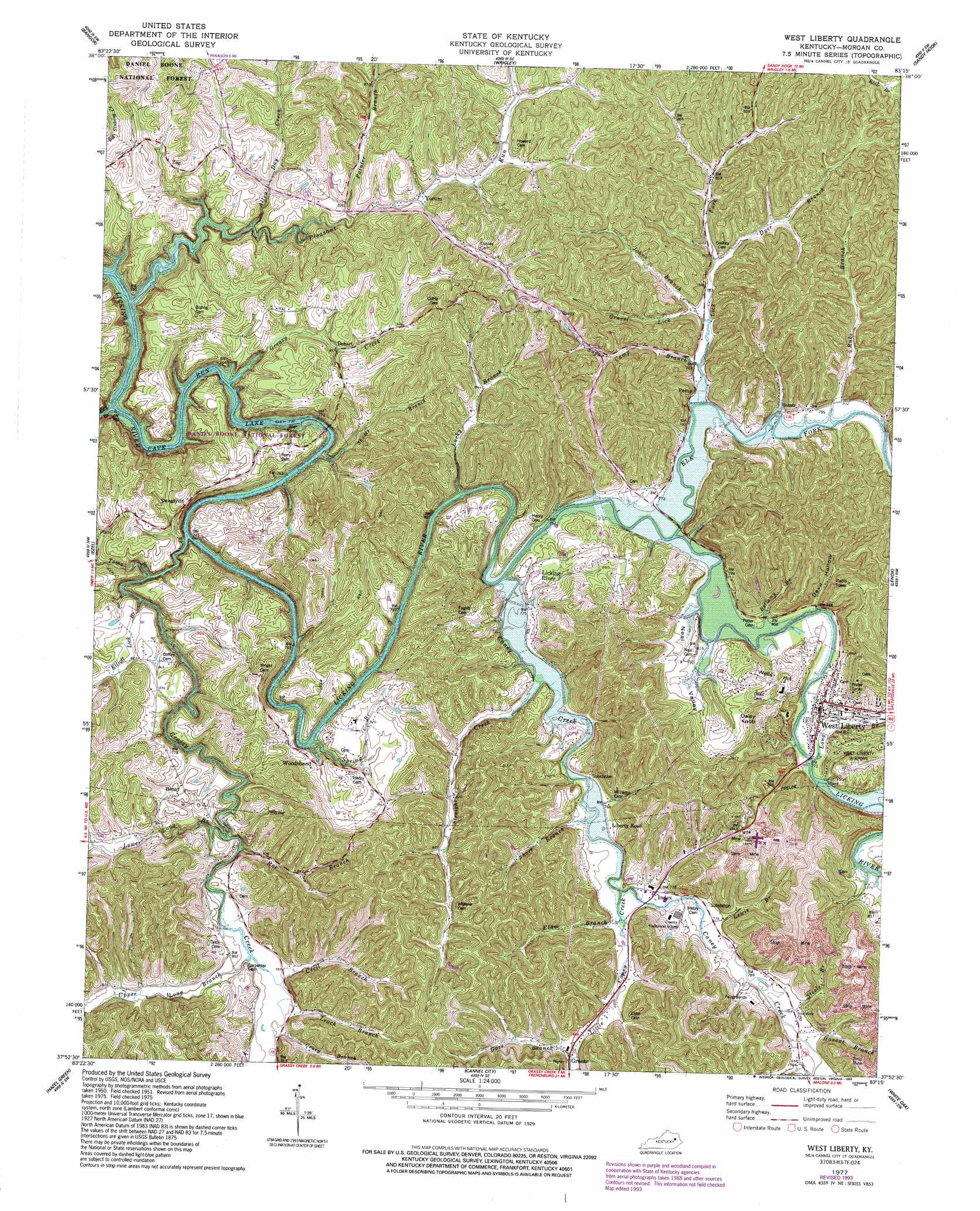
West Liberty Topo Map Kentucky
To zoom in, hover over the map of West Liberty
USGS Topo Quad 37083h3 - 1:24,000 scale
| Topo Map Name: | West Liberty |
| USGS Topo Quad ID: | 37083h3 |
| Print Size: | ca. 21 1/4" wide x 27" high |
| Southeast Coordinates: | 37.875° N latitude / 83.25° W longitude |
| Map Center Coordinates: | 37.9375° N latitude / 83.3125° W longitude |
| U.S. State: | KY |
| Filename: | o37083h3.jpg |
| Download Map JPG Image: | West Liberty topo map 1:24,000 scale |
| Map Type: | Topographic |
| Topo Series: | 7.5´ |
| Map Scale: | 1:24,000 |
| Source of Map Images: | United States Geological Survey (USGS) |
| Alternate Map Versions: |
West Liberty KY 1951, updated 1953 Download PDF Buy paper map West Liberty KY 1951, updated 1972 Download PDF Buy paper map West Liberty KY 1977, updated 1978 Download PDF Buy paper map West Liberty KY 1977, updated 1993 Download PDF Buy paper map West Liberty KY 2011 Download PDF Buy paper map West Liberty KY 2013 Download PDF Buy paper map West Liberty KY 2016 Download PDF Buy paper map |
| FStopo: | US Forest Service topo West Liberty is available: Download FStopo PDF Download FStopo TIF |
1:24,000 Topo Quads surrounding West Liberty
Farmers |
Morehead |
Haldeman |
Ault |
Bruin |
Salt Lick |
Bangor |
Wrigley |
Sandy Hook |
Isonville |
Scranton |
Ezel |
West Liberty |
Lenox |
Dingus |
Pomeroyton |
Hazel Green |
Cannel City |
White Oak |
Salyersville North |
Campton |
Landsaw |
Lee City |
Seitz |
Salyersville South |
> Back to 37083e1 at 1:100,000 scale
> Back to 37082a1 at 1:250,000 scale
> Back to U.S. Topo Maps home
West Liberty topo map: Gazetteer
West Liberty: Airports
West Liberty Airport elevation 276m 905′West Liberty: Bridges
Mussel Shoals Bridge (historical) elevation 220m 721′West Liberty: Populated Places
Bear Wallow elevation 263m 862′Bonny elevation 281m 921′
Dehart elevation 267m 875′
Fannin elevation 297m 974′
Greear elevation 244m 800′
Index elevation 237m 777′
Liberty Road elevation 237m 777′
Licking River elevation 243m 797′
Neal Valley elevation 238m 780′
Perry Bend elevation 263m 862′
Pomp elevation 230m 754′
Straight Creek elevation 244m 800′
Twentysix elevation 279m 915′
West Liberty elevation 249m 816′
Woodsbend elevation 255m 836′
Yocum elevation 246m 807′
Zag elevation 290m 951′
West Liberty: Post Offices
Bonny Post Office (historical) elevation 255m 836′Greear Post Office (historical) elevation 243m 797′
Hamptons Mill Post Office (historical) elevation 230m 754′
Henry Post Office elevation 256m 839′
Index Post Office (historical) elevation 237m 777′
Jeston Post Office (historical) elevation 303m 994′
Lemon Post Office (historical) elevation 231m 757′
Liberty Road Post Office (historical) elevation 237m 777′
Licking River Post Office (historical) elevation 244m 800′
New Cummer Post Office (historical) elevation 257m 843′
Pomp Post Office (historical) elevation 238m 780′
Twenty Six Post Office (historical) elevation 281m 921′
Woodsbend Post Office (historical) elevation 250m 820′
Zag Post Office (historical) elevation 293m 961′
West Liberty: Streams
Allen Day Creek elevation 236m 774′Barker Branch elevation 239m 784′
Bellamy Branch elevation 226m 741′
Caney Creek elevation 226m 741′
Carpenter Branch elevation 243m 797′
Cecil Branch elevation 234m 767′
Cruey Branch elevation 234m 767′
Dyer Branch elevation 237m 777′
Elam Branch elevation 236m 774′
Elk Fork elevation 226m 741′
Elliott Lick Branch elevation 224m 734′
Gose Branch elevation 243m 797′
Grassy Creek elevation 220m 721′
Gravel Lick elevation 237m 777′
Greasy Creek elevation 220m 721′
Havens Branch elevation 238m 780′
Johns Branch elevation 235m 770′
Kay Branch elevation 220m 721′
Leach Branch elevation 236m 774′
Lewis Branch elevation 235m 770′
Lick Fork elevation 227m 744′
Lick Fork elevation 228m 748′
Little Caney Creek elevation 232m 761′
Long Branch elevation 231m 757′
Lower Long Branch elevation 230m 754′
Lucky Branch elevation 226m 741′
Painter Branch elevation 241m 790′
Pleasant Run elevation 220m 721′
Roe Branch elevation 243m 797′
Rube Branch elevation 231m 757′
Shoals Branch elevation 220m 721′
Short Branch elevation 231m 757′
Spring Branch elevation 226m 741′
Steele Branch elevation 237m 777′
Straight Creek elevation 226m 741′
Sugar Camp Branch elevation 232m 761′
Toms Branch elevation 224m 734′
Upper Long Branch elevation 235m 770′
West Liberty: Summits
Daisy Knob elevation 310m 1017′McClannahan Hill elevation 342m 1122′
Wells Hill elevation 275m 902′
West Liberty: Valleys
Devil Hollow elevation 230m 754′Neal Valley elevation 234m 767′
West Liberty digital topo map on disk
Buy this West Liberty topo map showing relief, roads, GPS coordinates and other geographical features, as a high-resolution digital map file on DVD:
Western Virginia & Southern West Virginia
Buy digital topo maps: Western Virginia & Southern West Virginia