Ezel Topo Map Kentucky
To zoom in, hover over the map of Ezel
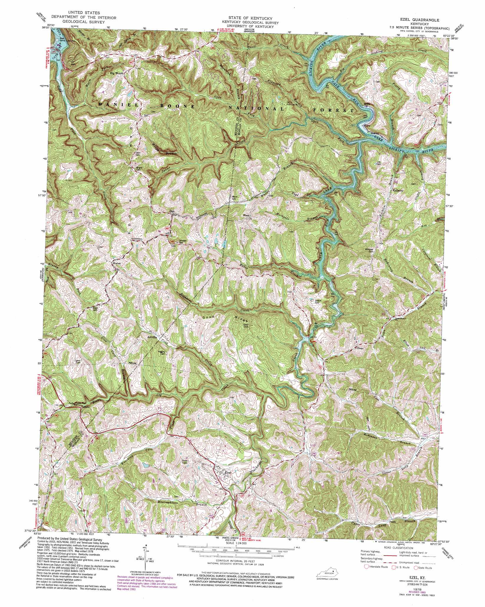
USGS Topo Quad 37083h4 - 1:24,000 scale
| Topo Map Name: | Ezel |
| USGS Topo Quad ID: | 37083h4 |
| Print Size: | ca. 21 1/4" wide x 27" high |
| Southeast Coordinates: | 37.875° N latitude / 83.375° W longitude |
| Map Center Coordinates: | 37.9375° N latitude / 83.4375° W longitude |
| U.S. State: | KY |
| Filename: | o37083h4.jpg |
| Download Map JPG Image: | Ezel topo map 1:24,000 scale |
| Map Type: | Topographic |
| Topo Series: | 7.5´ |
| Map Scale: | 1:24,000 |
| Source of Map Images: | United States Geological Survey (USGS) |
| Alternate Map Versions: |
Ezel KY 1951, updated 1953 Download PDF Buy paper map Ezel KY 1951, updated 1968 Download PDF Buy paper map Ezel KY 1978, updated 1978 Download PDF Buy paper map Ezel KY 1978, updated 1993 Download PDF Buy paper map Ezel KY 2011 Download PDF Buy paper map Ezel KY 2013 Download PDF Buy paper map Ezel KY 2016 Download PDF Buy paper map |
| FStopo: | US Forest Service topo Ezel is available: Download FStopo PDF Download FStopo TIF |
1:24,000 Topo Quads surrounding Ezel
Colfax |
Farmers |
Morehead |
Haldeman |
Ault |
Olympia |
Salt Lick |
Bangor |
Wrigley |
Sandy Hook |
Frenchburg |
Scranton |
Ezel |
West Liberty |
Lenox |
Slade |
Pomeroyton |
Hazel Green |
Cannel City |
White Oak |
Zachariah |
Campton |
Landsaw |
Lee City |
Seitz |
> Back to 37083e1 at 1:100,000 scale
> Back to 37082a1 at 1:250,000 scale
> Back to U.S. Topo Maps home
Ezel topo map: Gazetteer
Ezel: Falls
Broken Leg Falls elevation 321m 1053′Ezel: Populated Places
Artville elevation 299m 980′Back elevation 354m 1161′
Big Woods elevation 376m 1233′
Craft elevation 377m 1236′
Dan elevation 347m 1138′
Ebon elevation 316m 1036′
Ezel elevation 288m 944′
Jericho elevation 266m 872′
Kellacey elevation 287m 941′
Korea elevation 341m 1118′
Pekin elevation 269m 882′
Pine Grove elevation 302m 990′
Ezel: Post Offices
Apple Post Office (historical) elevation 299m 980′Arnette Post Office (historical) elevation 220m 721′
Artville Post Office (historical) elevation 298m 977′
Big Woods Post Office (historical) elevation 373m 1223′
Dan Post Office (historical) elevation 309m 1013′
Ebon Post Office (historical) elevation 301m 987′
Elder Post Office (historical) elevation 286m 938′
Ezel Post Office elevation 282m 925′
Kellancey Post Office (historical) elevation 221m 725′
Korea Post Office (historical) elevation 347m 1138′
Murphy Post Office (historical) elevation 267m 875′
Omer Post Office (historical) elevation 276m 905′
Pekin Post Office (historical) elevation 267m 875′
Swetnam Post Office (historical) elevation 322m 1056′
Ezel: Ridges
Dan Ridge elevation 336m 1102′Goad Ridge elevation 312m 1023′
Ezel: Streams
Baldwin Creek elevation 227m 744′Big Sinking Creek elevation 237m 777′
Black Fork elevation 254m 833′
Blackwater Creek elevation 220m 721′
Broke Leg Creek elevation 237m 777′
Cold Cave Creek elevation 220m 721′
Coon Creek elevation 256m 839′
Devil Creek elevation 226m 741′
Eaton Creek elevation 221m 725′
Flaxseed Branch elevation 224m 734′
Gladie Branch elevation 225m 738′
Greasy Fork elevation 249m 816′
Hookpole Branch elevation 229m 751′
Knocking Cave Creek elevation 250m 820′
Lion Cave Branch elevation 258m 846′
McKinney Branch elevation 251m 823′
Meetinghouse Branch elevation 251m 823′
Open Fork elevation 220m 721′
Pretty Branch elevation 228m 748′
Ragstand Branch elevation 264m 866′
Robinson Branch elevation 260m 853′
Rough Branch elevation 258m 846′
Sage Branch elevation 220m 721′
Spaws Creek elevation 233m 764′
Tarkiln Branch elevation 234m 767′
Vest Branch elevation 258m 846′
Warm Fork elevation 231m 757′
Whites Branch elevation 220m 721′
Ezel digital topo map on disk
Buy this Ezel topo map showing relief, roads, GPS coordinates and other geographical features, as a high-resolution digital map file on DVD:
Western Virginia & Southern West Virginia
Buy digital topo maps: Western Virginia & Southern West Virginia