Ault Topo Map Kentucky
To zoom in, hover over the map of Ault
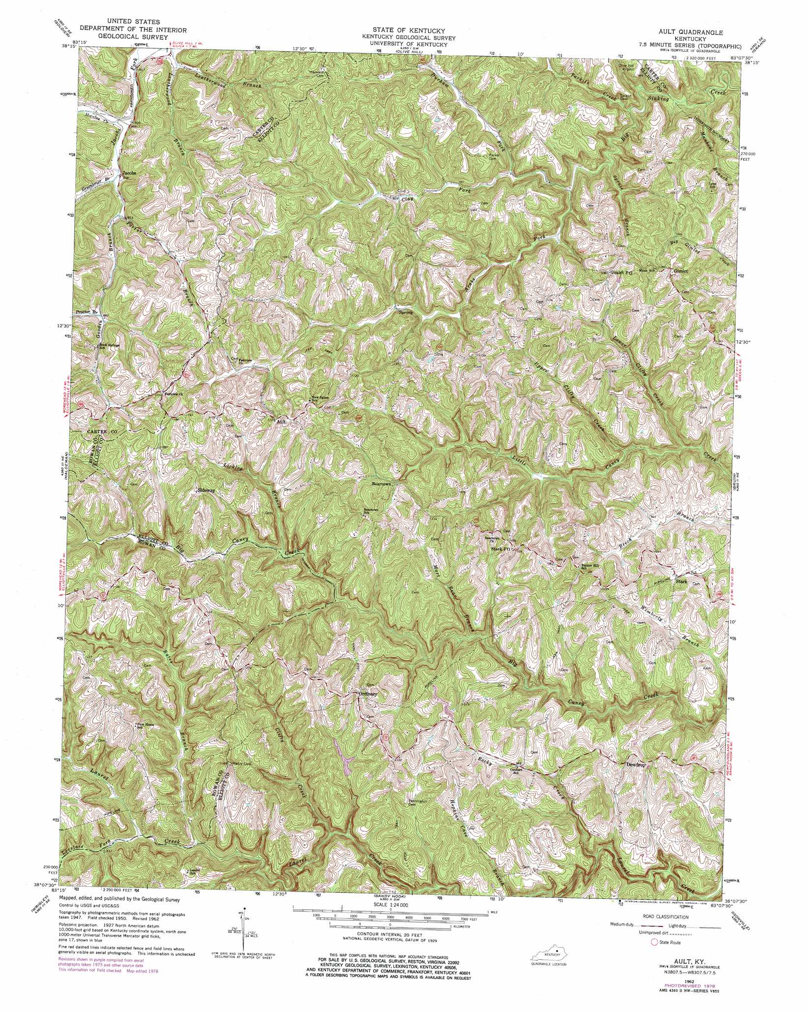
USGS Topo Quad 38083b2 - 1:24,000 scale
| Topo Map Name: | Ault |
| USGS Topo Quad ID: | 38083b2 |
| Print Size: | ca. 21 1/4" wide x 27" high |
| Southeast Coordinates: | 38.125° N latitude / 83.125° W longitude |
| Map Center Coordinates: | 38.1875° N latitude / 83.1875° W longitude |
| U.S. State: | KY |
| Filename: | o38083b2.jpg |
| Download Map JPG Image: | Ault topo map 1:24,000 scale |
| Map Type: | Topographic |
| Topo Series: | 7.5´ |
| Map Scale: | 1:24,000 |
| Source of Map Images: | United States Geological Survey (USGS) |
| Alternate Map Versions: |
Ault KY 1950, updated 1952 Download PDF Buy paper map Ault KY 1962, updated 1964 Download PDF Buy paper map Ault KY 1962, updated 1978 Download PDF Buy paper map Ault KY 2010 Download PDF Buy paper map Ault KY 2013 Download PDF Buy paper map Ault KY 2016 Download PDF Buy paper map |
1:24,000 Topo Quads surrounding Ault
Stricklett |
Head Of Grassy |
Wesleyville |
Tygarts Valley |
Oldtown |
Cranston |
Soldier |
Olive Hill |
Grahn |
Grayson |
Morehead |
Haldeman |
Ault |
Bruin |
Willard |
Bangor |
Wrigley |
Sandy Hook |
Isonville |
Mazie |
Ezel |
West Liberty |
Lenox |
Dingus |
Redbush |
> Back to 38083a1 at 1:100,000 scale
> Back to 38082a1 at 1:250,000 scale
> Back to U.S. Topo Maps home
Ault topo map: Gazetteer
Ault: Crossings
Fannin Crossing elevation 331m 1085′Ault: Populated Places
Ault elevation 344m 1128′Beartown elevation 281m 921′
Clay Fork elevation 244m 800′
Dewdrop elevation 318m 1043′
Fannin Valley elevation 251m 823′
Gimlet elevation 336m 1102′
Globe Community elevation 313m 1026′
Jacobs elevation 256m 839′
Offill's Mill (historical) elevation 250m 820′
Ordinary elevation 340m 1115′
Shady Grove elevation 266m 872′
Sideway elevation 355m 1164′
Stark elevation 284m 931′
Ault: Post Offices
Ault Post Office (historical) elevation 321m 1053′Clayton Post Office (historical) elevation 251m 823′
Conn Post Office (historical) elevation 227m 744′
Dew Drop Post Office (historical) elevation 316m 1036′
Forks of Tygarts Post Office (historical) elevation 248m 813′
Gimlet Post Office elevation 332m 1089′
Jacobs Post Office (historical) elevation 258m 846′
Leadingham Post Office (historical) elevation 283m 928′
Longway Post Office (historical) elevation 356m 1167′
Ordinary Post Office (historical) elevation 338m 1108′
Sideway Post Office (historical) elevation 355m 1164′
Stark Post Office elevation 337m 1105′
Winkler Post Office (historical) elevation 274m 898′
Ault: Ridges
Brown Ridge elevation 330m 1082′Henderson Ridge (historical) elevation 339m 1112′
Mabry Ridge elevation 356m 1167′
Mauk Ridge elevation 339m 1112′
Stamper Ridge elevation 333m 1092′
Ault: Streams
Arabs Fork elevation 231m 757′Bates Branch elevation 241m 790′
Birch Branch elevation 232m 761′
Brown Fork elevation 266m 872′
Clay Fork elevation 222m 728′
Clifty Creek elevation 233m 764′
Durham Fork elevation 235m 770′
Goodin Branch elevation 257m 843′
Greenbrier Branch elevation 255m 836′
Leatherwood Branch elevation 247m 810′
Licklog Branch elevation 248m 813′
Lovelace Fork elevation 244m 800′
Lower Clifty Creek elevation 217m 711′
Manbone Branch elevation 212m 695′
Mart Bear Branch elevation 228m 748′
Mart Whitt Fork elevation 234m 767′
Mocabee Creek elevation 249m 816′
Porter Branch elevation 256m 839′
Proctor Branch elevation 268m 879′
Rocky Creek elevation 211m 692′
Spruce Branch elevation 223m 731′
Tarkiln Creek elevation 217m 711′
Upper Clifty Creek elevation 219m 718′
Wimberly Branch elevation 220m 721′
Ault: Woods
Highland Forest elevation 280m 918′Ault digital topo map on disk
Buy this Ault topo map showing relief, roads, GPS coordinates and other geographical features, as a high-resolution digital map file on DVD:
Western Virginia & Southern West Virginia
Buy digital topo maps: Western Virginia & Southern West Virginia