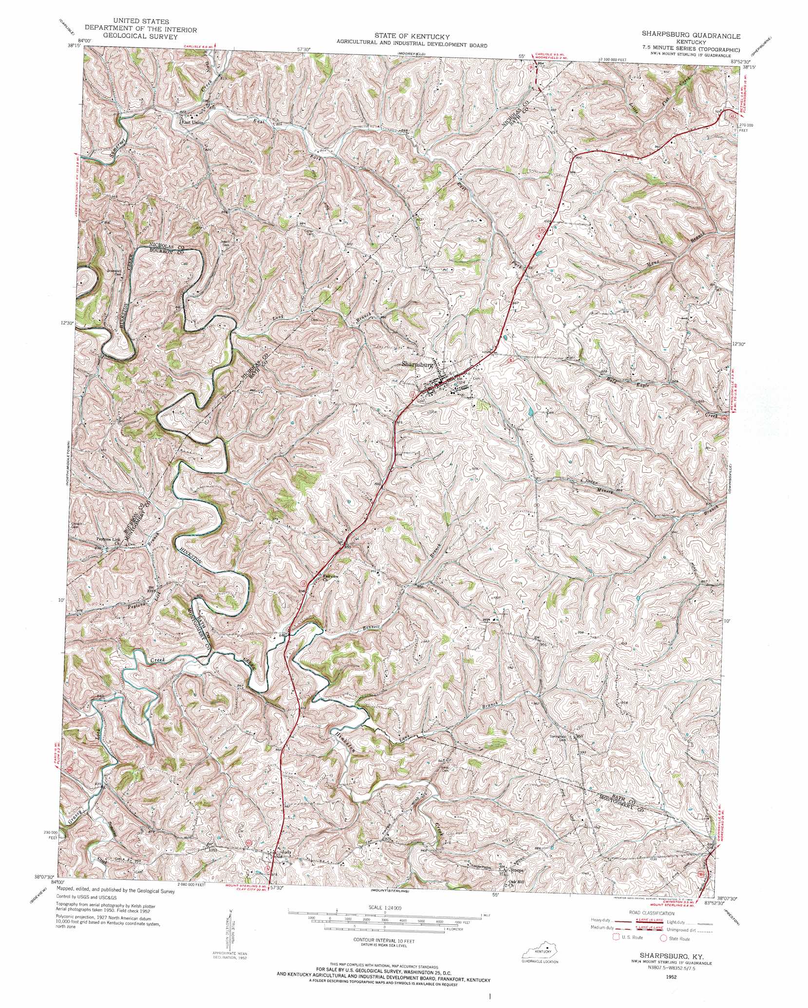
Sharpsburg Topo Map Kentucky
To zoom in, hover over the map of Sharpsburg
USGS Topo Quad 38083b8 - 1:24,000 scale
| Topo Map Name: | Sharpsburg |
| USGS Topo Quad ID: | 38083b8 |
| Print Size: | ca. 21 1/4" wide x 27" high |
| Southeast Coordinates: | 38.125° N latitude / 83.875° W longitude |
| Map Center Coordinates: | 38.1875° N latitude / 83.9375° W longitude |
| U.S. State: | KY |
| Filename: | o38083b8.jpg |
| Download Map JPG Image: | Sharpsburg topo map 1:24,000 scale |
| Map Type: | Topographic |
| Topo Series: | 7.5´ |
| Map Scale: | 1:24,000 |
| Source of Map Images: | United States Geological Survey (USGS) |
| Alternate Map Versions: |
Sharpsburg KY 1952, updated 1953 Download PDF Buy paper map Sharpsburg KY 2010 Download PDF Buy paper map Sharpsburg KY 2013 Download PDF Buy paper map Sharpsburg KY 2016 Download PDF Buy paper map |
1:24,000 Topo Quads surrounding Sharpsburg
Shady Nook |
Piqua |
Cowan |
Elizaville |
Flemingsburg |
Millersburg |
Carlisle |
Moorefield |
Sherburne |
Hillsboro |
Paris East |
North Middletown |
Sharpsburg |
Owingsville |
Colfax |
Austerlitz |
Sideview |
Mount Sterling |
Preston |
Olympia |
Winchester |
Hedges |
Levee |
Means |
Frenchburg |
> Back to 38083a1 at 1:100,000 scale
> Back to 38082a1 at 1:250,000 scale
> Back to U.S. Topo Maps home
Sharpsburg topo map: Gazetteer
Sharpsburg: Populated Places
East Union elevation 260m 853′Fairview elevation 293m 961′
Judy elevation 305m 1000′
Oaklawn Subdivision elevation 315m 1033′
Peytons elevation 262m 859′
Sharpsburg elevation 308m 1010′
Stoops elevation 297m 974′
Sharpsburg: Post Offices
Carters Store Post Office (historical) elevation 294m 964′East Union Post Office (historical) elevation 263m 862′
Judy Post Office (historical) elevation 305m 1000′
Stoops Post Office (historical) elevation 295m 967′
Sharpsburg: Reservoirs
Flemings Pond elevation 301m 987′Sharpsburg: Streams
Bennett Branch elevation 252m 826′East Fork Somerset Creek elevation 247m 810′
Grassy Lick Creek elevation 245m 803′
Lane Branch elevation 253m 830′
Long Branch elevation 246m 807′
North Fork Somerset Creek elevation 254m 833′
Peytons Lick Branch elevation 246m 807′
Somerset Creek elevation 253m 830′
Town Branch elevation 250m 820′
Sharpsburg digital topo map on disk
Buy this Sharpsburg topo map showing relief, roads, GPS coordinates and other geographical features, as a high-resolution digital map file on DVD:
Western Virginia & Southern West Virginia
Buy digital topo maps: Western Virginia & Southern West Virginia