Means Topo Map Kentucky
To zoom in, hover over the map of Means
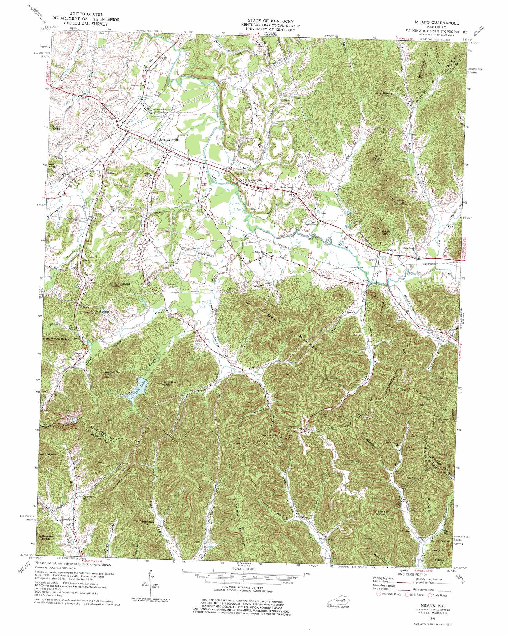
USGS Topo Quad 37083h7 - 1:24,000 scale
| Topo Map Name: | Means |
| USGS Topo Quad ID: | 37083h7 |
| Print Size: | ca. 21 1/4" wide x 27" high |
| Southeast Coordinates: | 37.875° N latitude / 83.75° W longitude |
| Map Center Coordinates: | 37.9375° N latitude / 83.8125° W longitude |
| U.S. State: | KY |
| Filename: | o37083h7.jpg |
| Download Map JPG Image: | Means topo map 1:24,000 scale |
| Map Type: | Topographic |
| Topo Series: | 7.5´ |
| Map Scale: | 1:24,000 |
| Source of Map Images: | United States Geological Survey (USGS) |
| Alternate Map Versions: |
Means KY 1952, updated 1953 Download PDF Buy paper map Means KY 1952, updated 1967 Download PDF Buy paper map Means KY 1975, updated 1977 Download PDF Buy paper map Means KY 2011 Download PDF Buy paper map Means KY 2013 Download PDF Buy paper map Means KY 2016 Download PDF Buy paper map |
| FStopo: | US Forest Service topo Means is available: Download FStopo PDF Download FStopo TIF |
1:24,000 Topo Quads surrounding Means
North Middletown |
Sharpsburg |
Owingsville |
Colfax |
Farmers |
Sideview |
Mount Sterling |
Preston |
Olympia |
Salt Lick |
Hedges |
Levee |
Means |
Frenchburg |
Scranton |
Palmer |
Clay City |
Stanton |
Slade |
Pomeroyton |
Panola |
Irvine |
Cobhill |
Zachariah |
Campton |
> Back to 37083e1 at 1:100,000 scale
> Back to 37082a1 at 1:250,000 scale
> Back to U.S. Topo Maps home
Means topo map: Gazetteer
Means: Lakes
Sid Calk Lake elevation 282m 925′Means: Populated Places
Camp Branch elevation 247m 810′Jeffersonville elevation 249m 816′
Judy elevation 241m 790′
Lucky Stop elevation 276m 905′
Means elevation 259m 849′
Morris Creek elevation 217m 711′
Rebelsville elevation 257m 843′
Salem elevation 251m 823′
Willoughby Nation elevation 255m 836′
Means: Post Offices
Bean Post Office (historical) elevation 271m 889′Boone Post Office (historical) elevation 255m 836′
Cash Knob Post Office (historical) elevation 261m 856′
Cedar Grove Post Office (historical) elevation 262m 859′
Jeffersonville Post Office elevation 248m 813′
Means Post Office elevation 262m 859′
Mountaview Post Office (historical) elevation 250m 820′
Means: Ridges
Bowen Ridge elevation 320m 1049′Persimmon Ridge elevation 318m 1043′
Science Ridge elevation 275m 902′
Means: Streams
Anders Branch elevation 230m 754′Barnett Branch elevation 262m 859′
Bird Branch elevation 252m 826′
Camp Branch elevation 239m 784′
Cave Branch elevation 257m 843′
Clay Lick Branch elevation 244m 800′
Cooks Branch elevation 250m 820′
Cooks Branch Slate elevation 244m 800′
Dogtrot Branch elevation 263m 862′
East Fork Slate Creek elevation 250m 820′
Ficklin Fork elevation 243m 797′
Hawkins Branch elevation 250m 820′
Long Branch elevation 238m 780′
Lower Spruce Creek elevation 247m 810′
Martin Fork elevation 244m 800′
Middle Fork Right Fork Cane Creek elevation 221m 725′
Plum Tree Branch elevation 265m 869′
Rocky Branch elevation 241m 790′
Safferty Branch elevation 276m 905′
South Fork Upper Spruce Creek elevation 250m 820′
Spruce Creek elevation 243m 797′
Spruce Creek elevation 243m 797′
Upper Spruce Creek elevation 247m 810′
West Fork Slate Creek elevation 254m 833′
Willoughby Fork elevation 245m 803′
Means: Summits
Big Round Mountain elevation 349m 1145′Cedar Knob elevation 390m 1279′
Chimney Rocks elevation 397m 1302′
Congleton Mountain elevation 391m 1282′
Gibson Knob elevation 286m 938′
Hickory Knob elevation 349m 1145′
Horselick Knob elevation 391m 1282′
Johnson Knob elevation 386m 1266′
Kashs Knob elevation 391m 1282′
Little Round Mountain elevation 346m 1135′
Popular Mountain elevation 383m 1256′
Sand Mountain elevation 367m 1204′
Stevens Knob elevation 336m 1102′
Turkey Knob elevation 376m 1233′
Wagon Bed Knob elevation 390m 1279′
Wildcat Mountain elevation 400m 1312′
Means: Valleys
Gibson Hollow elevation 246m 807′Hedger Hollow elevation 230m 754′
Napier Hollow elevation 238m 780′
Pottersville Hollow elevation 276m 905′
Pumpkin Hollow elevation 246m 807′
Means digital topo map on disk
Buy this Means topo map showing relief, roads, GPS coordinates and other geographical features, as a high-resolution digital map file on DVD:
Western Virginia & Southern West Virginia
Buy digital topo maps: Western Virginia & Southern West Virginia