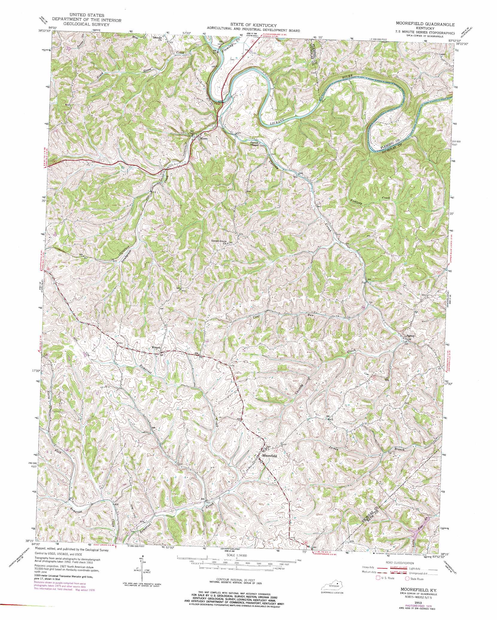
Moorefield Topo Map Kentucky
To zoom in, hover over the map of Moorefield
USGS Topo Quad 38083c8 - 1:24,000 scale
| Topo Map Name: | Moorefield |
| USGS Topo Quad ID: | 38083c8 |
| Print Size: | ca. 21 1/4" wide x 27" high |
| Southeast Coordinates: | 38.25° N latitude / 83.875° W longitude |
| Map Center Coordinates: | 38.3125° N latitude / 83.9375° W longitude |
| U.S. State: | KY |
| Filename: | o38083c8.jpg |
| Download Map JPG Image: | Moorefield topo map 1:24,000 scale |
| Map Type: | Topographic |
| Topo Series: | 7.5´ |
| Map Scale: | 1:24,000 |
| Source of Map Images: | United States Geological Survey (USGS) |
| Alternate Map Versions: |
Moorefield KY 1953, updated 1954 Download PDF Buy paper map Moorefield KY 1953, updated 1978 Download PDF Buy paper map Moorefield KY 2010 Download PDF Buy paper map Moorefield KY 2013 Download PDF Buy paper map Moorefield KY 2016 Download PDF Buy paper map |
1:24,000 Topo Quads surrounding Moorefield
Claysville |
Mount Olivet |
Sardis |
Mays Lick |
Orangeburg |
Shady Nook |
Piqua |
Cowan |
Elizaville |
Flemingsburg |
Millersburg |
Carlisle |
Moorefield |
Sherburne |
Hillsboro |
Paris East |
North Middletown |
Sharpsburg |
Owingsville |
Colfax |
Austerlitz |
Sideview |
Mount Sterling |
Preston |
Olympia |
> Back to 38083a1 at 1:100,000 scale
> Back to 38082a1 at 1:250,000 scale
> Back to U.S. Topo Maps home
Moorefield topo map: Gazetteer
Moorefield: Bridges
Licking River Bridge elevation 180m 590′Moorefield: Crossings
Parks Ferry (historical) elevation 175m 574′Moorefield: Parks
Clay Wildlife Management Area elevation 246m 807′Moorefield: Populated Places
Moorefield elevation 301m 987′Myers elevation 191m 626′
Sprout elevation 229m 751′
Weston elevation 298m 977′
Moorefield: Post Offices
Blackhawk Post Office (historical) elevation 188m 616′Cassidys Crick Post Office (historical) elevation 190m 623′
Marengo Post Office (historical) elevation 203m 666′
Miranda Post Office (historical) elevation 301m 987′
Moorefield Post Office (historical) elevation 299m 980′
Myersville Post Office (historical) elevation 227m 744′
Sprout Post Office (historical) elevation 232m 761′
Weston Post Office (historical) elevation 305m 1000′
Moorefield: Streams
Cane Run elevation 216m 708′Cassidy Creek elevation 177m 580′
Fishtrap Creek elevation 185m 606′
Fleming Creek elevation 183m 600′
Scrubgrass Creek elevation 180m 590′
South Goose Creek elevation 178m 583′
Moorefield digital topo map on disk
Buy this Moorefield topo map showing relief, roads, GPS coordinates and other geographical features, as a high-resolution digital map file on DVD:
Western Virginia & Southern West Virginia
Buy digital topo maps: Western Virginia & Southern West Virginia