Bedford Topo Map Kentucky
To zoom in, hover over the map of Bedford
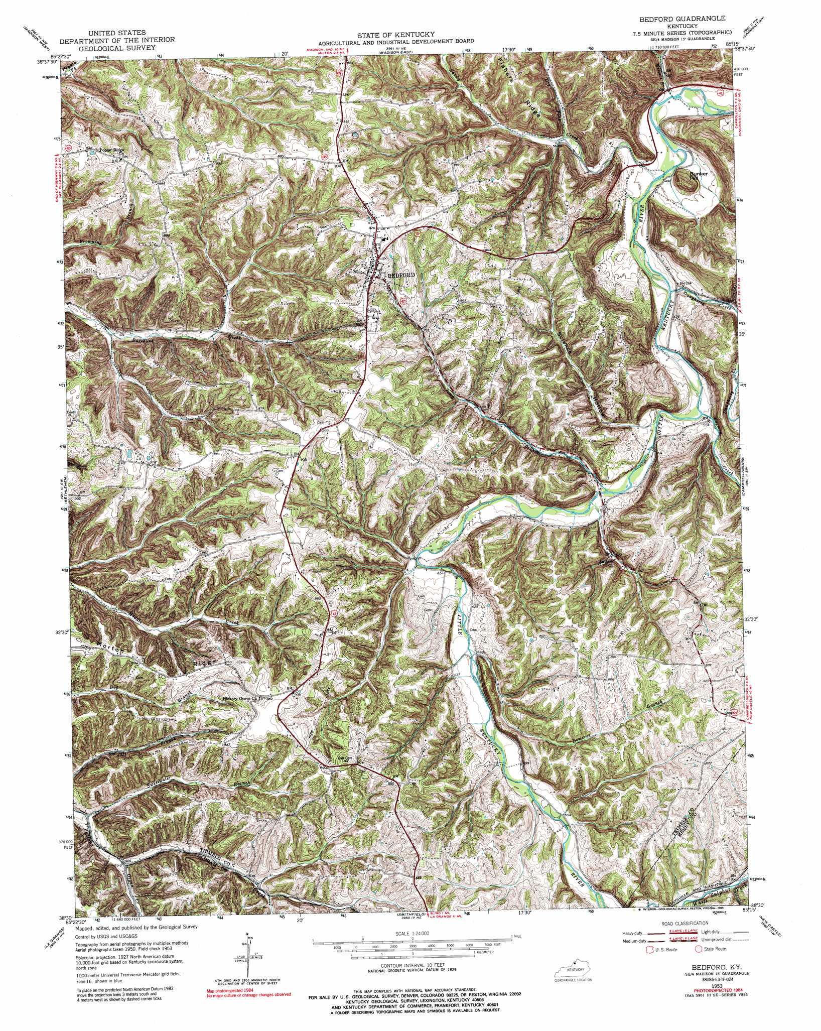
USGS Topo Quad 38085e3 - 1:24,000 scale
| Topo Map Name: | Bedford |
| USGS Topo Quad ID: | 38085e3 |
| Print Size: | ca. 21 1/4" wide x 27" high |
| Southeast Coordinates: | 38.5° N latitude / 85.25° W longitude |
| Map Center Coordinates: | 38.5625° N latitude / 85.3125° W longitude |
| U.S. State: | KY |
| Filename: | o38085e3.jpg |
| Download Map JPG Image: | Bedford topo map 1:24,000 scale |
| Map Type: | Topographic |
| Topo Series: | 7.5´ |
| Map Scale: | 1:24,000 |
| Source of Map Images: | United States Geological Survey (USGS) |
| Alternate Map Versions: |
Bedford KY 1953, updated 1954 Download PDF Buy paper map Bedford KY 1953, updated 1972 Download PDF Buy paper map Bedford KY 1953, updated 1989 Download PDF Buy paper map Bedford KY 2010 Download PDF Buy paper map Bedford KY 2013 Download PDF Buy paper map Bedford KY 2016 Download PDF Buy paper map |
1:24,000 Topo Quads surrounding Bedford
Volga |
Clifty Falls |
Canaan |
Bennington |
Vevay North |
Kent |
Madison West |
Madison East |
Carrollton |
Vevay South |
New Washington |
Bethlehem |
Bedford |
Campbellsburg |
Worthville |
Owen |
La Grange |
Smithfield |
New Castle |
Franklinton |
Anchorage |
Crestwood |
Ballardsville |
Eminence |
North Pleasureville |
> Back to 38085e1 at 1:100,000 scale
> Back to 38084a1 at 1:250,000 scale
> Back to U.S. Topo Maps home
Bedford topo map: Gazetteer
Bedford: Populated Places
Bedford elevation 275m 902′Bedford: Ridges
Morton Ridge elevation 249m 816′Bedford: Streams
Carmon Creek elevation 162m 531′Daugherty Creek elevation 155m 508′
Demeree Branch elevation 188m 616′
Dry Fork elevation 170m 557′
Hardy Creek elevation 148m 485′
Middle Fork Blue River elevation 244m 800′
Millers Branch elevation 144m 472′
Organ Creek elevation 170m 557′
Sweetwater Branch elevation 159m 521′
Town Branch elevation 170m 557′
Bedford: Summits
Bunker Hill elevation 206m 675′Bedford: Valleys
Science Hollow elevation 173m 567′Bedford digital topo map on disk
Buy this Bedford topo map showing relief, roads, GPS coordinates and other geographical features, as a high-resolution digital map file on DVD: