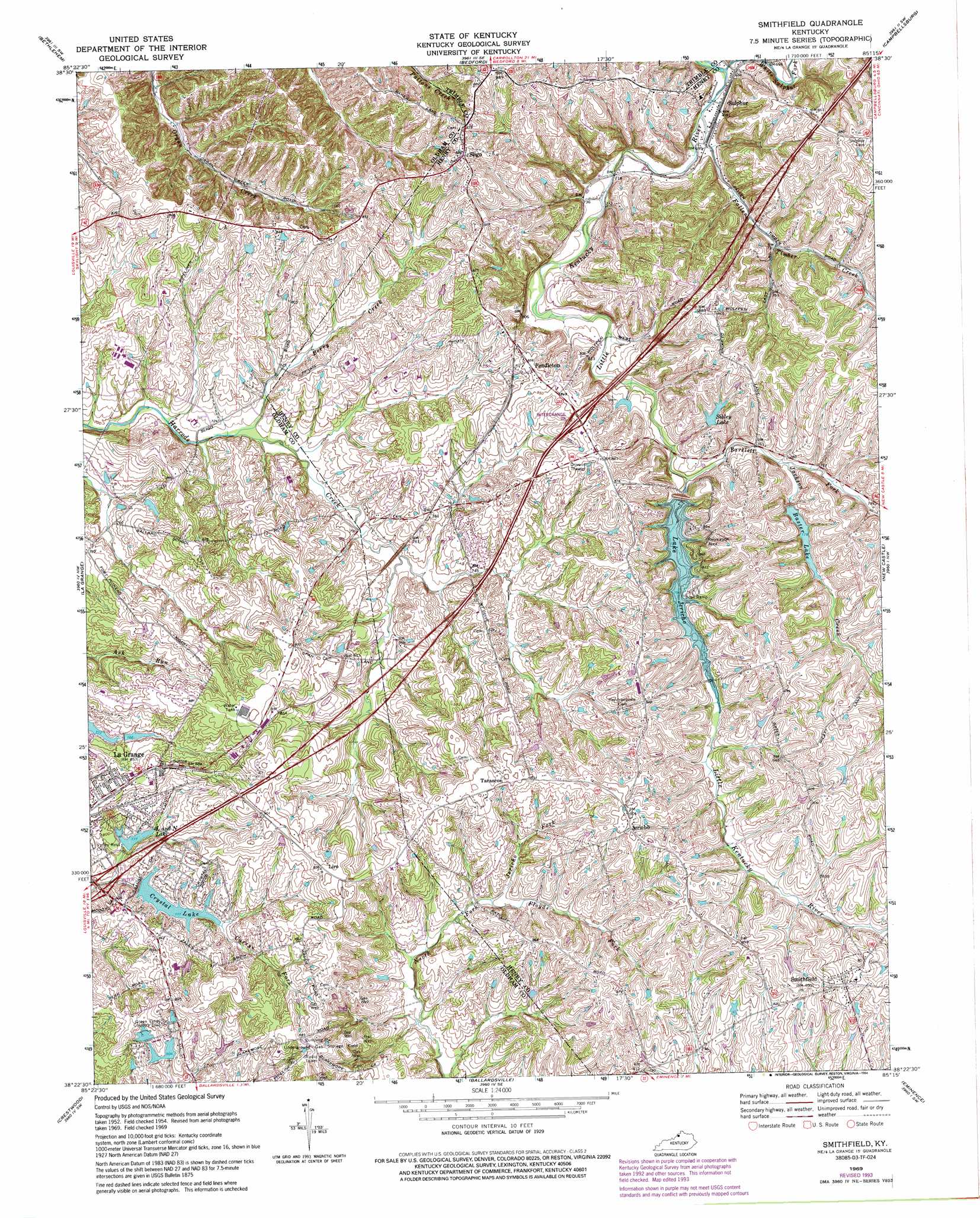
Smithfield Topo Map Kentucky
To zoom in, hover over the map of Smithfield
USGS Topo Quad 38085d3 - 1:24,000 scale
| Topo Map Name: | Smithfield |
| USGS Topo Quad ID: | 38085d3 |
| Print Size: | ca. 21 1/4" wide x 27" high |
| Southeast Coordinates: | 38.375° N latitude / 85.25° W longitude |
| Map Center Coordinates: | 38.4375° N latitude / 85.3125° W longitude |
| U.S. State: | KY |
| Filename: | o38085d3.jpg |
| Download Map JPG Image: | Smithfield topo map 1:24,000 scale |
| Map Type: | Topographic |
| Topo Series: | 7.5´ |
| Map Scale: | 1:24,000 |
| Source of Map Images: | United States Geological Survey (USGS) |
| Alternate Map Versions: |
Smithfield KY 1954, updated 1955 Download PDF Buy paper map Smithfield KY 1961, updated 1962 Download PDF Buy paper map Smithfield KY 1969, updated 1971 Download PDF Buy paper map Smithfield KY 1969, updated 1972 Download PDF Buy paper map Smithfield KY 1969, updated 1979 Download PDF Buy paper map Smithfield KY 1969, updated 1987 Download PDF Buy paper map Smithfield KY 1969, updated 1994 Download PDF Buy paper map Smithfield KY 2010 Download PDF Buy paper map Smithfield KY 2013 Download PDF Buy paper map Smithfield KY 2016 Download PDF Buy paper map |
1:24,000 Topo Quads surrounding Smithfield
Kent |
Madison West |
Madison East |
Carrollton |
Vevay South |
New Washington |
Bethlehem |
Bedford |
Campbellsburg |
Worthville |
Owen |
La Grange |
Smithfield |
New Castle |
Franklinton |
Anchorage |
Crestwood |
Ballardsville |
Eminence |
North Pleasureville |
Jeffersontown |
Fisherville |
Simpsonville |
Shelbyville |
Waddy |
> Back to 38085a1 at 1:100,000 scale
> Back to 38084a1 at 1:250,000 scale
> Back to U.S. Topo Maps home
Smithfield topo map: Gazetteer
Smithfield: Populated Places
Jericho elevation 274m 898′Liro elevation 272m 892′
Pendleton elevation 261m 856′
Sligo elevation 268m 879′
Smithfield elevation 267m 875′
Sulphur elevation 210m 688′
Tarascon elevation 274m 898′
Smithfield: Post Offices
Jericho Post Office (historical) elevation 272m 892′Sligo Post Office (historical) elevation 271m 889′
Smithfield: Reservoirs
Baxter Lake elevation 244m 800′Crystal Lake elevation 237m 777′
L and N Lake elevation 236m 774′
Lake Jericho elevation 238m 780′
Sibley Lake elevation 244m 800′
Smithfield: Streams
Bartlett Fork elevation 226m 741′Berry Creek elevation 216m 708′
Fallen Timber Creek elevation 208m 682′
Jackson Creek elevation 231m 757′
Jericho Fork elevation 234m 767′
White Sulphur Fork elevation 205m 672′
Smithfield digital topo map on disk
Buy this Smithfield topo map showing relief, roads, GPS coordinates and other geographical features, as a high-resolution digital map file on DVD: