Houston Gulch Topo Map Colorado
To zoom in, hover over the map of Houston Gulch
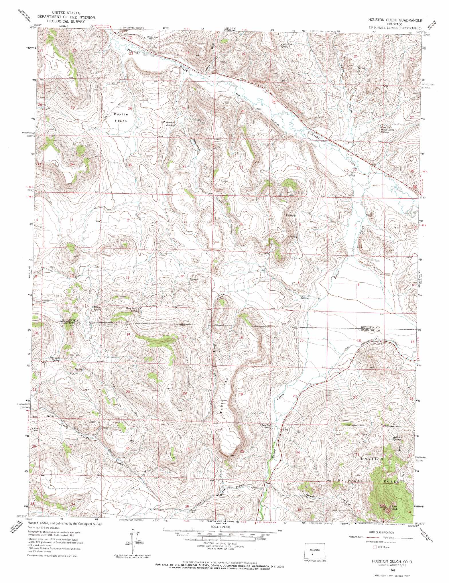
USGS Topo Quad 38106d6 - 1:24,000 scale
| Topo Map Name: | Houston Gulch |
| USGS Topo Quad ID: | 38106d6 |
| Print Size: | ca. 21 1/4" wide x 27" high |
| Southeast Coordinates: | 38.375° N latitude / 106.625° W longitude |
| Map Center Coordinates: | 38.4375° N latitude / 106.6875° W longitude |
| U.S. State: | CO |
| Filename: | o38106d6.jpg |
| Download Map JPG Image: | Houston Gulch topo map 1:24,000 scale |
| Map Type: | Topographic |
| Topo Series: | 7.5´ |
| Map Scale: | 1:24,000 |
| Source of Map Images: | United States Geological Survey (USGS) |
| Alternate Map Versions: |
Houston Gulch CO 1962, updated 1964 Download PDF Buy paper map Houston Gulch CO 1962, updated 1972 Download PDF Buy paper map Houston Gulch CO 2001, updated 2004 Download PDF Buy paper map Houston Gulch CO 2011 Download PDF Buy paper map Houston Gulch CO 2013 Download PDF Buy paper map Houston Gulch CO 2016 Download PDF Buy paper map |
| FStopo: | US Forest Service topo Houston Gulch is available: Download FStopo PDF Download FStopo TIF |
1:24,000 Topo Quads surrounding Houston Gulch
Flat Top |
Almont |
Crystal Creek |
Fairview Peak |
Cumberland Pass |
Gunnison |
Signal Peak |
Parlin |
Pitkin |
Whitepine |
Iris Nw |
Iris |
Houston Gulch |
Doyleville |
Sargents |
Spring Hill Creek |
Sawtooth Mountain |
Razor Creek Dome |
West Baldy |
Sargents Mesa |
Rock Creek Park |
Cold Spring Park |
Cochetopa Park |
North Pass |
Trickle Mountain |
> Back to 38106a1 at 1:100,000 scale
> Back to 38106a1 at 1:250,000 scale
> Back to U.S. Topo Maps home
Houston Gulch topo map: Gazetteer
Houston Gulch: Flats
Parlin Flats elevation 2464m 8083′Houston Gulch: Mines
Alaska Mine elevation 2575m 8448′Friendly Neighbor Mine elevation 2604m 8543′
Sage Hen Mine elevation 2604m 8543′
Houston Gulch: Springs
East Parlin Spring elevation 2628m 8622′East Side Wood Gulch Spring elevation 2468m 8097′
Kilborn Spring elevation 2700m 8858′
Powertime Spring elevation 2578m 8458′
Prospector Spring elevation 2443m 8015′
Sage Hen Spring elevation 2569m 8428′
Valdez Spring elevation 2586m 8484′
Houston Gulch: Streams
Lemay Wash elevation 2425m 7956′Razor Creek elevation 2440m 8005′
Houston Gulch: Summits
Lions Head elevation 3120m 10236′Table Top elevation 2757m 9045′
Houston Gulch: Valleys
Houston Gulch elevation 2425m 7956′Long Gulch elevation 2476m 8123′
Poverty Gulch elevation 2555m 8382′
Snyder Gulch elevation 2550m 8366′
Wood Gulch elevation 2440m 8005′
Houston Gulch digital topo map on disk
Buy this Houston Gulch topo map showing relief, roads, GPS coordinates and other geographical features, as a high-resolution digital map file on DVD: