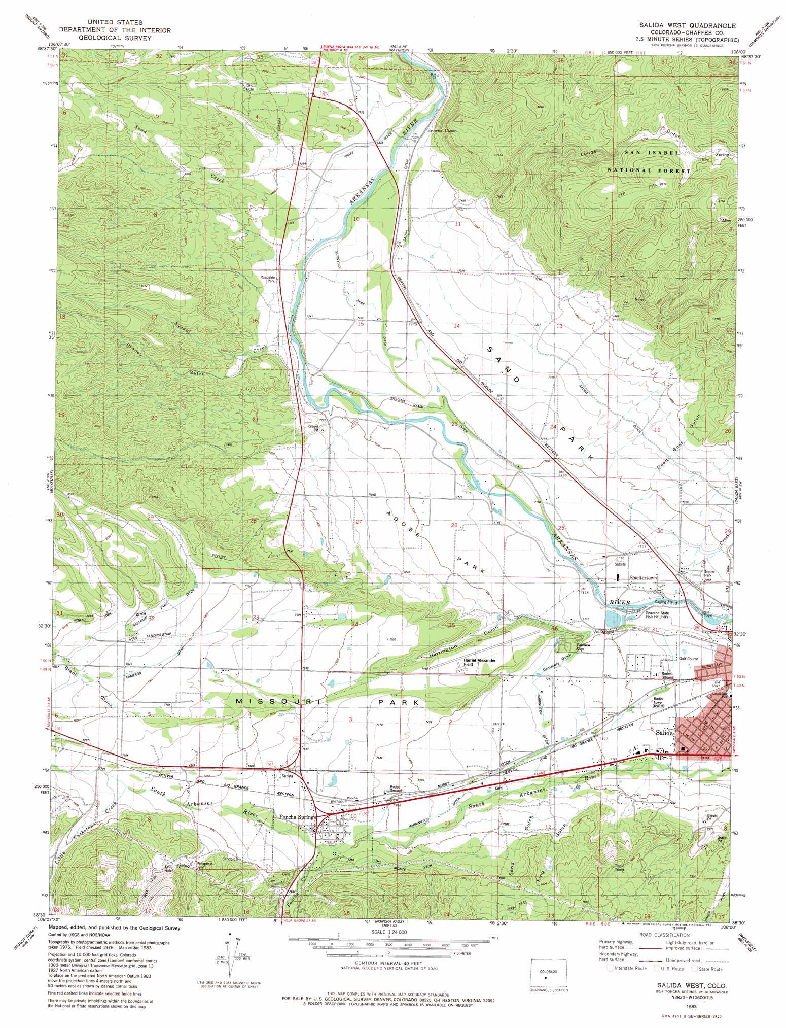
Salida West Topo Map Colorado
To zoom in, hover over the map of Salida West
USGS Topo Quad 38106e1 - 1:24,000 scale
| Topo Map Name: | Salida West |
| USGS Topo Quad ID: | 38106e1 |
| Print Size: | ca. 21 1/4" wide x 27" high |
| Southeast Coordinates: | 38.5° N latitude / 106° W longitude |
| Map Center Coordinates: | 38.5625° N latitude / 106.0625° W longitude |
| U.S. State: | CO |
| Filename: | o38106e1.jpg |
| Download Map JPG Image: | Salida West topo map 1:24,000 scale |
| Map Type: | Topographic |
| Topo Series: | 7.5´ |
| Map Scale: | 1:24,000 |
| Source of Map Images: | United States Geological Survey (USGS) |
| Alternate Map Versions: |
Salida West CO 1983, updated 1983 Download PDF Buy paper map Salida West CO 1983, updated 1983 Download PDF Buy paper map Salida West CO 1994, updated 1998 Download PDF Buy paper map Salida West CO 2011 Download PDF Buy paper map Salida West CO 2013 Download PDF Buy paper map Salida West CO 2016 Download PDF Buy paper map |
| FStopo: | US Forest Service topo Salida West is available: Download FStopo PDF Download FStopo TIF |
1:24,000 Topo Quads surrounding Salida West
Mount Yale |
Buena Vista West |
Buena Vista East |
Castle Rock Gulch |
Agate Mountain |
Saint Elmo |
Mount Antero |
Nathrop |
Cameron Mountain |
Gribbles Park |
Garfield |
Maysville |
Salida West |
Salida East |
Jack Hall Mountain |
Pahlone Peak |
Mount Ouray |
Poncha Pass |
Wellsville |
Howard |
Chester |
Bonanza |
Whale Hill |
Bushnell Peak |
Coaldale |
> Back to 38106e1 at 1:100,000 scale
> Back to 38106a1 at 1:250,000 scale
> Back to U.S. Topo Maps home
Salida West topo map: Gazetteer
Salida West: Airports
CMRS Airdrome Airport elevation 2390m 7841′Harriet Alexander Field elevation 2270m 7447′
Salida Airport elevation 2274m 7460′
Salida West: Canals
Harrington Ditch elevation 2232m 7322′Kraft Ditch elevation 2234m 7329′
Missouri Park Ditch elevation 2233m 7326′
Salida Ditch elevation 2224m 7296′
Sunnyside Park Ditch elevation 2239m 7345′
Williams-Hamm Ditch elevation 2183m 7162′
Salida West: Dams
Franz Number 1 Dam elevation 2167m 7109′Salida West: Flats
Adobe Park elevation 2197m 7208′Missouri Park elevation 2314m 7591′
Sand Park elevation 2216m 7270′
Salida West: Mines
Aksarben Mine elevation 2164m 7099′Ben Hill Mine elevation 2489m 8166′
Bonus Extension Mine elevation 2674m 8772′
Bowen Quarry elevation 2164m 7099′
Colorado Granite Quarry elevation 2164m 7099′
Condor Mine elevation 2521m 8270′
Delay Tunnel Mine elevation 2164m 7099′
Federal Quarry elevation 2164m 7099′
Jack Rabbit Group Mine elevation 2521m 8270′
Mount Cross Granite Quarry elevation 2164m 7099′
Mount Princeton Quarry elevation 2164m 7099′
Polly Number Four Mine elevation 2164m 7099′
Rose Pink Quarry elevation 2164m 7099′
Sedalia Mine elevation 2547m 8356′
Stewart Mine elevation 2164m 7099′
Ulrich Pit elevation 2164m 7099′
Warner Granite Quarry elevation 2164m 7099′
Wonder Lode Mine elevation 2521m 8270′
Salida West: Populated Places
Belleview elevation 2201m 7221′Browns Canon elevation 2231m 7319′
Poncha Springs elevation 2275m 7463′
Smeltertown elevation 2159m 7083′
Salida West: Post Offices
Poncha Springs Post Office elevation 2278m 7473′Salida West: Reservoirs
Franz Number 1 Reservoir elevation 2167m 7109′Salida West: Streams
Del Monte Ditch elevation 2301m 7549′Little Cochetopa Creek elevation 2334m 7657′
Murry Ditch elevation 2191m 7188′
Poncha Creek elevation 2269m 7444′
Sand Creek elevation 2211m 7253′
Ute Creek elevation 2148m 7047′
Williams Hamm Ditch elevation 2181m 7155′
Salida West: Valleys
Browns Canyon elevation 2218m 7276′Cedar Gulch elevation 2438m 7998′
Cemetery Gulch elevation 2186m 7171′
Dead Goat Gulch elevation 2195m 7201′
Droney Gulch elevation 2244m 7362′
Harrington Gulch elevation 2179m 7148′
King Gulch elevation 2221m 7286′
Longs Gulch elevation 2260m 7414′
Sand Gulch elevation 2222m 7290′
Salida West digital topo map on disk
Buy this Salida West topo map showing relief, roads, GPS coordinates and other geographical features, as a high-resolution digital map file on DVD: