Jack Hall Mountain Topo Map Colorado
To zoom in, hover over the map of Jack Hall Mountain
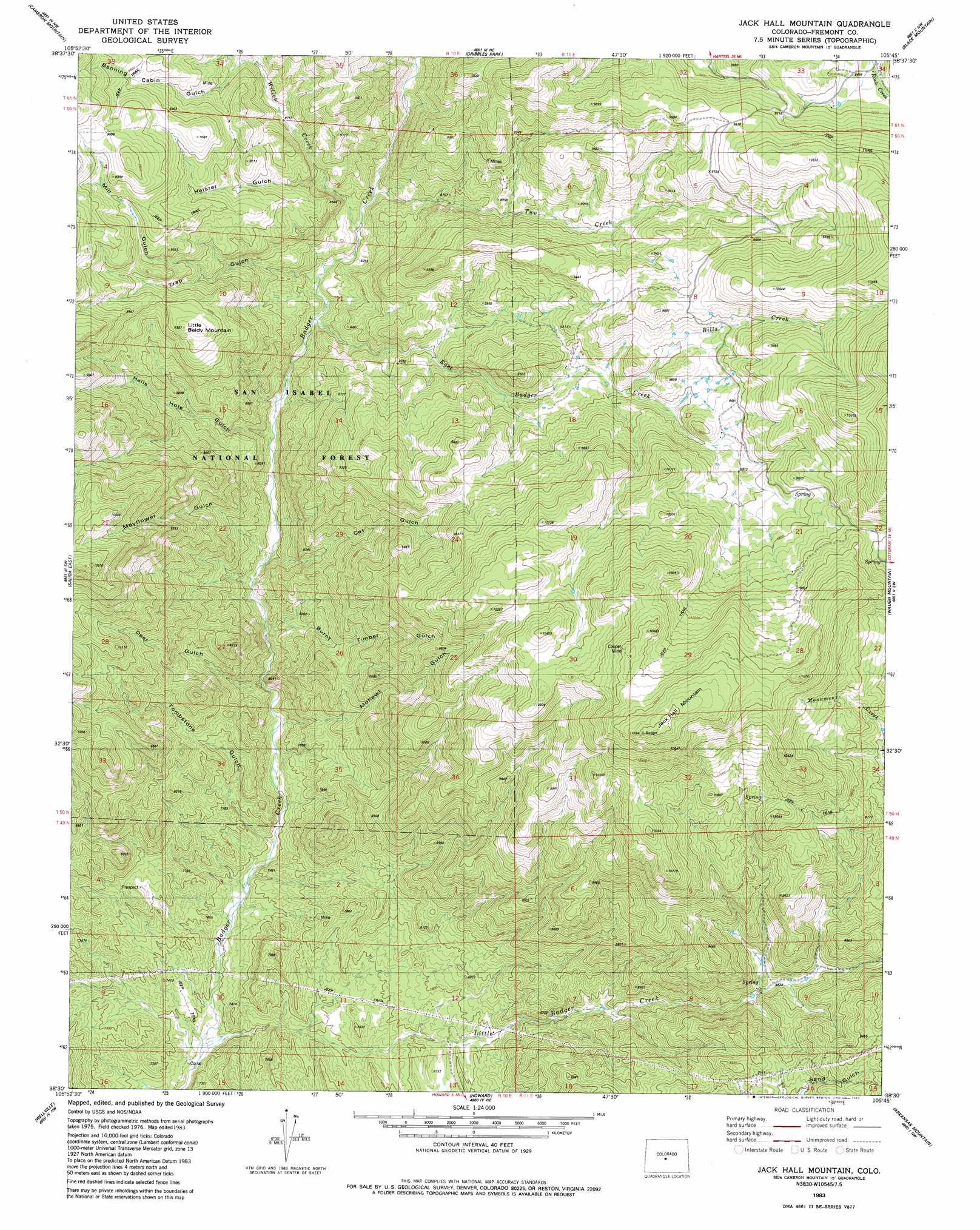
USGS Topo Quad 38105e7 - 1:24,000 scale
| Topo Map Name: | Jack Hall Mountain |
| USGS Topo Quad ID: | 38105e7 |
| Print Size: | ca. 21 1/4" wide x 27" high |
| Southeast Coordinates: | 38.5° N latitude / 105.75° W longitude |
| Map Center Coordinates: | 38.5625° N latitude / 105.8125° W longitude |
| U.S. State: | CO |
| Filename: | o38105e7.jpg |
| Download Map JPG Image: | Jack Hall Mountain topo map 1:24,000 scale |
| Map Type: | Topographic |
| Topo Series: | 7.5´ |
| Map Scale: | 1:24,000 |
| Source of Map Images: | United States Geological Survey (USGS) |
| Alternate Map Versions: |
Jack Hall Mountain CO 1983, updated 1983 Download PDF Buy paper map Jack Hall Mountain CO 1983, updated 1983 Download PDF Buy paper map Jack Hall Mountain CO 1994, updated 1998 Download PDF Buy paper map Jack Hall Mountain CO 2011 Download PDF Buy paper map Jack Hall Mountain CO 2013 Download PDF Buy paper map Jack Hall Mountain CO 2016 Download PDF Buy paper map |
| FStopo: | US Forest Service topo Jack Hall Mountain is available: Download FStopo PDF Download FStopo TIF |
1:24,000 Topo Quads surrounding Jack Hall Mountain
Buena Vista East |
Castle Rock Gulch |
Agate Mountain |
Dicks Peak |
Thirtynine Mile Mountain |
Nathrop |
Cameron Mountain |
Gribbles Park |
Black Mountain |
Thirtyone Mile Mountain |
Salida West |
Salida East |
Jack Hall Mountain |
Waugh Mountain |
Hall Gulch |
Poncha Pass |
Wellsville |
Howard |
Arkansas Mountain |
Echo |
Whale Hill |
Bushnell Peak |
Coaldale |
Cotopaxi |
Hillside |
> Back to 38105e1 at 1:100,000 scale
> Back to 38104a1 at 1:250,000 scale
> Back to U.S. Topo Maps home
Jack Hall Mountain topo map: Gazetteer
Jack Hall Mountain: Mines
Badger Creek Mine elevation 2495m 8185′Cooper Mine elevation 3247m 10652′
Maverick Gulch Mine elevation 2542m 8339′
Whispering Pine Mine elevation 2238m 7342′
Jack Hall Mountain: Streams
Bills Creek elevation 2802m 9192′East Badger Creek elevation 2449m 8034′
Little Badger Creek elevation 2161m 7089′
Two Creek elevation 2513m 8244′
Willow Creek elevation 2501m 8205′
Jack Hall Mountain: Summits
Jack Hall Mountain elevation 3345m 10974′Little Baldy Mountain elevation 2860m 9383′
Jack Hall Mountain: Valleys
Banning Cabin Gulch elevation 2688m 8818′Burnt Timber Gulch elevation 2348m 7703′
Cat Gulch elevation 2374m 7788′
Heister Gulch elevation 2585m 8480′
Hells Hole Gulch elevation 2433m 7982′
Mayflower Gulch elevation 2356m 7729′
Mill Gulch elevation 2681m 8795′
Mohawk Gulch elevation 2295m 7529′
Tombstone Gulch elevation 2251m 7385′
Trap Gulch elevation 2475m 8120′
Jack Hall Mountain digital topo map on disk
Buy this Jack Hall Mountain topo map showing relief, roads, GPS coordinates and other geographical features, as a high-resolution digital map file on DVD: