Mason-Dixon Topo Map Maryland
To zoom in, hover over the map of Mason-Dixon
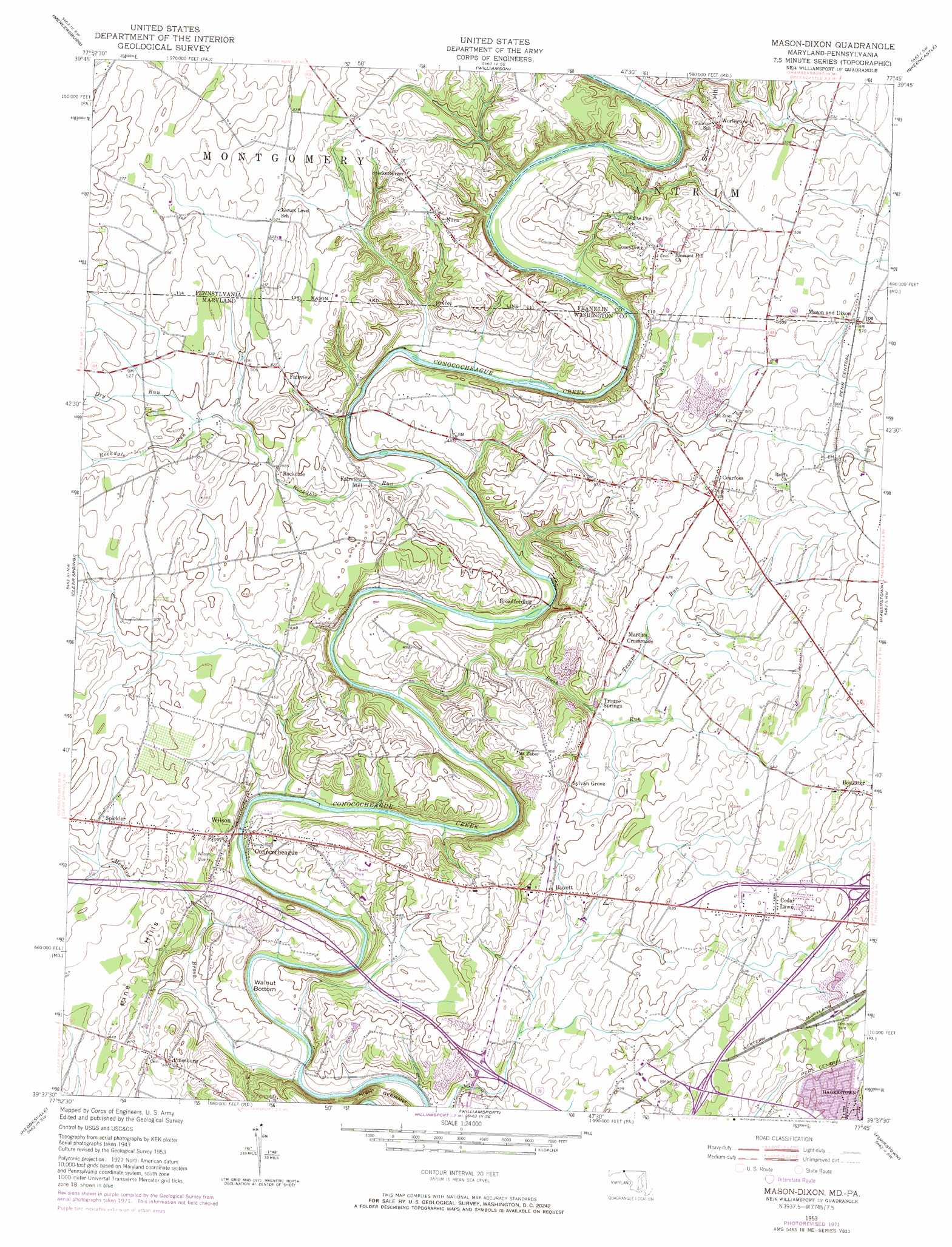
USGS Topo Quad 39077f7 - 1:24,000 scale
| Topo Map Name: | Mason-Dixon |
| USGS Topo Quad ID: | 39077f7 |
| Print Size: | ca. 21 1/4" wide x 27" high |
| Southeast Coordinates: | 39.625° N latitude / 77.75° W longitude |
| Map Center Coordinates: | 39.6875° N latitude / 77.8125° W longitude |
| U.S. States: | MD, PA |
| Filename: | o39077f7.jpg |
| Download Map JPG Image: | Mason-Dixon topo map 1:24,000 scale |
| Map Type: | Topographic |
| Topo Series: | 7.5´ |
| Map Scale: | 1:24,000 |
| Source of Map Images: | United States Geological Survey (USGS) |
| Alternate Map Versions: |
Mason-Dixon PA 1944 Download PDF Buy paper map Mason-Dixon PA 1953, updated 1954 Download PDF Buy paper map Mason-Dixon PA 1953, updated 1954 Download PDF Buy paper map Mason-Dixon PA 1953, updated 1966 Download PDF Buy paper map Mason-Dixon PA 1953, updated 1972 Download PDF Buy paper map Mason and Dixon PA 2011 Download PDF Buy paper map Mason and Dixon PA 2013 Download PDF Buy paper map Mason and Dixon PA 2016 Download PDF Buy paper map |
1:24,000 Topo Quads surrounding Mason-Dixon
Meadow Grounds |
Mcconnellsburg |
Saint Thomas |
Chambersburg |
Scotland |
Big Cove Tannery |
Mercersburg |
Williamson |
Greencastle |
Waynesboro |
Cherry Run |
Clear Spring |
Mason-Dixon |
Hagerstown |
Smithsburg |
Big Pool |
Hedgesville |
Williamsport |
Funkstown |
Myersville |
Tablers Station |
Martinsburg |
Shepherdstown |
Keedysville |
Middletown |
> Back to 39077e1 at 1:100,000 scale
> Back to 39076a1 at 1:250,000 scale
> Back to U.S. Topo Maps home
Mason-Dixon topo map: Gazetteer
Mason-Dixon: Bends
High Germany elevation 127m 416′Walnut Bottom elevation 120m 393′
Mason-Dixon: Bridges
Wilson Bridge elevation 108m 354′Mason-Dixon: Crossings
Interchange 24 elevation 125m 410′Interchange 6 elevation 171m 561′
Mason-Dixon: Mines
Wilson Quarry elevation 131m 429′Mason-Dixon: Parks
Piper Lane Neighborhood Park elevation 182m 597′Mason-Dixon: Populated Places
Arboranda Estates elevation 144m 472′Bostetter elevation 186m 610′
Broadfording elevation 121m 396′
Cearfoss elevation 156m 511′
Cedar Lawn elevation 168m 551′
Conococheague elevation 128m 419′
Coseytown elevation 175m 574′
Deer Lodge Mobile Home Park elevation 135m 442′
Fairview elevation 151m 495′
Fairview Acres elevation 164m 538′
Fairview Mill elevation 136m 446′
Gardenspot elevation 183m 600′
Greenberry Hills elevation 189m 620′
Gristmill Hill elevation 140m 459′
Huyett elevation 146m 479′
Kent Estates elevation 164m 538′
Martins Crossroads elevation 145m 475′
Mason and Dixon elevation 172m 564′
Nova elevation 168m 551′
Oaklett Estates elevation 135m 442′
Pinesburg elevation 152m 498′
Rockdale elevation 145m 475′
Spickler elevation 146m 479′
Spring Hill Estates elevation 176m 577′
Sylvan Grove elevation 155m 508′
Troupe Springs elevation 134m 439′
Wilson elevation 117m 383′
Worleytown elevation 175m 574′
Mason-Dixon: Ranges
Pine Hills elevation 134m 439′Mason-Dixon: Springs
Troupe Springs elevation 135m 442′Mason-Dixon: Streams
Dry Run elevation 150m 492′Meadow Brook elevation 105m 344′
Rockdale Run elevation 119m 390′
Rush Run elevation 112m 367′
Toms Run elevation 122m 400′
Troupe Run elevation 132m 433′
Mason-Dixon: Summits
Scar Hill elevation 175m 574′Mason-Dixon digital topo map on disk
Buy this Mason-Dixon topo map showing relief, roads, GPS coordinates and other geographical features, as a high-resolution digital map file on DVD:
Atlantic Coast (NY, NJ, PA, DE, MD, VA, NC)
Buy digital topo maps: Atlantic Coast (NY, NJ, PA, DE, MD, VA, NC)
 map DVD")