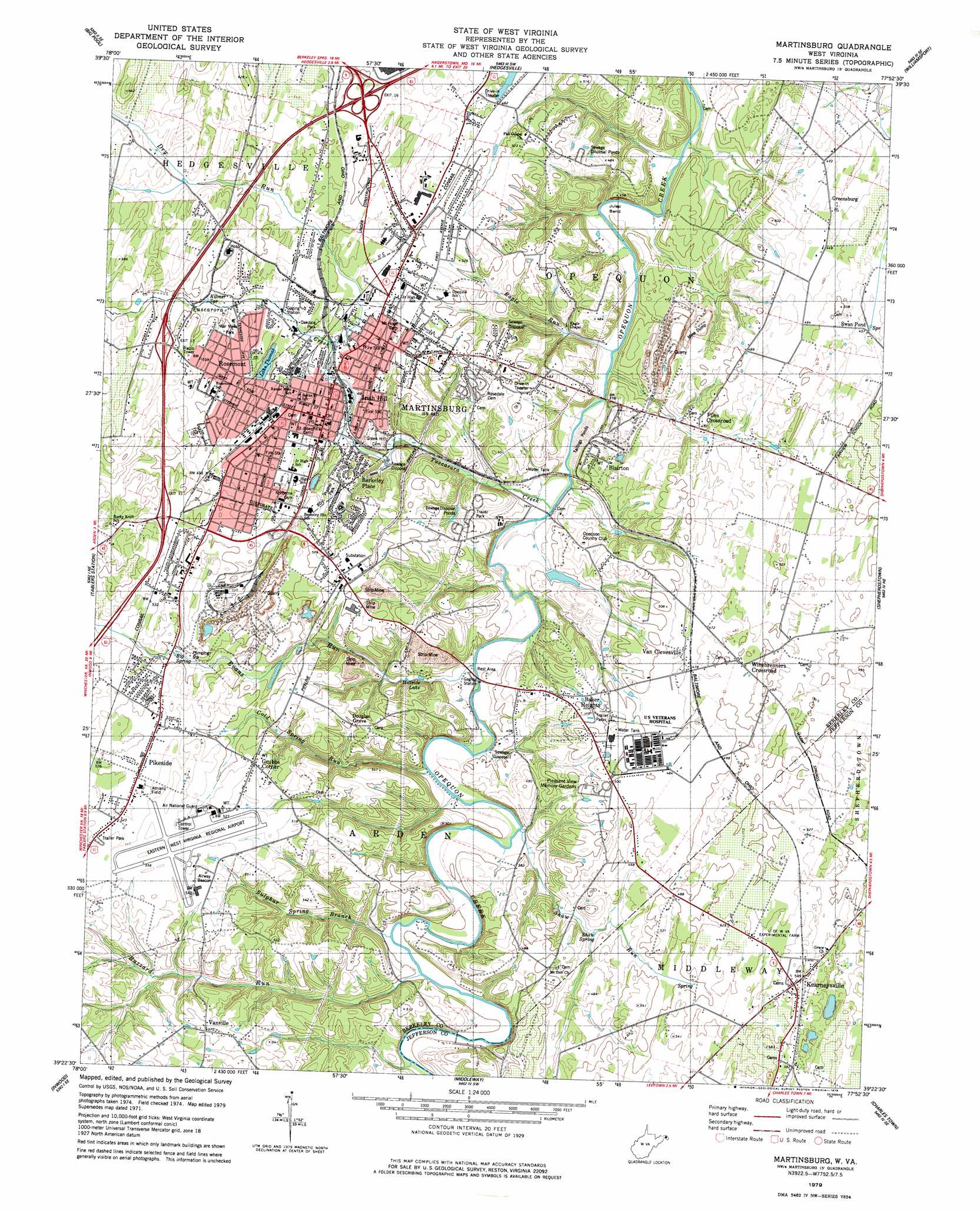
Martinsburg Topo Map West Virginia
To zoom in, hover over the map of Martinsburg
USGS Topo Quad 39077d8 - 1:24,000 scale
| Topo Map Name: | Martinsburg |
| USGS Topo Quad ID: | 39077d8 |
| Print Size: | ca. 21 1/4" wide x 27" high |
| Southeast Coordinates: | 39.375° N latitude / 77.875° W longitude |
| Map Center Coordinates: | 39.4375° N latitude / 77.9375° W longitude |
| U.S. State: | WV |
| Filename: | o39077d8.jpg |
| Download Map JPG Image: | Martinsburg topo map 1:24,000 scale |
| Map Type: | Topographic |
| Topo Series: | 7.5´ |
| Map Scale: | 1:24,000 |
| Source of Map Images: | United States Geological Survey (USGS) |
| Alternate Map Versions: |
Martinsburg WV 1955, updated 1957 Download PDF Buy paper map Martinsburg WV 1955, updated 1972 Download PDF Buy paper map Martinsburg WV 1979, updated 1979 Download PDF Buy paper map Martinsburg WV 1997, updated 2000 Download PDF Buy paper map Martinsburg WV 2010 Download PDF Buy paper map Martinsburg WV 2014 Download PDF Buy paper map Martinsburg WV 2016 Download PDF Buy paper map |
1:24,000 Topo Quads surrounding Martinsburg
Hancock |
Cherry Run |
Clear Spring |
Mason-Dixon |
Hagerstown |
Stotlers Crossroads |
Big Pool |
Hedgesville |
Williamsport |
Funkstown |
Glengary |
Tablers Station |
Martinsburg |
Shepherdstown |
Keedysville |
White Hall |
Inwood |
Middleway |
Charles Town |
Harpers Ferry |
Winchester |
Stephenson |
Berryville |
Round Hill |
Purcellville |
> Back to 39077a1 at 1:100,000 scale
> Back to 39076a1 at 1:250,000 scale
> Back to U.S. Topo Maps home
Martinsburg topo map: Gazetteer
Martinsburg: Airports
City Hospital Incorporated Heliport elevation 165m 541′Eastern West Virginia Regional Airport elevation 165m 541′
Veterans Affairs Medical Center Heliport elevation 151m 495′
Martinsburg: Bends
Julep Bend elevation 107m 351′Martinsburg: Bridges
Van Metre Ford Stone Bridge elevation 107m 351′Martinsburg: Crossings
Exit 12 elevation 159m 521′Exit 13 elevation 155m 508′
Exit 16 elevation 146m 479′
Paynes Ford elevation 120m 393′
Martinsburg: Lakes
Hillside Lake elevation 116m 380′Lake Thomas elevation 135m 442′
Swan Pond elevation 136m 446′
Martinsburg: Parks
Baltimore and Ohio and Related Industries Historic District elevation 144m 472′Boomtown Historic District elevation 134m 439′
Boydville Historic District elevation 141m 462′
Charlotte Prather Park elevation 145m 475′
Downtown Martinsburg Historic District elevation 138m 452′
East Martinsburg Historic District elevation 129m 423′
Green Hill Cemetery Historic District elevation 137m 449′
Oatesdale Park elevation 137m 449′
Prather Park elevation 136m 446′
South Water Street Historic District elevation 129m 423′
Swan Pond Manor Historic District elevation 139m 456′
Tuscarora Creek Historic District elevation 144m 472′
War Memorial Park elevation 153m 501′
Martinsburg: Populated Places
Adam Stephen Homes elevation 142m 465′Baker Heights elevation 139m 456′
Berkeley Place elevation 143m 469′
Blairton elevation 131m 429′
Boydville elevation 141m 462′
Douglas Grove elevation 153m 501′
Files Crossroad elevation 137m 449′
Greensburg elevation 135m 442′
Grubbs Corner elevation 165m 541′
Irish Hill elevation 141m 462′
Kearneysville elevation 168m 551′
Martinsburg elevation 138m 452′
Pikeside elevation 157m 515′
Rosemont elevation 151m 495′
Swan Pond elevation 139m 456′
Van Clevesville elevation 143m 469′
Vanville elevation 173m 567′
Winebrenners Crossroad elevation 149m 488′
Martinsburg: Post Offices
Kearneysville Post Office elevation 172m 564′Martinsburg Post Office elevation 136m 446′
Martinsburg: Ridges
Seigert Heights elevation 147m 482′Martinsburg: Springs
Big Spring elevation 148m 485′Blairton Spring elevation 110m 360′
Couchman Springs elevation 135m 442′
Dailey Spring elevation 145m 475′
General Horace Gates Farm Spring elevation 152m 498′
Kilmer Spring elevation 147m 482′
Martinsburg Water Supply Spring elevation 135m 442′
Shade Spring elevation 158m 518′
Shaw Spring elevation 127m 416′
Swan Pond Spring elevation 137m 449′
Van Meter Spring elevation 124m 406′
Martinsburg: Streams
Buzzard Run elevation 115m 377′Cold Spring Run elevation 113m 370′
Dry Run elevation 132m 433′
Eagle Run elevation 106m 347′
Evans Run elevation 109m 357′
Shaw Run elevation 115m 377′
Sulphur Spring Branch elevation 114m 374′
Tuscarora Creek elevation 108m 354′
Martinsburg digital topo map on disk
Buy this Martinsburg topo map showing relief, roads, GPS coordinates and other geographical features, as a high-resolution digital map file on DVD:
Atlantic Coast (NY, NJ, PA, DE, MD, VA, NC)
Buy digital topo maps: Atlantic Coast (NY, NJ, PA, DE, MD, VA, NC)
 map DVD")