Ferron Canyon Topo Map Utah
To zoom in, hover over the map of Ferron Canyon
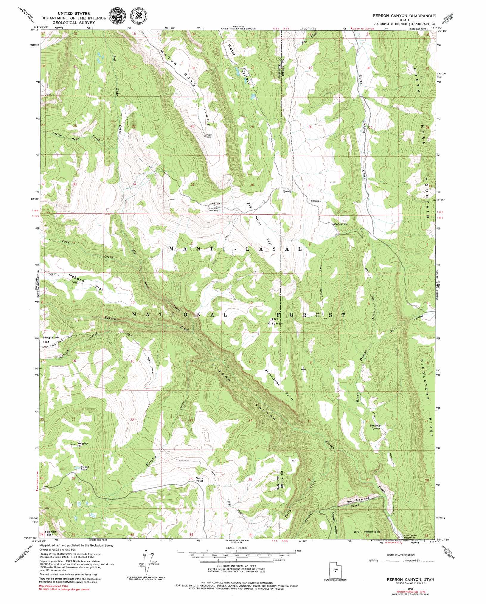
USGS Topo Quad 39111b3 - 1:24,000 scale
| Topo Map Name: | Ferron Canyon |
| USGS Topo Quad ID: | 39111b3 |
| Print Size: | ca. 21 1/4" wide x 27" high |
| Southeast Coordinates: | 39.125° N latitude / 111.25° W longitude |
| Map Center Coordinates: | 39.1875° N latitude / 111.3125° W longitude |
| U.S. State: | UT |
| Filename: | o39111b3.jpg |
| Download Map JPG Image: | Ferron Canyon topo map 1:24,000 scale |
| Map Type: | Topographic |
| Topo Series: | 7.5´ |
| Map Scale: | 1:24,000 |
| Source of Map Images: | United States Geological Survey (USGS) |
| Alternate Map Versions: |
Ferron Canyon UT 1966, updated 1968 Download PDF Buy paper map Ferron Canyon UT 2001, updated 2004 Download PDF Buy paper map Ferron Canyon UT 2011 Download PDF Buy paper map Ferron Canyon UT 2014 Download PDF Buy paper map |
| FStopo: | US Forest Service topo Ferron Canyon is available: Download FStopo PDF Download FStopo TIF |
1:24,000 Topo Quads surrounding Ferron Canyon
Chester |
Spring City |
South Tent Mountain |
Rilda Canyon |
Hiawatha |
Ephraim |
Danish Knoll |
Joes Valley Reservoir |
Mahogany Point |
Red Point |
Black Mountain |
Ferron Reservoir |
Ferron Canyon |
The Cap |
Castle Dale |
Woods Lake |
Heliotrope Mountain |
Flagstaff Peak |
Ferron |
Molen |
Water Hollow Ridge |
Acord Lakes |
Emery West |
Emery East |
Short Canyon |
> Back to 39111a1 at 1:100,000 scale
> Back to 39110a1 at 1:250,000 scale
> Back to U.S. Topo Maps home
Ferron Canyon topo map: Gazetteer
Ferron Canyon: Basins
The Kitchen elevation 2432m 7979′Ferron Canyon: Benches
Water Terrace elevation 2737m 8979′Ferron Canyon: Capes
Dairy Point elevation 2719m 8920′Steamboat Point elevation 2396m 7860′
Ferron Canyon: Flats
Elk Horn Flat elevation 2672m 8766′McEwan Flat elevation 2502m 8208′
Ferron Canyon: Lakes
Lizard Lake elevation 2863m 9393′Ferron Canyon: Ridges
Biddlecome Ridge elevation 2428m 7965′Ferron Canyon: Springs
Lone Pine Spring elevation 2623m 8605′Mud Spring elevation 2451m 8041′
Stinking Spring elevation 2099m 6886′
Ferron Canyon: Streams
Big Bear Creek elevation 2153m 7063′Black Dragon Creek elevation 1994m 6541′
Cove Creek elevation 2247m 7372′
Dairy Creek elevation 2016m 6614′
Little Bear Creek elevation 2462m 8077′
Singleton Creek elevation 2234m 7329′
Stevens Creek elevation 1988m 6522′
Wrigley Creek elevation 2122m 6961′
Ferron Canyon: Summits
Wrigley Hill elevation 2877m 9438′Ferron Canyon: Trails
Dairy Trail elevation 2512m 8241′Ferron Canyon: Valleys
Bull Hollow elevation 2162m 7093′Dugway Hollow elevation 2088m 6850′
Ferron Canyon elevation 2043m 6702′
The Narrows elevation 2008m 6587′
Ferron Canyon digital topo map on disk
Buy this Ferron Canyon topo map showing relief, roads, GPS coordinates and other geographical features, as a high-resolution digital map file on DVD: