Red Point Topo Map Utah
To zoom in, hover over the map of Red Point
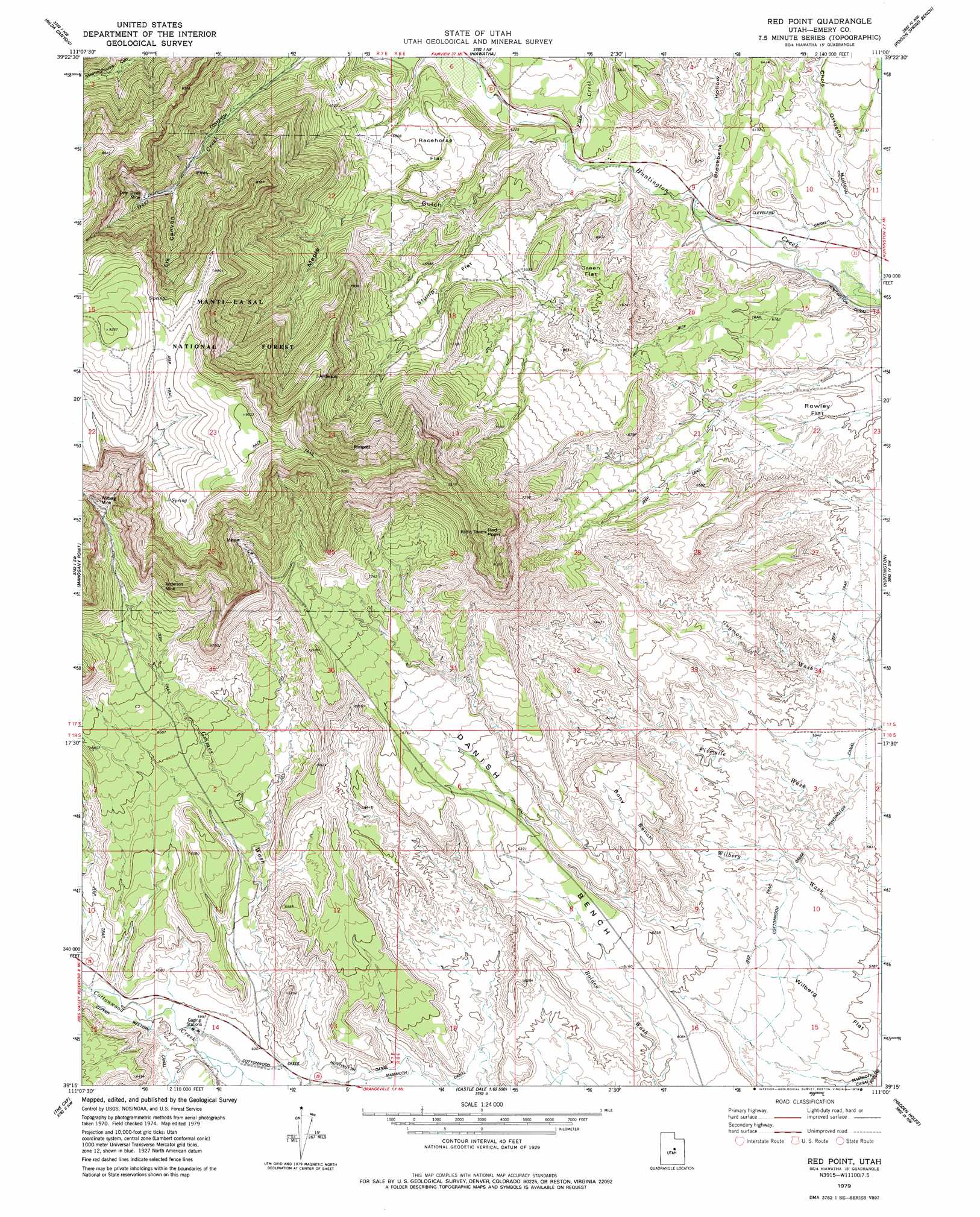
USGS Topo Quad 39111c1 - 1:24,000 scale
| Topo Map Name: | Red Point |
| USGS Topo Quad ID: | 39111c1 |
| Print Size: | ca. 21 1/4" wide x 27" high |
| Southeast Coordinates: | 39.25° N latitude / 111° W longitude |
| Map Center Coordinates: | 39.3125° N latitude / 111.0625° W longitude |
| U.S. State: | UT |
| Filename: | o39111c1.jpg |
| Download Map JPG Image: | Red Point topo map 1:24,000 scale |
| Map Type: | Topographic |
| Topo Series: | 7.5´ |
| Map Scale: | 1:24,000 |
| Source of Map Images: | United States Geological Survey (USGS) |
| Alternate Map Versions: |
Red Point UT 2001, updated 2004 Download PDF Buy paper map Red Point UT 2011 Download PDF Buy paper map Red Point UT 2014 Download PDF Buy paper map |
| FStopo: | US Forest Service topo Red Point is available: Download FStopo PDF Download FStopo TIF |
1:24,000 Topo Quads surrounding Red Point
Huntington Reservoir |
Candland Mountain |
Wattis |
Pinnacle Peak |
Price |
South Tent Mountain |
Rilda Canyon |
Hiawatha |
Poison Spring Bench |
Elmo |
Joes Valley Reservoir |
Mahogany Point |
Red Point |
Huntington |
Cleveland |
Ferron Canyon |
The Cap |
Castle Dale |
Hadden Holes |
Buckhorn Reservoir |
Flagstaff Peak |
Ferron |
Molen |
Horn Silver Gulch |
Sids Mountain |
> Back to 39111a1 at 1:100,000 scale
> Back to 39110a1 at 1:250,000 scale
> Back to U.S. Topo Maps home
Red Point topo map: Gazetteer
Red Point: Benches
Bony Bench elevation 1978m 6489′Danish Bench elevation 1857m 6092′
Red Point: Canals
Clipper Western Canal elevation 1841m 6040′Cottonwood Creek Huntington Canal elevation 1795m 5889′
Cottonwood Creek Huntington Canal elevation 1817m 5961′
Red Point: Capes
Red Point elevation 2555m 8382′Red Point: Flats
Green Flat elevation 1938m 6358′Racehorse Flat elevation 2011m 6597′
Rowley Flat elevation 1845m 6053′
Stump Flat elevation 2053m 6735′
Wilberg Flat elevation 1782m 5846′
Red Point: Mines
Anderson Mine elevation 2264m 7427′Deer Creek Mine elevation 2291m 7516′
Des-Bee-Drive Mine elevation 2364m 7755′
Wilberg Mine elevation 2322m 7618′
Red Point: Streams
Fish Creek elevation 1875m 6151′Red Point: Valleys
Brockbank Hollow elevation 1825m 5987′Chris Otteson Hollow elevation 1814m 5951′
Elk Canyon elevation 2233m 7326′
Maple Gulch elevation 1881m 6171′
Red Point digital topo map on disk
Buy this Red Point topo map showing relief, roads, GPS coordinates and other geographical features, as a high-resolution digital map file on DVD: