Lake Thunderhead Topo Map Missouri
To zoom in, hover over the map of Lake Thunderhead
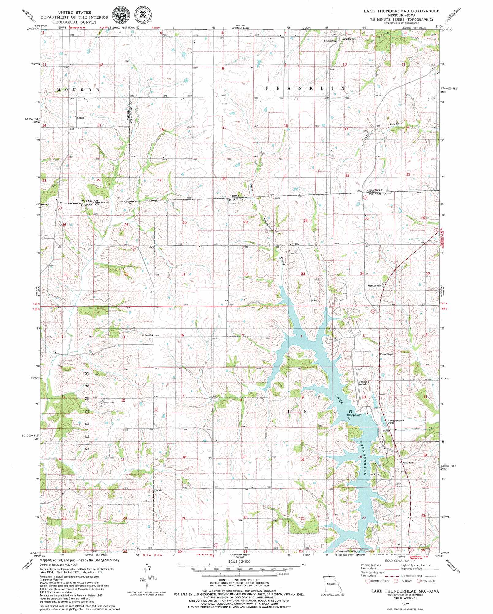
USGS Topo Quad 40093e1 - 1:24,000 scale
| Topo Map Name: | Lake Thunderhead |
| USGS Topo Quad ID: | 40093e1 |
| Print Size: | ca. 21 1/4" wide x 27" high |
| Southeast Coordinates: | 40.5° N latitude / 93° W longitude |
| Map Center Coordinates: | 40.5625° N latitude / 93.0625° W longitude |
| U.S. States: | MO, IA |
| Filename: | o40093e1.jpg |
| Download Map JPG Image: | Lake Thunderhead topo map 1:24,000 scale |
| Map Type: | Topographic |
| Topo Series: | 7.5´ |
| Map Scale: | 1:24,000 |
| Source of Map Images: | United States Geological Survey (USGS) |
| Alternate Map Versions: |
Lake Thunderhead MO 1979, updated 1980 Download PDF Buy paper map Lake Thunderhead MO 2010 Download PDF Buy paper map Lake Thunderhead MO 2012 Download PDF Buy paper map Lake Thunderhead MO 2015 Download PDF Buy paper map |
1:24,000 Topo Quads surrounding Lake Thunderhead
Corydon |
Confidence |
Plano |
Mystic |
Hiattsville |
Allerton |
Seymour West |
Seymour East |
Centerville West |
Centerville East |
Powersville |
Saint John |
Lake Thunderhead |
Mendota |
Omaha |
Lucerne |
Pollock Nw |
Unionville West |
Unionville East |
Graysville |
Harris |
Pollock Sw |
Pollock |
Green City |
Stahl |
> Back to 40093e1 at 1:100,000 scale
> Back to 40092a1 at 1:250,000 scale
> Back to U.S. Topo Maps home
Lake Thunderhead topo map: Gazetteer
Lake Thunderhead: Airports
Municipal Airport elevation 317m 1040′Unionville Airport elevation 318m 1043′
Lake Thunderhead: Dams
Lake Mahoney Dam elevation 308m 1010′Lake Thunderhead Dam elevation 282m 925′
Lake Thunderhead: Populated Places
Genoa elevation 328m 1076′Lake Thunderhead: Post Offices
Genoa Post Office (historical) elevation 325m 1066′Welland Post Office (historical) elevation 319m 1046′
Lake Thunderhead: Reservoirs
City Lake elevation 308m 1010′Lake Thunderhead elevation 282m 925′
Lake Thunderhead elevation 299m 980′
Unionville Reservoir elevation 298m 977′
Lake Thunderhead digital topo map on disk
Buy this Lake Thunderhead topo map showing relief, roads, GPS coordinates and other geographical features, as a high-resolution digital map file on DVD: