Coalmont Topo Map Colorado
To zoom in, hover over the map of Coalmont
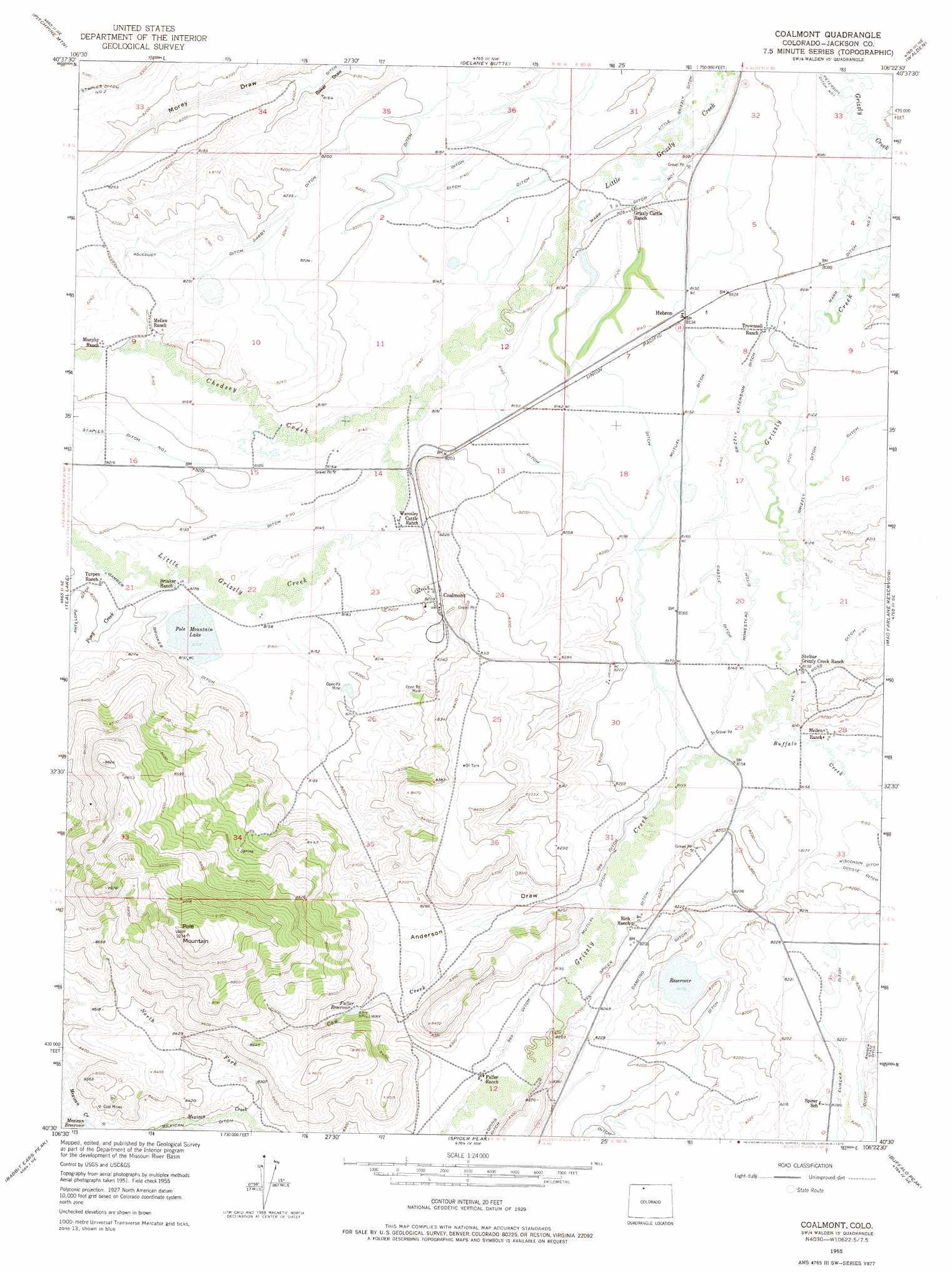
USGS Topo Quad 40106e4 - 1:24,000 scale
| Topo Map Name: | Coalmont |
| USGS Topo Quad ID: | 40106e4 |
| Print Size: | ca. 21 1/4" wide x 27" high |
| Southeast Coordinates: | 40.5° N latitude / 106.375° W longitude |
| Map Center Coordinates: | 40.5625° N latitude / 106.4375° W longitude |
| U.S. State: | CO |
| Filename: | o40106e4.jpg |
| Download Map JPG Image: | Coalmont topo map 1:24,000 scale |
| Map Type: | Topographic |
| Topo Series: | 7.5´ |
| Map Scale: | 1:24,000 |
| Source of Map Images: | United States Geological Survey (USGS) |
| Alternate Map Versions: |
Coalmont CO 1955, updated 1957 Download PDF Buy paper map Coalmont CO 1955, updated 1970 Download PDF Buy paper map Coalmont CO 1955, updated 1975 Download PDF Buy paper map Coalmont CO 2010 Download PDF Buy paper map Coalmont CO 2013 Download PDF Buy paper map Coalmont CO 2016 Download PDF Buy paper map |
1:24,000 Topo Quads surrounding Coalmont
Mount Zirkel |
Boettcher Lake |
Lake John |
Cowdrey |
Eagle Hill |
Mount Ethel |
Pitchpine Mountain |
Delaney Butte |
Walden |
Gould Nw |
Buffalo Pass |
Teal Lake |
Coalmont |
Macfarlane Reservoir |
Owl Ridge |
Mount Werner |
Rabbit Ears Peak |
Spicer Peak |
Buffalo Peak |
Rand |
Walton Peak |
Lake Agnes |
Whiteley Peak |
Hyannis Peak |
Parkview Mountain |
> Back to 40106e1 at 1:100,000 scale
> Back to 40106a1 at 1:250,000 scale
> Back to U.S. Topo Maps home
Coalmont topo map: Gazetteer
Coalmont: Canals
969 Ditch elevation 2507m 8225′Castle Ditch elevation 2482m 8143′
Damfino Ditch elevation 2506m 8221′
Darby Ditch elevation 2519m 8264′
Gamber Brinker Ditch elevation 2495m 8185′
Grizzly Ditch elevation 2476m 8123′
Grizzly Extension Ditch elevation 2476m 8123′
Homestead Ditch elevation 2479m 8133′
Marr Ditch Number 1 elevation 2465m 8087′
Marr Ditch Number 2 elevation 2466m 8090′
Mexican Ditch elevation 2532m 8307′
Mutual Ditch elevation 2493m 8179′
Nairn Ditch elevation 2491m 8172′
New Ross Ditch elevation 2482m 8143′
Spicer Ditch elevation 2498m 8195′
Coalmont: Dams
Petry Dam elevation 2477m 8126′Pole Mountain Dam elevation 2486m 8156′
Coalmont: Lakes
Pole Mountain Lake elevation 2486m 8156′Coalmont: Mines
Coalfire Mine elevation 2500m 8202′Moore Mine elevation 2509m 8231′
Moore Number Two Mine elevation 2546m 8353′
Moore Strip Pit elevation 2515m 8251′
North Park Coal Company Strip Mine elevation 2534m 8313′
Northern Colorado Coal Company Mine elevation 2527m 8290′
Rabbitear Mine elevation 2562m 8405′
Rosebud Mine elevation 2494m 8182′
Rosebud Number One Mine elevation 2496m 8188′
Rosebud Number Two Mine elevation 2517m 8257′
Spicer Mine elevation 2493m 8179′
Taylor Mine elevation 2494m 8182′
Coalmont: Populated Places
Coalmont elevation 2504m 8215′Hebron elevation 2482m 8143′
Coalmont: Reservoirs
Fuller Reservoir elevation 2533m 8310′Petry Lake elevation 2477m 8126′
Coalmont: Streams
Buffalo Creek elevation 2482m 8143′Chedsey Creek elevation 2476m 8123′
Cow Creek elevation 2508m 8228′
North Fork Mexican Creek elevation 2525m 8284′
Pony Creek elevation 2488m 8162′
Soap Creek elevation 2464m 8083′
Coalmont: Summits
Pole Mountain elevation 2814m 9232′Coalmont: Valleys
Anderson Draw elevation 2499m 8198′Morley Draw elevation 2467m 8093′
Coalmont digital topo map on disk
Buy this Coalmont topo map showing relief, roads, GPS coordinates and other geographical features, as a high-resolution digital map file on DVD: