Pagoda Peak Topo Map Colorado
To zoom in, hover over the map of Pagoda Peak
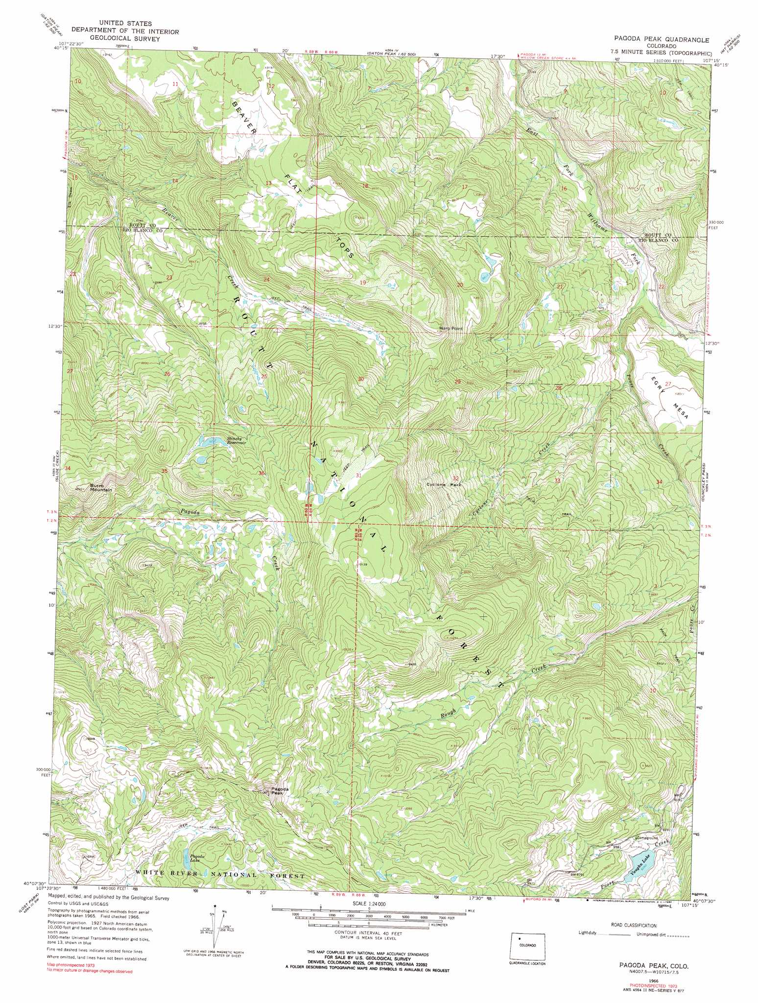
USGS Topo Quad 40107b3 - 1:24,000 scale
| Topo Map Name: | Pagoda Peak |
| USGS Topo Quad ID: | 40107b3 |
| Print Size: | ca. 21 1/4" wide x 27" high |
| Southeast Coordinates: | 40.125° N latitude / 107.25° W longitude |
| Map Center Coordinates: | 40.1875° N latitude / 107.3125° W longitude |
| U.S. State: | CO |
| Filename: | o40107b3.jpg |
| Download Map JPG Image: | Pagoda Peak topo map 1:24,000 scale |
| Map Type: | Topographic |
| Topo Series: | 7.5´ |
| Map Scale: | 1:24,000 |
| Source of Map Images: | United States Geological Survey (USGS) |
| Alternate Map Versions: |
Pagoda Peak CO 1966, updated 1969 Download PDF Buy paper map Pagoda Peak CO 1966, updated 1969 Download PDF Buy paper map Pagoda Peak CO 1966, updated 1970 Download PDF Buy paper map Pagoda Peak CO 1966, updated 1990 Download PDF Buy paper map Pagoda Peak CO 1966, updated 1990 Download PDF Buy paper map Pagoda Peak CO 2000 Download PDF Buy paper map Pagoda Peak CO 2011 Download PDF Buy paper map Pagoda Peak CO 2013 Download PDF Buy paper map Pagoda Peak CO 2016 Download PDF Buy paper map |
| FStopo: | US Forest Service topo Pagoda Peak is available: Download FStopo PDF Download FStopo TIF |
1:24,000 Topo Quads surrounding Pagoda Peak
Castor Gulch |
Breeze Mountain |
Hayden |
Mount Harris |
Milner |
Hamilton |
Pagoda |
Hayden Gulch |
Dunckley |
Rattlesnake Butte |
Sleepy Cat Peak |
Slide Creek |
Pagoda Peak |
Dunckley Pass |
Sand Point |
Fawn Creek |
Lost Park |
Ripple Creek |
Devils Causeway |
Orno Peak |
Buford |
Oyster Lake |
Big Marvine Peak |
Trappers Lake |
Dome Peak |
> Back to 40107a1 at 1:100,000 scale
> Back to 40106a1 at 1:250,000 scale
> Back to U.S. Topo Maps home
Pagoda Peak topo map: Gazetteer
Pagoda Peak: Cliffs
Harp Point elevation 2882m 9455′Pagoda Peak: Dams
Gill Reservoir Dam elevation 2459m 8067′Poose Creek Dam elevation 2864m 9396′
Pagoda Peak: Flats
Cyclone Park elevation 2735m 8973′Pagoda Peak: Lakes
Pagoda Lake elevation 3145m 10318′Vaughan Lake elevation 2863m 9393′
Pagoda Peak: Reservoirs
Gill Reservoir elevation 2459m 8067′Stinsby Reservoir elevation 2836m 9304′
Pagoda Peak: Streams
Cyclone Creek elevation 2352m 7716′Poose Creek elevation 2330m 7644′
Pagoda Peak: Summits
Beaver Flat Tops elevation 2893m 9491′Burro Mountain elevation 2991m 9812′
Pagoda Peak elevation 3388m 11115′
Pagoda Peak digital topo map on disk
Buy this Pagoda Peak topo map showing relief, roads, GPS coordinates and other geographical features, as a high-resolution digital map file on DVD: