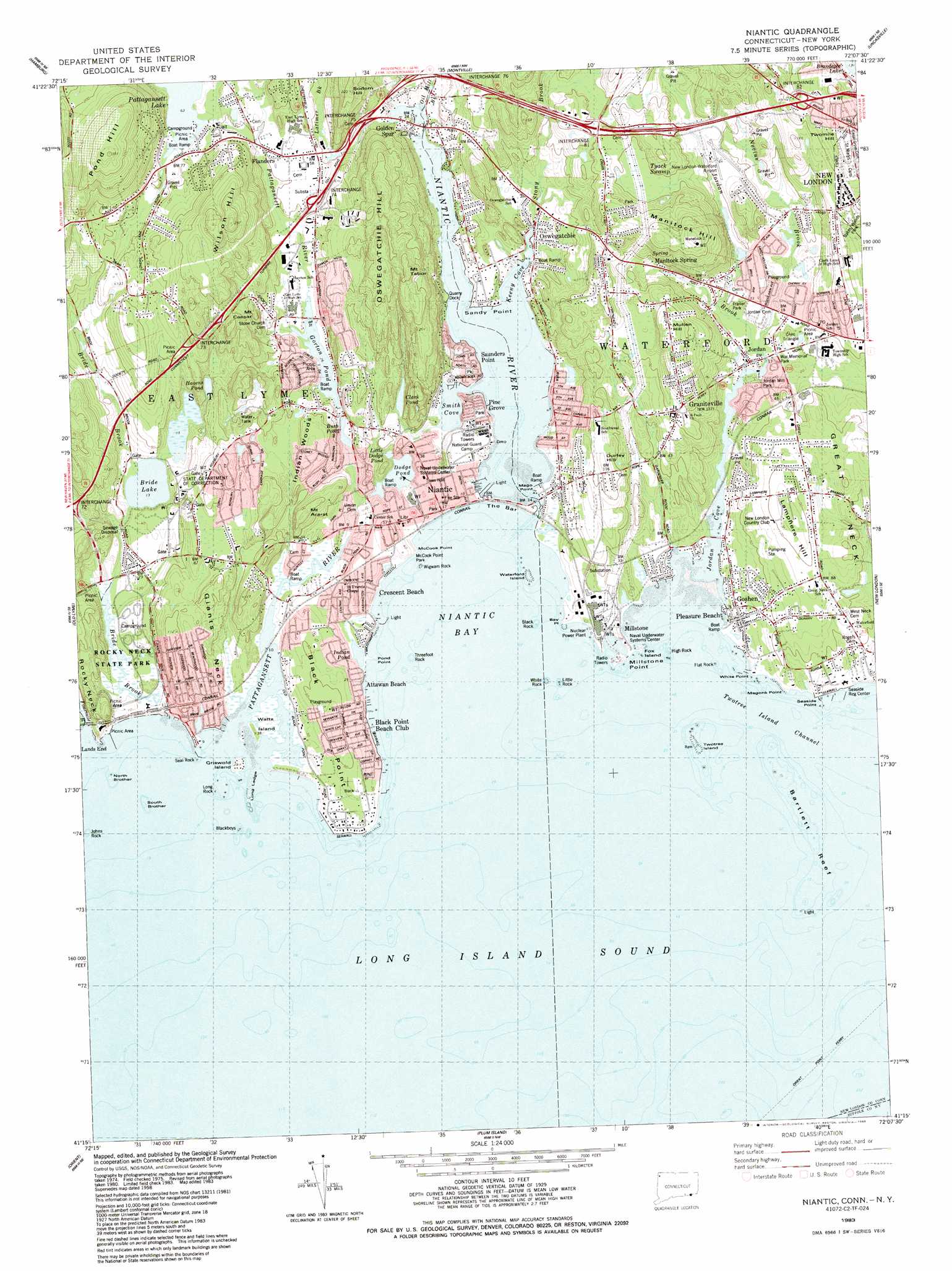
Niantic Topo Map Connecticut
To zoom in, hover over the map of Niantic
USGS Topo Quad 41072c2 - 1:24,000 scale
| Topo Map Name: | Niantic |
| USGS Topo Quad ID: | 41072c2 |
| Print Size: | ca. 21 1/4" wide x 27" high |
| Southeast Coordinates: | 41.25° N latitude / 72.125° W longitude |
| Map Center Coordinates: | 41.3125° N latitude / 72.1875° W longitude |
| U.S. States: | CT, NY |
| Filename: | o41072c2.jpg |
| Download Map JPG Image: | Niantic topo map 1:24,000 scale |
| Map Type: | Topographic |
| Topo Series: | 7.5´ |
| Map Scale: | 1:24,000 |
| Source of Map Images: | United States Geological Survey (USGS) |
| Alternate Map Versions: |
Niantic CT 1934 Download PDF Buy paper map Niantic CT 1958, updated 1959 Download PDF Buy paper map Niantic CT 1958, updated 1966 Download PDF Buy paper map Niantic CT 1958, updated 1971 Download PDF Buy paper map Niantic CT 1983, updated 1983 Download PDF Buy paper map Niantic CT 1983, updated 1988 Download PDF Buy paper map Niantic CT 1983, updated 1988 Download PDF Buy paper map Niantic CT 2012 Download PDF Buy paper map Niantic CT 2015 Download PDF Buy paper map |
1:24,000 Topo Quads surrounding Niantic
Moodus |
Colchester |
Fitchville |
Norwich |
Jewett City |
Deep River |
Hamburg |
Montville |
Uncasville |
Old Mystic |
Essex |
Old Lyme |
Niantic |
New London |
Mystic |
Orient |
Plum Island |
|||
Southold |
Greenport |
Gardiners Island West |
Gardiners Island East |
Montauk Point |
> Back to 41072a1 at 1:100,000 scale
> Back to 41072a1 at 1:250,000 scale
> Back to U.S. Topo Maps home
Niantic topo map: Gazetteer
Niantic: Bars
Bartlett Reef elevation 0m 0′Long Ledge elevation 0m 0′
The Bar elevation 0m 0′
Niantic: Basins
Sanctuary Basin elevation 5m 16′Niantic: Bays
Banning Cove elevation 0m 0′Jordan Cove elevation 0m 0′
Keeny Cove elevation 0m 0′
Niantic Bay elevation 0m 0′
Smith Cove elevation 0m 0′
The Gut elevation 0m 0′
Niantic: Beaches
Attawan Beach elevation 4m 13′Giants Neck Beach elevation 5m 16′
Kiddie Beach elevation 0m 0′
Rocky Neck State Park Bathing Beach elevation 7m 22′
Niantic: Bridges
Niantic Bridge elevation 1m 3′Straightsbridge elevation 0m 0′
Niantic: Capes
Bay Point elevation 2m 6′Black Point elevation 24m 78′
Giants Neck elevation 24m 78′
Mago Point elevation 0m 0′
Magonk Point elevation 2m 6′
McCook Point elevation 0m 0′
Millstone Point elevation 0m 0′
Pond Point elevation 1m 3′
Rocky Hill Neck elevation 27m 88′
Rocky Neck elevation 23m 75′
Seaside Point elevation 0m 0′
White Point elevation 5m 16′
Niantic: Channels
Twotree Island Channel elevation 0m 0′Niantic: Crossings
Interchange 72 elevation 27m 88′Interchange 73 elevation 43m 141′
Interchange 74 elevation 14m 45′
Interchange 75 elevation 12m 39′
Interchange 76 elevation 7m 22′
Interchange 81 elevation 26m 85′
Interchange 82 elevation 47m 154′
Niantic: Dams
Gorton Pond Dam elevation 10m 32′Jordan Mill Pond Dam elevation 0m 0′
Pataguanset Lake Dam elevation 11m 36′
Niantic: Forests
Indian Woods elevation 38m 124′Niantic: Islands
Black Rock elevation 0m 0′Blackboys elevation 0m 0′
Flat Rock elevation 0m 0′
Fox Island elevation 0m 0′
Griswold Island elevation 1m 3′
High Rock elevation 0m 0′
Huntley Island elevation 2m 6′
Huntley Island elevation 2m 6′
Johns Rock elevation 0m 0′
Little Rock elevation 0m 0′
Long Rock elevation 0m 0′
North Brother elevation 0m 0′
Seal Rock elevation 0m 0′
South Brother elevation 0m 0′
Threefoot Rock elevation 0m 0′
Twotree Island elevation 0m 0′
Waterford Island elevation 0m 0′
Watts Island elevation 0m 0′
White Rock elevation 0m 0′
Wigwam Rock elevation 0m 0′
Niantic: Lakes
Bride Lake elevation 4m 13′Bush Pond elevation 13m 42′
Clark Pond elevation 12m 39′
Dodge Pond elevation 3m 9′
Havens Pond elevation 28m 91′
Indian Pond elevation 3m 9′
Little Dodge Pond elevation 8m 26′
Niantic: Parks
Babe Ruth Field elevation 16m 52′Jordan Green elevation 5m 16′
Jordan Village Historic District elevation 9m 29′
Little League Fields South elevation 4m 13′
Marilyn Road Park elevation 38m 124′
Moran Nature Center and Zoo elevation 38m 124′
North Road Park elevation 7m 22′
Rocky Neck State Park elevation 6m 19′
Spera Soccer Field elevation 19m 62′
Niantic: Plains
Wolf Pit Plain elevation 1m 3′Niantic: Populated Places
Attawan Beach elevation 14m 45′Black Point elevation 6m 19′
Black Point Beach Club elevation 6m 19′
Crescent Beach elevation 0m 0′
Crescent Park elevation 0m 0′
Flanders elevation 13m 42′
Giants Neck elevation 18m 59′
Golden Spur elevation 9m 29′
Graniteville elevation 37m 121′
Jordan elevation 7m 22′
Manitock Spring elevation 34m 111′
Millstone elevation 8m 26′
Morningside Park elevation 33m 108′
Morningside Park elevation 9m 29′
Niantic elevation 9m 29′
Oswegatchie elevation 5m 16′
Pine Grove elevation 3m 9′
Pleasure Beach elevation 10m 32′
Sandy Point elevation 4m 13′
Saunders Point elevation 1m 3′
Seaside elevation 18m 59′
Seaside elevation 17m 55′
Niantic: Post Offices
East Lyme Post Office elevation 16m 52′Niantic Post Office elevation 8m 26′
Waterford Post Office elevation 14m 45′
Niantic: Reservoirs
Gorton Pond elevation 10m 32′Jordan Mill Pond elevation 0m 0′
Pattagansett Lake elevation 19m 62′
Perry Pond elevation 10m 32′
Perry Pond elevation 8m 26′
Niantic: Springs
Manitock Spring elevation 36m 118′Niantic: Streams
Beaver Dam Brook elevation 4m 13′Bride Brook elevation 5m 16′
Fourmile River elevation 3m 9′
Latimer Brook elevation 0m 0′
Nevins Brook elevation 1m 3′
Niantic River elevation 0m 0′
Oil Mill Brook elevation 0m 0′
Pattagansett River elevation 0m 0′
Red Brook elevation 0m 0′
Stony Brook elevation 2m 6′
Niantic: Summits
Baptist Hill elevation 17m 55′Durfey Hill elevation 32m 104′
Green Hill elevation 44m 144′
Lamphere Hill elevation 39m 127′
Manitock Hill elevation 63m 206′
Mount Ararat elevation 30m 98′
Mount Caesar elevation 38m 124′
Mount Tabor elevation 74m 242′
Mullen Hill elevation 53m 173′
Oswegatchie Hill elevation 77m 252′
Pond Hill elevation 103m 337′
Sodom Hill elevation 59m 193′
Twomile Hill elevation 62m 203′
Wilson Hill elevation 79m 259′
Niantic digital topo map on disk
Buy this Niantic topo map showing relief, roads, GPS coordinates and other geographical features, as a high-resolution digital map file on DVD:
New York, Vermont, Connecticut & Western Massachusetts
Buy digital topo maps: New York, Vermont, Connecticut & Western Massachusetts