Aurora South Topo Map Illinois
To zoom in, hover over the map of Aurora South
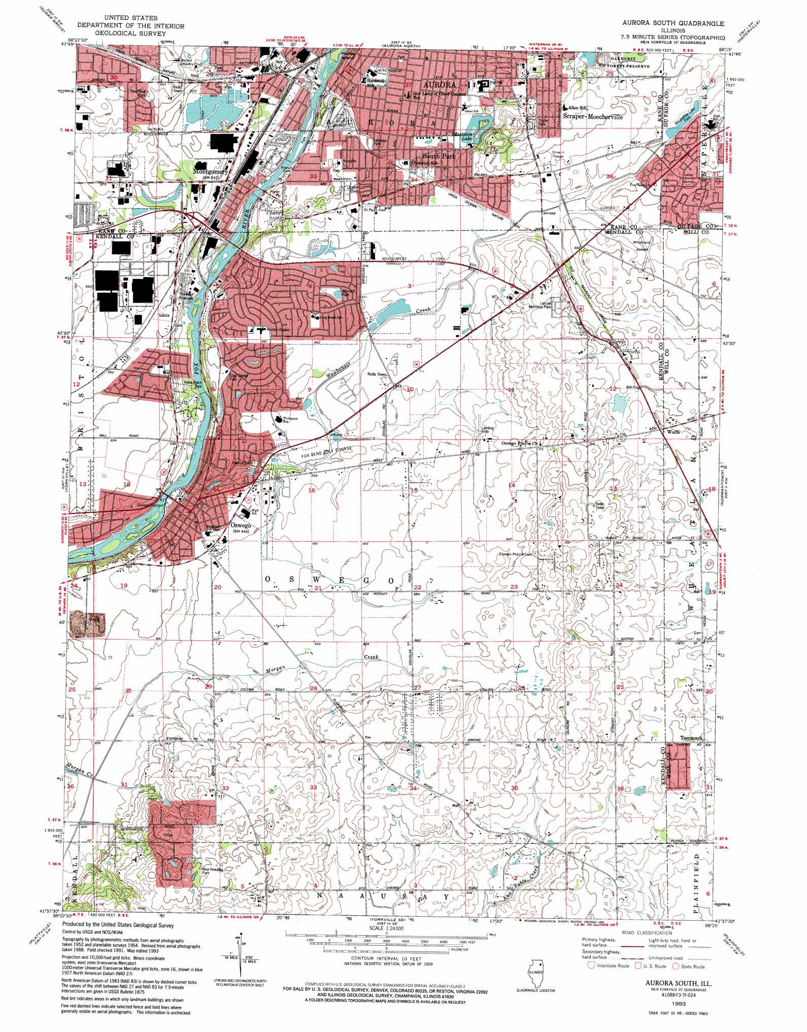
USGS Topo Quad 41088f3 - 1:24,000 scale
| Topo Map Name: | Aurora South |
| USGS Topo Quad ID: | 41088f3 |
| Print Size: | ca. 21 1/4" wide x 27" high |
| Southeast Coordinates: | 41.625° N latitude / 88.25° W longitude |
| Map Center Coordinates: | 41.6875° N latitude / 88.3125° W longitude |
| U.S. State: | IL |
| Filename: | o41088f3.jpg |
| Download Map JPG Image: | Aurora South topo map 1:24,000 scale |
| Map Type: | Topographic |
| Topo Series: | 7.5´ |
| Map Scale: | 1:24,000 |
| Source of Map Images: | United States Geological Survey (USGS) |
| Alternate Map Versions: |
Aurora South IL 1954, updated 1955 Download PDF Buy paper map Aurora South IL 1954, updated 1974 Download PDF Buy paper map Aurora South IL 1954, updated 1981 Download PDF Buy paper map Aurora South IL 1954, updated 1988 Download PDF Buy paper map Aurora South IL 1993, updated 1994 Download PDF Buy paper map Aurora South IL 2012 Download PDF Buy paper map Aurora South IL 2015 Download PDF Buy paper map |
1:24,000 Topo Quads surrounding Aurora South
Maple Park |
Elburn |
Geneva |
West Chicago |
Lombard |
Big Rock |
Sugar Grove |
Aurora North |
Naperville |
Wheaton |
Plano |
Yorkville |
Aurora South |
Normantown |
Romeoville |
Newark |
Plattville |
Yorkville Se |
Plainfield |
Joliet |
Stavanger |
Lisbon |
Minooka |
Channahon |
Elwood |
> Back to 41088e1 at 1:100,000 scale
> Back to 41088a1 at 1:250,000 scale
> Back to U.S. Topo Maps home
Aurora South topo map: Gazetteer
Aurora South: Airports
Caterpillar Aurora Heliport elevation 201m 659′Flying M Farm Airport elevation 204m 669′
Wheatland Field elevation 208m 682′
Wormley Airport elevation 215m 705′
Aurora South: Lakes
Mastodon Lake elevation 201m 659′Aurora South: Parks
Augusta Lake Park elevation 196m 643′Berman Park elevation 187m 613′
Briarcliff Woods Park elevation 207m 679′
Civic Center Park elevation 197m 646′
Copley Island Park elevation 198m 649′
Crescent Park elevation 213m 698′
Cumberland Park elevation 214m 702′
Heritage Park elevation 202m 662′
Jaycee Park elevation 199m 652′
Kiehl Park elevation 198m 649′
Krug Park elevation 195m 639′
Lebanon Park elevation 198m 649′
Montgomery Park elevation 186m 610′
Northampton Park elevation 199m 652′
Phillips Park elevation 211m 692′
Phillips Park Zoo elevation 211m 692′
Pierce Park elevation 204m 669′
Pine Knoll Park elevation 201m 659′
Porter Park elevation 196m 643′
South River Street Park elevation 189m 620′
Stonegate Park elevation 190m 623′
Susan John Park elevation 203m 666′
Victor Dunn Memorial Park elevation 200m 656′
Violet Patch Park elevation 184m 603′
Waa Kee Sha Park elevation 229m 751′
Westwood Park elevation 201m 659′
Winrock Park elevation 203m 666′
Aurora South: Populated Places
Boulder Hill elevation 204m 669′Hunters Ridge elevation 211m 692′
Montgomery elevation 195m 639′
Oswego elevation 195m 639′
Scraper-Moecherville elevation 214m 702′
South Park elevation 202m 662′
Tamarack elevation 207m 679′
Wheatland Plains elevation 211m 692′
Wolfs elevation 216m 708′
Aurora South: Post Offices
Oswego Post Office elevation 197m 646′Aurora South: Streams
Waubonsie Creek elevation 182m 597′Aurora South: Swamps
Big Slough (historical) elevation 190m 623′Aurora South digital topo map on disk
Buy this Aurora South topo map showing relief, roads, GPS coordinates and other geographical features, as a high-resolution digital map file on DVD:
Northern Illinois, Northern Indiana & Southwestern Michigan
Buy digital topo maps: Northern Illinois, Northern Indiana & Southwestern Michigan