Normantown Topo Map Illinois
To zoom in, hover over the map of Normantown
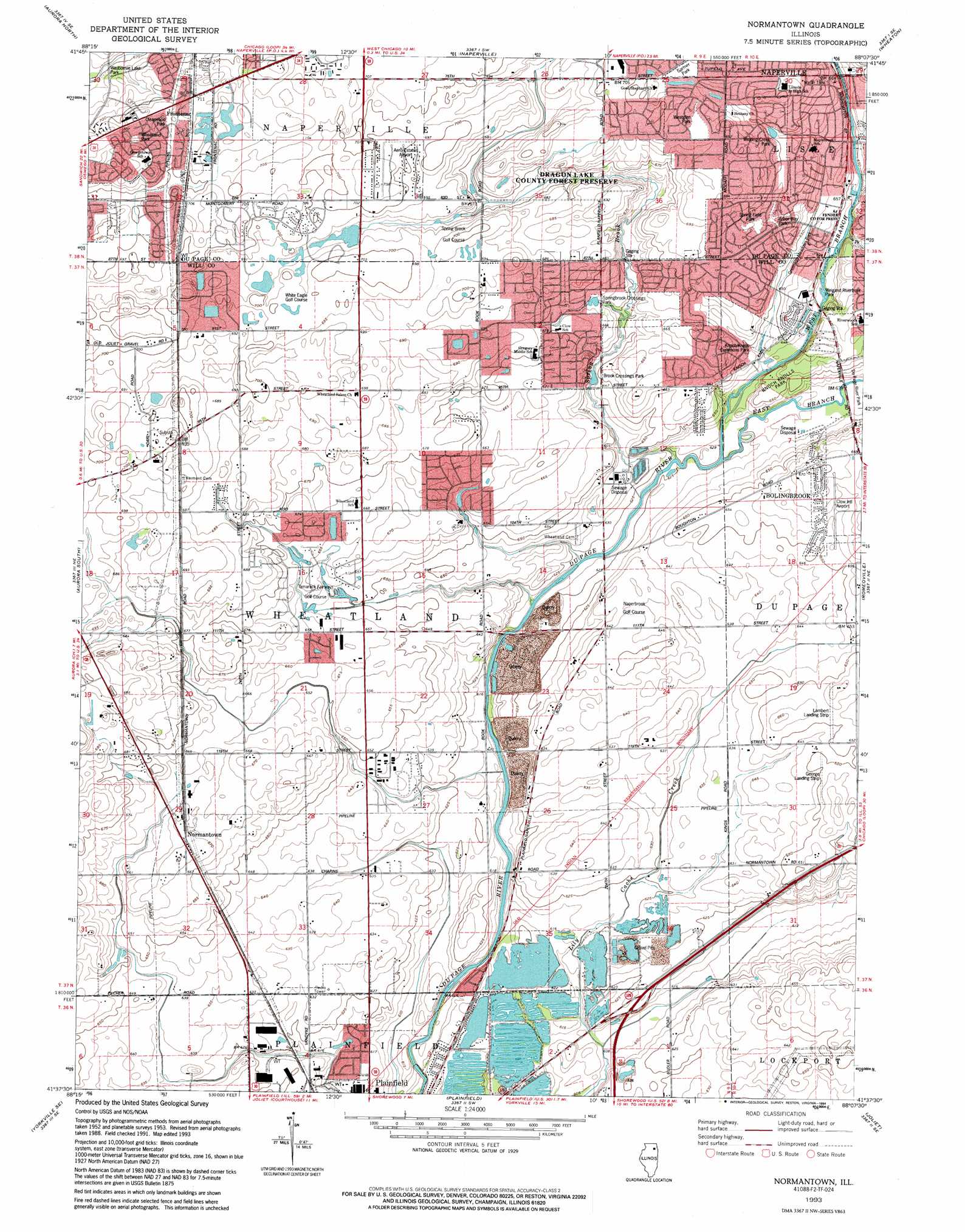
USGS Topo Quad 41088f2 - 1:24,000 scale
| Topo Map Name: | Normantown |
| USGS Topo Quad ID: | 41088f2 |
| Print Size: | ca. 21 1/4" wide x 27" high |
| Southeast Coordinates: | 41.625° N latitude / 88.125° W longitude |
| Map Center Coordinates: | 41.6875° N latitude / 88.1875° W longitude |
| U.S. State: | IL |
| Filename: | o41088f2.jpg |
| Download Map JPG Image: | Normantown topo map 1:24,000 scale |
| Map Type: | Topographic |
| Topo Series: | 7.5´ |
| Map Scale: | 1:24,000 |
| Source of Map Images: | United States Geological Survey (USGS) |
| Alternate Map Versions: |
Normantown IL 1953, updated 1955 Download PDF Buy paper map Normantown IL 1962, updated 1963 Download PDF Buy paper map Normantown IL 1962, updated 1974 Download PDF Buy paper map Normantown IL 1962, updated 1981 Download PDF Buy paper map Normantown IL 1993, updated 1994 Download PDF Buy paper map Normantown IL 2012 Download PDF Buy paper map Normantown IL 2015 Download PDF Buy paper map |
1:24,000 Topo Quads surrounding Normantown
Elburn |
Geneva |
West Chicago |
Lombard |
Elmhurst |
Sugar Grove |
Aurora North |
Naperville |
Wheaton |
Hinsdale |
Yorkville |
Aurora South |
Normantown |
Romeoville |
Sag Bridge |
Plattville |
Yorkville Se |
Plainfield |
Joliet |
Mokena |
Lisbon |
Minooka |
Channahon |
Elwood |
Manhattan |
> Back to 41088e1 at 1:100,000 scale
> Back to 41088a1 at 1:250,000 scale
> Back to U.S. Topo Maps home
Normantown topo map: Gazetteer
Normantown: Airports
Aero Estates Airport elevation 214m 702′Clow International Airport elevation 200m 656′
Day Airport elevation 193m 633′
George Airport (historical) elevation 198m 649′
Lambert Airport (historical) elevation 199m 652′
Naper Aero Club Airport elevation 216m 708′
Normantown: Crossings
Interchange 261 elevation 192m 629′Normantown: Mines
Plainfield Quarry elevation 191m 626′Normantown: Parks
Andover Park elevation 215m 705′Arbor Way Park elevation 200m 656′
Brook Crossings Park elevation 197m 646′
Clearwood Park elevation 215m 705′
Dragon Lake County Forest Preserve elevation 214m 702′
Fender County Forest Preserve elevation 197m 646′
Gartner Park elevation 211m 692′
Knoch Knolls Commons Park elevation 195m 639′
Knoch Knolls Park elevation 199m 652′
Ridge Park elevation 216m 708′
Spring Field Park elevation 204m 669′
Springbrook Crossings Park elevation 201m 659′
Vermont Cemetery Prairie Nature Preserve elevation 210m 688′
Waubonsie Lake Park elevation 206m 675′
Weigand Riverfront Park elevation 197m 646′
Westglen Park elevation 211m 692′
Wheatland Park elevation 216m 708′
Winding Creek Park elevation 205m 672′
Normantown: Populated Places
Bloomfield West elevation 195m 639′Breckenridge Estates elevation 203m 666′
Brook Crossings Estates elevation 209m 685′
Brookwood Estates elevation 201m 659′
Burnham Point elevation 210m 688′
Cambridge Place elevation 185m 606′
Carillon elevation 200m 656′
Champion Creek elevation 200m 656′
Cider Creek elevation 196m 643′
Clow Creek Farm elevation 203m 666′
Country View Estates elevation 207m 679′
Crestview Knolls elevation 204m 669′
Crossing elevation 205m 672′
Foxridge Farms elevation 192m 629′
Frontenac elevation 217m 711′
Golden Meadow Estates elevation 195m 639′
Graver Country Estates elevation 194m 636′
Harvest Glen elevation 194m 636′
Heatherstone elevation 212m 695′
Heritage Knolls elevation 201m 659′
Heritage Meadows elevation 196m 643′
Heritage Place elevation 192m 629′
Hickory Oaks elevation 200m 656′
High Meadow elevation 200m 656′
Indian Boundary elevation 198m 649′
Kensington Club elevation 193m 633′
Lakewood Falls elevation 194m 636′
Normantown elevation 204m 669′
Old Sawmill elevation 204m 669′
Pheasant Chase elevation 195m 639′
Plainfield elevation 188m 616′
Plantation elevation 198m 649′
Ponds of Plainfield elevation 193m 633′
Prairie Knoll elevation 196m 643′
Prairie Ponds elevation 202m 662′
Prairie Ridge elevation 201m 659′
Quail Run elevation 188m 616′
Reserve of Plainfield elevation 186m 610′
Reserves at Clearwater elevation 212m 695′
River Edge Estates elevation 188m 616′
River Oaks elevation 198m 649′
River Woods elevation 201m 659′
Riverbend elevation 191m 626′
Rivercrest Estates elevation 201m 659′
Rivermist elevation 195m 639′
Rose Hill Farms elevation 201m 659′
Saddle Creek elevation 197m 646′
Shell Lake Estates elevation 209m 685′
Shenandoah elevation 204m 669′
Somerfield elevation 199m 652′
Southgate Park elevation 195m 639′
Stillwater elevation 214m 702′
Tamarack Fairways elevation 202m 662′
Tuttle Farm elevation 204m 669′
Walkers Grove elevation 196m 643′
Wheatland Highlands elevation 203m 666′
Wheatland South elevation 204m 669′
Wheatland View elevation 209m 685′
Winchester Place elevation 201m 659′
Wolf Creek Estates elevation 191m 626′
Wolf Creek Island elevation 197m 646′
Woodlake elevation 212m 695′
Woods of Rivermist elevation 195m 639′
Normantown: Post Offices
East Wheatland Post Office (historical) elevation 196m 643′Normantown: Streams
East Branch Du Page River elevation 190m 623′Spring Brook elevation 189m 620′
West Branch Du Page River elevation 190m 623′
Normantown digital topo map on disk
Buy this Normantown topo map showing relief, roads, GPS coordinates and other geographical features, as a high-resolution digital map file on DVD:
Northern Illinois, Northern Indiana & Southwestern Michigan
Buy digital topo maps: Northern Illinois, Northern Indiana & Southwestern Michigan