High Plateau Mountain Topo Map California
To zoom in, hover over the map of High Plateau Mountain
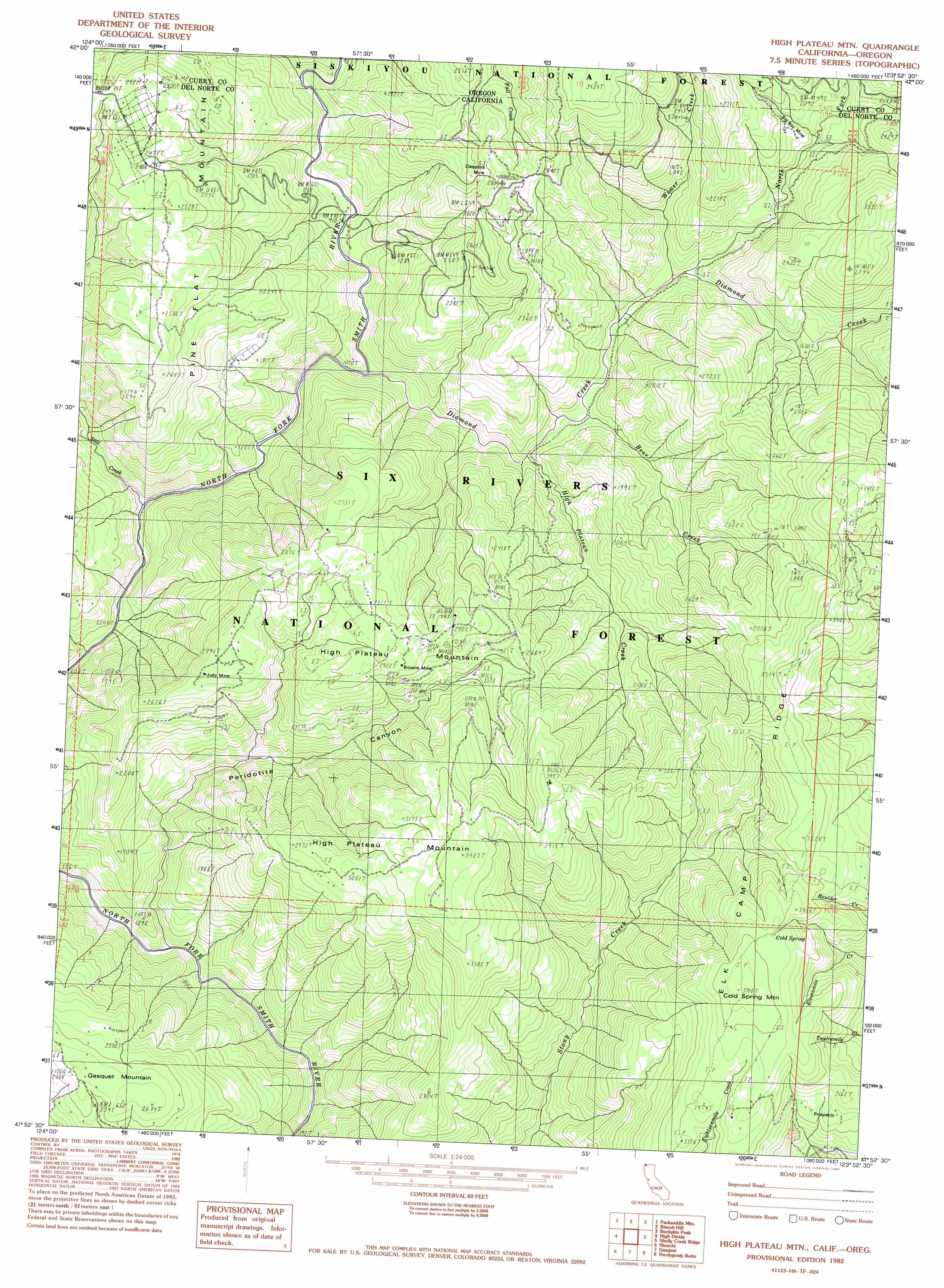
USGS Topo Quad 41123h8 - 1:24,000 scale
| Topo Map Name: | High Plateau Mountain |
| USGS Topo Quad ID: | 41123h8 |
| Print Size: | ca. 21 1/4" wide x 27" high |
| Southeast Coordinates: | 41.875° N latitude / 123.875° W longitude |
| Map Center Coordinates: | 41.9375° N latitude / 123.9375° W longitude |
| U.S. States: | CA, OR |
| Filename: | o41123h8.jpg |
| Download Map JPG Image: | High Plateau Mountain topo map 1:24,000 scale |
| Map Type: | Topographic |
| Topo Series: | 7.5´ |
| Map Scale: | 1:24,000 |
| Source of Map Images: | United States Geological Survey (USGS) |
| Alternate Map Versions: |
Gasquet NW CA 1975 Download PDF Buy paper map High Plateau Mtn. CA 1982, updated 1982 Download PDF Buy paper map High Plateau Mountain CA 1997, updated 2001 Download PDF Buy paper map High Plateau Mountain CA 2012 Download PDF Buy paper map High Plateau Mountain CA 2015 Download PDF Buy paper map |
| FStopo: | US Forest Service topo High Plateau Mountain is available: Download FStopo PDF Download FStopo TIF |
1:24,000 Topo Quads surrounding High Plateau Mountain
Bosley Butte |
Quail Prairie Mountain |
Chetco Peak |
Josephine Mountain |
Cave Junction |
Mount Emily |
Fourth Of July Creek |
Biscuit Hill |
Buckskin Peak |
O'Brien |
Smith River |
High Divide |
High Plateau Mountain |
Shelly Creek Ridge |
Broken Rib Mountain |
Crescent City |
Hiouchi |
Gasquet |
Hurdygurdy Butte |
Devils Punchbowl |
Sister Rocks |
Childs Hill |
Cant Hook Mountain |
Ship Mountain |
Prescott Mountain |
> Back to 41123e1 at 1:100,000 scale
> Back to 41122a1 at 1:250,000 scale
> Back to U.S. Topo Maps home
High Plateau Mountain topo map: Gazetteer
High Plateau Mountain: Mines
Big Boy Mine elevation 700m 2296′Bluebird Mine elevation 768m 2519′
Bonanza Mine elevation 879m 2883′
Browns Mine elevation 851m 2791′
Cleopatra Mine elevation 709m 2326′
Diamond Creek Mine elevation 389m 1276′
Judy Mine elevation 834m 2736′
Pine Flat Chromite Mine elevation 736m 2414′
Skyline Mine elevation 645m 2116′
Sunny Brook Prospect elevation 543m 1781′
Tangarene Mine elevation 985m 3231′
Toujours Gal Mine elevation 1028m 3372′
Webb Mine elevation 828m 2716′
High Plateau Mountain: Populated Places
Rockland elevation 278m 912′High Plateau Mountain: Ridges
Elk Camp Ridge elevation 1104m 3622′High Plateau Mountain: Springs
Cold Spring elevation 1075m 3526′High Plateau Mountain: Streams
Bear Creek elevation 335m 1099′Cedar Creek elevation 290m 951′
Diamond Creek elevation 253m 830′
Diamond Creek elevation 253m 830′
High Plateau Creek elevation 304m 997′
North Fork Diamond Creek elevation 389m 1276′
North Fork Diamond Creek elevation 383m 1256′
Still Creek elevation 213m 698′
Wimer Creek elevation 378m 1240′
Winner Creek elevation 384m 1259′
High Plateau Mountain: Summits
Cold Spring Mountain elevation 1125m 3690′Gasquet Mountain elevation 793m 2601′
High Plateau Mountain elevation 1060m 3477′
Pine Flat Mountain elevation 806m 2644′
High Plateau Mountain: Trails
Elk Camp Ridge Trail elevation 990m 3248′High Plateau Mountain: Valleys
Peridotite Canyon elevation 215m 705′High Plateau Mountain digital topo map on disk
Buy this High Plateau Mountain topo map showing relief, roads, GPS coordinates and other geographical features, as a high-resolution digital map file on DVD: